- Joined
- May 5, 2012
- Messages
- 1,725
Up the long ladder.
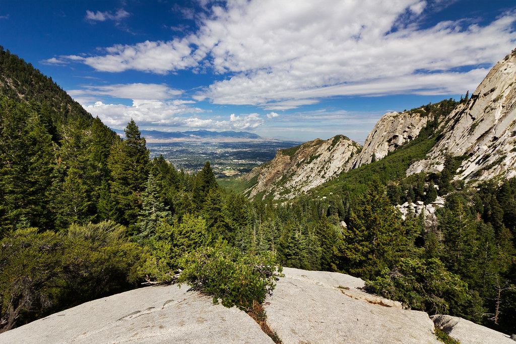
The common trail into Bells Canyon begins in the Wasatch foothills at the mouth of Little Cottonwood Canyon. Suburban development has cut off the best approaches into the canyon, so most hikers access it from the Sandy City/Salt Lake County trailhead located near 9600 South Wasatch Boulevard. From here, the trail switches up through gambel oak and sage before crossing south toward lower Bells Canyon Reservoir.

Once at the lower reservoir, the view up into Bells itself is revealed.
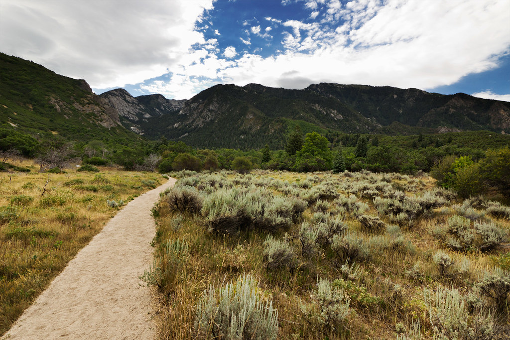
Entering Bells Canyon by ashergrey, on Flickr
Bells Canyon is popular with hikers and mountain climbers. The former mostly seek out the lower falls about two miles up while the latter are drawn to the Bell Tower slabs. Bells sits immediately south of Little Cottonwood and ascends toward Lone Peak. It shares much of the same terrain features as trails in Little Cottonwood proper.
My brother and I tackled the climb to Upper Bells Canyon Reservoir on the 24th of July, 2012. We started a bit later than I'd intended, making it on trail sometime between 8:30 and 9 a.m. The morning started cooler than most in Utah's summer, thanks to mostly overcast skies.
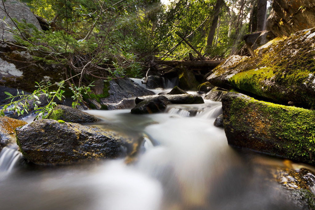
Older trip reports on the web speak of numerous stream crossings on improvised log bridges. This does not appear to be the case any longer. A prominent crossing just a few minutes in from the lower reservoir is now made by way of a sturdy constructed bridge. It is here that the highlight of the hike first becomes apparent. Hint: it's the water.
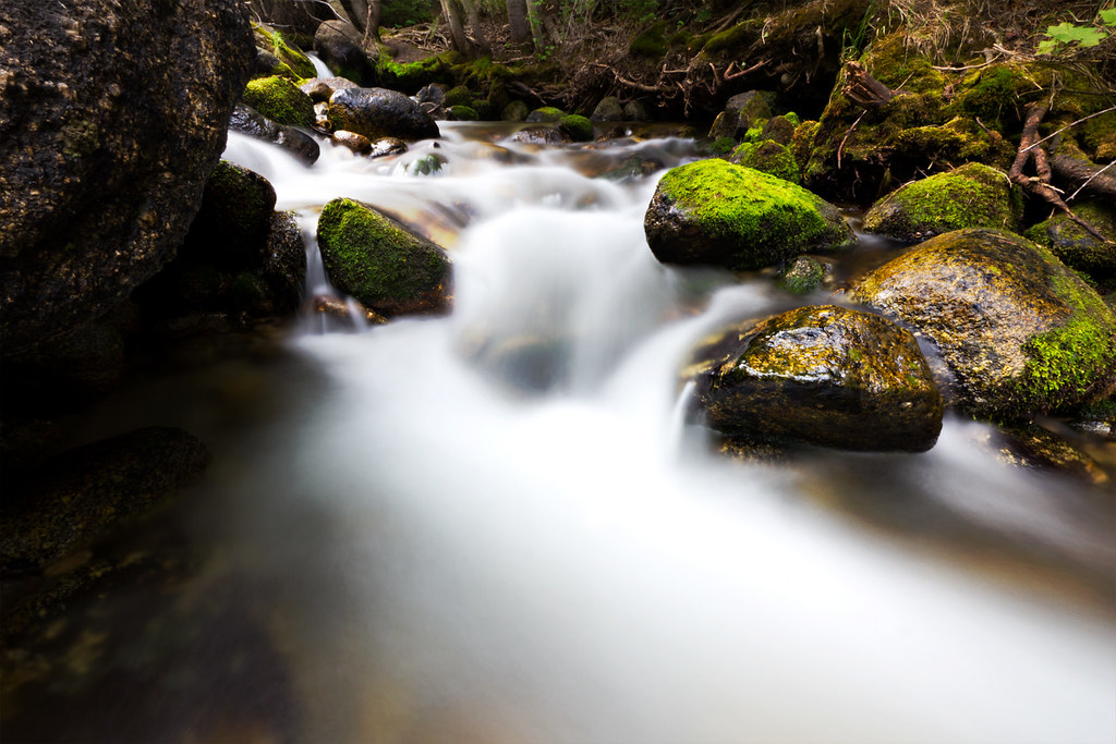
Below the Bridge by ashergrey, on Flickr
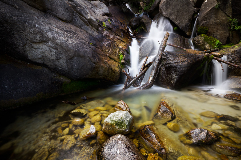
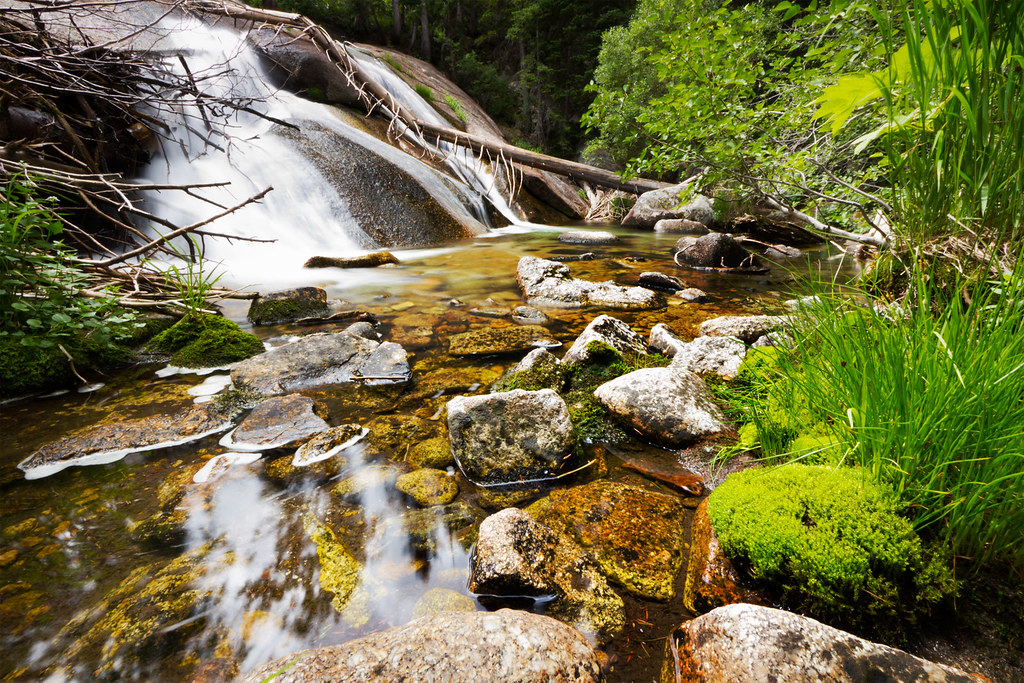
Because Bells is quite steep and rocky, it seems every where you turn there is a photogenic pool or pour-off, surrounded by clumps of moss. The pitch of the trail increases in steady fashion until you reach the lower falls. They cascade down about 40 feet over a granite outcrop, with the water pooling around and spilling between smaller boulders at its base. The entire area is lovely and relatively well maintained, in spite of the mobs of people that visit it.
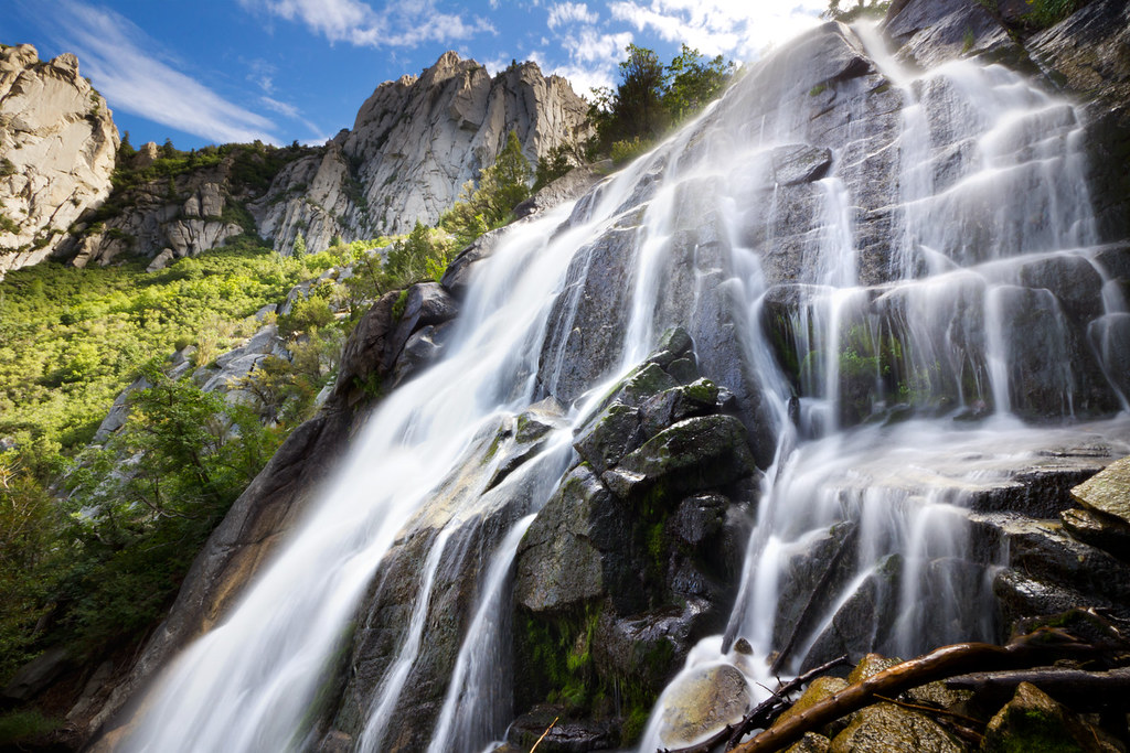
Lower Bells Canyon Falls by ashergrey, on Flickr
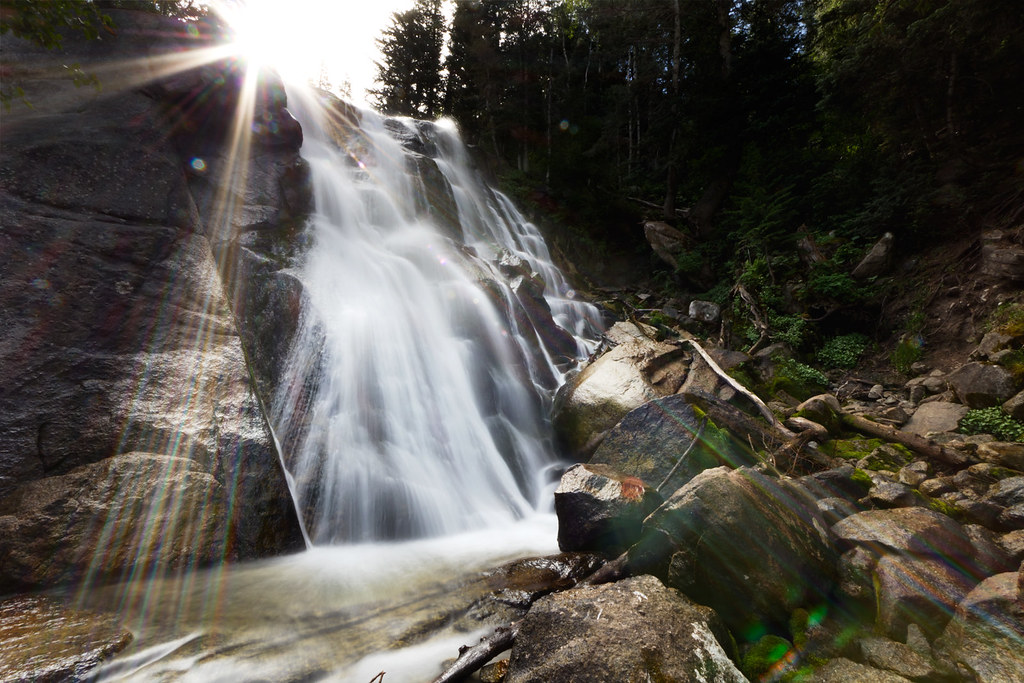
Sunburst at the Lower Falls by ashergrey, on Flickr
Below the Lower Falls by ashergrey, on Flickr
The sun had just started to crest as we moved on from the lower falls. Beyond them, the trail turns into a stair climb over uneven, jutting rocks. We made slow, steady, sweaty progress up through the forest as it transitioned from the bench scrub into solid pine.
In spite of Utah's dry summer, the entire canyon appeared much more lush and green than most other parts of the state… even other sections of the Wasatch. Undergrowth was abundant between the conifers and the trail at times seemed overgrown between the sections where it crosses giant exposed humps of granite.
The air continued to warm and with little breeze, my brother and I were forced to stop and cool off by dunking our heads in the frigid stream. It felt exhilarating to have the blast of cold water coursing across my overheated skin.
Cool Down by ashergrey, on Flickr
The upper falls have been the site of several accidents in recent years, including the fatal fall of Kimberly Evans. Luckily, we were visiting during a low-flow year. The upper falls are still treacherous, but easily crossable when the stream is running low. During runoff periods or a high flow year, the slick, bare rock surface at the top of the falls is a deathtrap.
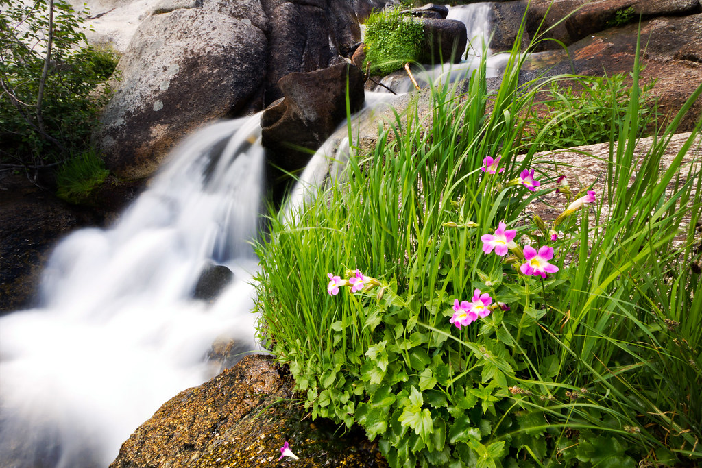
Lewis' Monkeyflower by ashergrey, on Flickr
However, the just above the upper falls are a series of pretty pools and hidden gardens.
Pool by ashergrey, on Flickr
The trail continues its unending climb, moving through some scattered aspens and small meadows full of ferns and wildflowers. Fireweed was, well, on fire at the time of our visit. Paintbrush and other flowers also dotted the landscapes, more so even than in the Albion Basin.
The trail turns south and climbs a series of very steep inclines from here. The tree cover thins or disappears as the terrain becomes more typical of the high-elevation cirques of the central Wasatch. Looking back before making the turn, one can see the spread of the Salt Lake Valley.
Granite by ashergrey, on Flickr
Ascension is far from over at this point, though. Storm cells blew in from the southwest as we hiked up slopes scattered with avalanche-toppled trees and little cairns. Sprinkles of rain fell and the ridgelines disappeared behind a veil of cloud. Still so warm, I opted to leave my rain gear in my pack. This proved to be a wise move, as the thick cloud cover cleared within minutes.
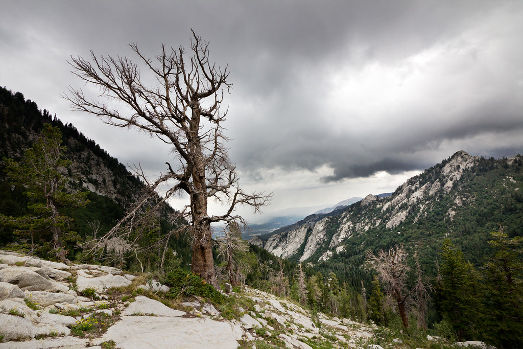
Storm Tree by ashergrey, on Flickr
Above the lower falls, we saw very few people. One of the few was a lone man working his way up the pitches at a snail's pace. He carried an overloaded pack, along with multiple firearms. I did not envy his task. The solitude was nice though. This route felt much more "wilderness", at least above the lower falls, than many other wilderness hikes in the Wasatch.
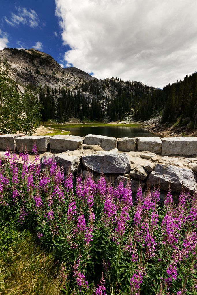
All of that climbing eventually leads to the upper reservoir. It is impounded by a dam built a century ago of hewn granite blocks. Given the effort in the climb, one must admire the fortitude of the crews that engineered and assembled the structure. The problem is, it's now been breached. Still, given the low level of the reservoir at this time, that hardly matters.
Fireweed by ashergrey, on Flickr
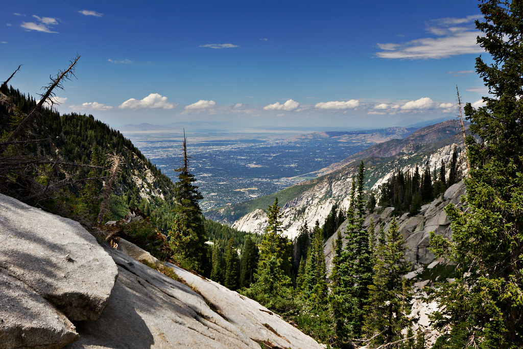
Short on time and energy, we turned back after a few minutes taking in the view. I snapped one last shot from near the reservoir to provide some perspective on the elevation. From where the dam sits at 9,400 feet above sea level, you are higher than Mount Olympus (seen at the right of the frame in the picture below. That's not incredibly high… unless you consider the trail begins just above 5,000 feet. It's a strenuous climb, but one littered with top-notch mountain views.
View from the Top by ashergrey, on Flickr
[PARSEHTML]<iframe src="http://www.mappingsupport.com/p/gmap4.php?q=http://dl.dropbox.com/u/3847512/GPS/Bells_Canyon.kml&t=t4" frameborder="0" marginheight="0" scrolling="no" width="800" height="800"></iframe><br><br>[/PARSEHTML]
Featured image for home page:

The common trail into Bells Canyon begins in the Wasatch foothills at the mouth of Little Cottonwood Canyon. Suburban development has cut off the best approaches into the canyon, so most hikers access it from the Sandy City/Salt Lake County trailhead located near 9600 South Wasatch Boulevard. From here, the trail switches up through gambel oak and sage before crossing south toward lower Bells Canyon Reservoir.
Once at the lower reservoir, the view up into Bells itself is revealed.
Entering Bells Canyon by ashergrey, on Flickr
Bells Canyon is popular with hikers and mountain climbers. The former mostly seek out the lower falls about two miles up while the latter are drawn to the Bell Tower slabs. Bells sits immediately south of Little Cottonwood and ascends toward Lone Peak. It shares much of the same terrain features as trails in Little Cottonwood proper.
My brother and I tackled the climb to Upper Bells Canyon Reservoir on the 24th of July, 2012. We started a bit later than I'd intended, making it on trail sometime between 8:30 and 9 a.m. The morning started cooler than most in Utah's summer, thanks to mostly overcast skies.
Older trip reports on the web speak of numerous stream crossings on improvised log bridges. This does not appear to be the case any longer. A prominent crossing just a few minutes in from the lower reservoir is now made by way of a sturdy constructed bridge. It is here that the highlight of the hike first becomes apparent. Hint: it's the water.
Below the Bridge by ashergrey, on Flickr
Because Bells is quite steep and rocky, it seems every where you turn there is a photogenic pool or pour-off, surrounded by clumps of moss. The pitch of the trail increases in steady fashion until you reach the lower falls. They cascade down about 40 feet over a granite outcrop, with the water pooling around and spilling between smaller boulders at its base. The entire area is lovely and relatively well maintained, in spite of the mobs of people that visit it.
Lower Bells Canyon Falls by ashergrey, on Flickr
Sunburst at the Lower Falls by ashergrey, on Flickr
Below the Lower Falls by ashergrey, on Flickr
The sun had just started to crest as we moved on from the lower falls. Beyond them, the trail turns into a stair climb over uneven, jutting rocks. We made slow, steady, sweaty progress up through the forest as it transitioned from the bench scrub into solid pine.
In spite of Utah's dry summer, the entire canyon appeared much more lush and green than most other parts of the state… even other sections of the Wasatch. Undergrowth was abundant between the conifers and the trail at times seemed overgrown between the sections where it crosses giant exposed humps of granite.
The air continued to warm and with little breeze, my brother and I were forced to stop and cool off by dunking our heads in the frigid stream. It felt exhilarating to have the blast of cold water coursing across my overheated skin.
Cool Down by ashergrey, on Flickr
The upper falls have been the site of several accidents in recent years, including the fatal fall of Kimberly Evans. Luckily, we were visiting during a low-flow year. The upper falls are still treacherous, but easily crossable when the stream is running low. During runoff periods or a high flow year, the slick, bare rock surface at the top of the falls is a deathtrap.
Lewis' Monkeyflower by ashergrey, on Flickr
However, the just above the upper falls are a series of pretty pools and hidden gardens.
Pool by ashergrey, on Flickr
The trail continues its unending climb, moving through some scattered aspens and small meadows full of ferns and wildflowers. Fireweed was, well, on fire at the time of our visit. Paintbrush and other flowers also dotted the landscapes, more so even than in the Albion Basin.
The trail turns south and climbs a series of very steep inclines from here. The tree cover thins or disappears as the terrain becomes more typical of the high-elevation cirques of the central Wasatch. Looking back before making the turn, one can see the spread of the Salt Lake Valley.
Granite by ashergrey, on Flickr
Ascension is far from over at this point, though. Storm cells blew in from the southwest as we hiked up slopes scattered with avalanche-toppled trees and little cairns. Sprinkles of rain fell and the ridgelines disappeared behind a veil of cloud. Still so warm, I opted to leave my rain gear in my pack. This proved to be a wise move, as the thick cloud cover cleared within minutes.
Storm Tree by ashergrey, on Flickr
Above the lower falls, we saw very few people. One of the few was a lone man working his way up the pitches at a snail's pace. He carried an overloaded pack, along with multiple firearms. I did not envy his task. The solitude was nice though. This route felt much more "wilderness", at least above the lower falls, than many other wilderness hikes in the Wasatch.
All of that climbing eventually leads to the upper reservoir. It is impounded by a dam built a century ago of hewn granite blocks. Given the effort in the climb, one must admire the fortitude of the crews that engineered and assembled the structure. The problem is, it's now been breached. Still, given the low level of the reservoir at this time, that hardly matters.
Fireweed by ashergrey, on Flickr
Short on time and energy, we turned back after a few minutes taking in the view. I snapped one last shot from near the reservoir to provide some perspective on the elevation. From where the dam sits at 9,400 feet above sea level, you are higher than Mount Olympus (seen at the right of the frame in the picture below. That's not incredibly high… unless you consider the trail begins just above 5,000 feet. It's a strenuous climb, but one littered with top-notch mountain views.
View from the Top by ashergrey, on Flickr
[PARSEHTML]<iframe src="http://www.mappingsupport.com/p/gmap4.php?q=http://dl.dropbox.com/u/3847512/GPS/Bells_Canyon.kml&t=t4" frameborder="0" marginheight="0" scrolling="no" width="800" height="800"></iframe><br><br>[/PARSEHTML]
Featured image for home page:
")