Navigation
Install the app
How to install the app on iOS
Follow along with the video below to see how to install our site as a web app on your home screen.
Note: This feature may not be available in some browsers.
More options
You are using an out of date browser. It may not display this or other websites correctly.
You should upgrade or use an alternative browser.
You should upgrade or use an alternative browser.
Bowdie Canyon
- Thread starter AWR
- Start date
Thanks, but I'm mainly interested in seeing the big ruin. Just wondering about the route off the rim. Looks easy on GE but you never know.No, but ive been all the way up both forks from the river
The road I'm referring to is the one that heads N from the airstrip. The hike would start from where the road makes a sharp bend to the W.Easy hike from road..... i think you may refering to. Route finding down ledges, dont remember much exposure. Or if you go down the canyon there are other ruins to be seen.
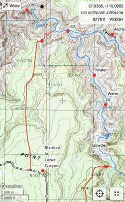
Thanks for the map. Good to know. That's a different route than the one in Kelsey. Kelsey has you coming in E of the small drainage. Around the marked 5600 (56) on the topo. You then work over to the drainage.Something like this. Be safe out there.

Don't like ads? Become a BCP Supporting Member and kiss them all goodbye. Click here for more info.