Info needed: Bown's Canyon, Long Canyon

James and Amy

Member
Joined
Jun 6, 2021
Messages
33
We are considering a trip to the region west of what's left of Hall's Creek Bay, east of the Escalante River, and south of Stevens Canyon down to Lake Powell. We have not found a name for the place, but the SW portion is called Pollywog Bench. We have explored all of Cow Canyon, but nothing else in the area. Does anyone have any beta, in particular access points to Bown's Canyon, and Long Canyon (aka Navajo Creek)?

Thanks, James and Amy
 
Last edited:
We are considering a trip to the region west of what's left of Hall's Creek Bay, east of the Escalante River, and south of Stevens Canyon down to Lake Powell. We have not found a name for the place, but the SW portion is called Pollywog Bench. We have explored all of Cow Canyon, but nothing else in the area. Does anyone have any beta, in particular access points to Brown's Canyon, and Long Canyon (aka Navajo Creek)?

Thanks, James and Amy
This trip report gives some detail on exiting Bown's Canyon from lake level. I seem to recall that one of Steve Allen's books (or Kelsey) talk about the area as well:
There's also some good info here:

Jim
 
Last edited:
Kelsey has quite a lot of info in his "Lake Foul" guide.
 
It's simple to get above the canyons from Bullfrog. Just did that 2 weeks ago. If the potholes still have water (they were at capacity on our trip) then this approach would give a lot more freedom of exploring than entering the bottom end of a couple of relatively short canyons notorious for being hard to exit.
 
It's simple to get above the canyons from Bullfrog. Just did that 2 weeks ago. If the potholes still have water (they were at capacity on our trip) then this approach would give a lot more freedom of exploring than entering the bottom end of a couple of relatively short canyons notorious for being hard to exit.
Did you use packrafts on your trip?
Thanks
 
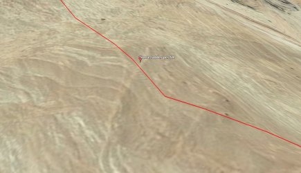
Thank you all for the helpful responses. In my original post I did not make clear that we will be accessing the canyons on an overland trip, not via a boat from the lake. It turns out that I had somehow missed Allen's data when I looked through Canyoneering 3, but taking another page by page look turned it up. He doesn't provide huge detail, but enough to confirm that both canyons to be accessible from the rim. For Bown's, Allen mentions a horse ladder carved into the slickrock. I made a close examination of satellite imagery for the area and believe that I have found the ladder; please see the screenshot below. The ladder is likely the small light lines just below the red track.

Thanks again, James

Bowns Canyon horse steps.jpg
 
Thank you all for the helpful responses. In my original post I did not make clear that we will be accessing the canyons on an overland trip, not via a boat from the lake. It turns out that I had somehow missed Allen's data when I looked through Canyoneering 3, but taking another page by page look turned it up. He doesn't provide huge detail, but enough to confirm that both canyons to be accessible from the rim. For Bown's, Allen mentions a horse ladder carved into the slickrock. I made a close examination of satellite imagery for the area and believe that I have found the ladder; please see the screenshot below. The ladder is likely the small light lines just below the red track.

Thanks again, James

View attachment 119982
Looks good. In the area marked in Kelsey.
 
Thank you all for the helpful responses. In my original post I did not make clear that we will be accessing the canyons on an overland trip, not via a boat from the lake. It turns out that I had somehow missed Allen's data when I looked through Canyoneering 3, but taking another page by page look turned it up. He doesn't provide huge detail, but enough to confirm that both canyons to be accessible from the rim. For Bown's, Allen mentions a horse ladder carved into the slickrock. I made a close examination of satellite imagery for the area and believe that I have found the ladder; please see the screenshot below. The ladder is likely the small light lines just below the red track.

Thanks again, James

View attachment 119982

I can confirm this is a spectacular sheet of slickrock. The slickrock entrance from the west side of Long Cyn is scary and don’t recommend it unless on belay.
 
Similar threads
Thread starter Title Forum Replies Date
Antlerking Indian Creek info needed Trip Planning 4
B Beartooth Lakes Info Trip Planning 1
K Wanting Info on the Cabeza Prieta Game Refuge Trip Planning 11
TeamJenkins17 Red Tops/Needle Creek Drainage Info Trip Planning 0
TeamJenkins17 Looking for info on Clark Creek drainage/Pierpont Pass into Hidden Basin in the Washakie Wilderness Trip Planning 5
A Info on Tehipite Valley Trip Planning 1
seekinglost Desolation Canyon, Utah... Any info? Trip Planning 24
Devin Ashby The Lower Gulch - Escalante (Seeking info on the route) Trip Planning 14
S Washakie: E. Dunoir Creek - Shoshone Pass Info Trip Planning 13
TeamJenkins17 Teton Wilderness Info Trip Planning 10
ADubs Looking for info from anyone who has done the Egypt loop and exited via 25mile wash (Escalante). Trip Planning 3
dhertbag Salt Creek Canyon Info Trip Planning 2
Nick Supporter Renewals with Old Payment Info Questions, Suggestions & Support 6
P Info for The Gulch to Horse Canyon Loop. (canyoneering 3 # 32) Trip Planning 11
swmalone Looking for Info On How to Access Newfoundland Mountains Trip Planning 1
dhertbag Looking for info on Death Hollow Trip Planning 13
Devin Ashby Upper Escalante Canyon / Death Hollow Info? Trip Planning 15
SKLund New Mexico info I have. Noobs: Introduce yourself! 5
Jeremy C NWT Info? Trip Planning 0
Vegan.Hiker Flight cancelled, need last minute info Trip Planning 15
powderglut Starr Springs Campground Info? Trip Planning 6
Kullaberg63 Wasatch peak info Trip Planning 7
BIGHORNtracks Detailed land name info Trip Planning 6
IntrepidXJ Page Photography Info Photography 6
Bob Cedar Mesa - BLM Main Permit, Info Page Resource Discussions 0
uintahiker Tabernacle Hill Lava Tubes- any info? Trip Planning 0
Bigred72 Zion info/shuttle help Meet Up (Members Only) 2
Perry A Bit Off Topic - Prayers Needed General Discussion 69
Titans Pharaoh Lake Wilderness- some much needed Vitamin W Hiking & Camping 5
pstm13 HELP NEEDED- Idaho in Early June for 2-3 Days Trip Planning 6
Upgrayedd Sawtooths Beta needed Trip Planning 2
LarryBoy A week in Zion... Advice needed! Trip Planning 7
KevinBoyer New Cooking Pot Needed. Gear 27
KevinBoyer New Water Filter Needed...Suggestions?? Gear 48
OCArch Suggestion Needed- 4 days in Southern Utah (Escalante?) in Mid-October Trip Planning 11
H suggestion needed: 9-day solo Winds near Elkhart Park Trip Planning 5
T Advice Needed for 5 night Backpack route in Southern Utah Trip Planning 2
Brian Skibbe 200 mile Yellowstone loop in June. Route advice needed. Trip Planning 15
Archbishop I want bag a few peaks. Advice needed. Trip Planning 33
trampalong Mylar and Mylar Bivy Advice Needed Gear 18
Uncle_Dim Wasatch Front Quick Trip Advice Needed Trip Planning 8
W Shuttle Needed from Vernal UT to Leidy Peak - August 6th General Discussion 5
markj Models Needed for Monument Valley Trip Trip Planning 4
mtthwlw Protect the Southwest. Action is needed before November 16. General Discussion 0
A New guy here needed assistance! Noobs: Introduce yourself! 2
fiber Hanksville Shuttle Needed: April 18 from Burr Point to West Rock Canyon Trip Planning 0
steve Maze help needed: Route into Water Canyon from Chimney Rock? Trip Planning 9
mtthwlw 25 mile backpacking trip ideas needed Trip Planning 8
uintahiker Recipe Resource Needed Questions, Suggestions & Support 1
weston Uinta car camping- few spots picked out, help needed! Trip Planning 0

Similar threads

Back
Top