Navigation
Install the app
How to install the app on iOS
Follow along with the video below to see how to install our site as a web app on your home screen.
Note: This feature may not be available in some browsers.
More options
Style variation
You are using an out of date browser. It may not display this or other websites correctly.
You should upgrade or use an alternative browser.
You should upgrade or use an alternative browser.
I have a dream...
- Thread starter Nick
- Start date
- Joined
- Aug 9, 2007
- Messages
- 12,959
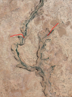
Ah yes... that does look like it could go down there. I'd probably bet on that one more than the upper. Here's a link to those for others:
https://www.google.com/maps/place/37°23'14.6"N 110°51'02.7"W/@37.3870528,-110.8504931,610m/data=!3m1!1e3!4m2!3m1!1s0x0:0x0
Ya know, this route wouldn't be too bad to just come up from Halls Creek and then down Long. That would simplify the shuttle. Just get dropped off by boat in Halls and then picked up 2-3 days later in Long. Looks like about 6-8 miles from HCB to the top of Long. Or I guess you could just go out and back from the mouth of Long, but what fun would that be...
slc_dan
Desert Rat-Weekend Warrior
- Joined
- Jun 7, 2012
- Messages
- 1,687
Ah yes... that does look like it could go down there. I'd probably bet on that one more than the upper. Here's a link to those for others:
https://www.google.com/maps/place/37°23'14.6"N 110°51'02.7"W/@37.3870528,-110.8504931,610m/data=!3m1!1e3!4m2!3m1!1s0x0:0x0
Ya know, this route wouldn't be too bad to just come up from Halls Creek and then down Long. That would simplify the shuttle. Just get dropped off by boat in Halls and then picked up 2-3 days later in Long. Looks like about 6-8 miles from HCB to the top of Long. Or I guess you could just go out and back from the mouth of Long, but what fun would that be...
That would be hella fun to just do as some recon. 1-2 nights.
- Joined
- Aug 9, 2007
- Messages
- 12,959
I explored the east fork of Bowns recently. It seems that it sees very little human traffic nowadays. Good stuff. Posting a link to the TR here for future reference.
http://backcountrypost.com/forum/threads/bowns-canyon.3228/
http://backcountrypost.com/forum/threads/bowns-canyon.3228/
- Joined
- Aug 9, 2007
- Messages
- 12,959
I've been thinking a lot more about this and Dan's To Do post today reminded me of this thread. The west fork of Bowns is definitely going to get some attention from me this year. Kelsey says there is an old cattle trail chipped into the slickrock in the west fork in addition to the known route out the top of the east fork. Might make connecting to something north or west a little easier...
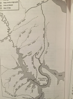
Route lines VERY approximate. I think a night spent in the west fork is looking mandatory at this point. Now it's just a question of whether to do it as an out and back from the bottom of Bowns or a point-to-point. I wish there was a way down into the top of Explorer.

Route lines VERY approximate. I think a night spent in the west fork is looking mandatory at this point. Now it's just a question of whether to do it as an out and back from the bottom of Bowns or a point-to-point. I wish there was a way down into the top of Explorer.

- Joined
- Aug 9, 2007
- Messages
- 12,959
slc_dan
Desert Rat-Weekend Warrior
- Joined
- Jun 7, 2012
- Messages
- 1,687
Here's something for you to think about, @slc_dan. Steve Allen covers this pretty well in Canyoneering 3. He also says there are at least two exits from Long Canyon. One on the west that sounds crazy scary and one on the east that sounds doable. The Pollywog Bench is calling...
That does open some interesting ideas! I was totally thinking of that exit/entrance into Longs on the east we talked about earlier in this thread. There are a whole lot of options depending on how much time we have. Looks like most of the point to point opportunities would be closer to Bullfrog though.
- Joined
- Aug 9, 2007
- Messages
- 12,959
The Forbidding Canyon point-to-point I was thinking about is out of Wahweap, but yeah, most of the longer stuff I want to do is up north. I'm going to move my boat from Wahweap to Bullfrog later this spring and probably leave it there for the foreseeable future. I know it's only like an hour longer, but I have not been loving the drive to the south end.
- Joined
- Aug 9, 2007
- Messages
- 12,959
I think I have a killer point-to-point worked out for the main fork of Bowns and the seven caves. Get dropped off where the old Black Trail leaves the Escalante, spend a night up high on the Pollywog Bench, then drop into Bowns near Cave 2, explore all the caves, then walk down to the head of Long Canyon where the boat and a cooler full of drinks is waiting. 
- Joined
- Aug 9, 2007
- Messages
- 12,959
- Joined
- Aug 9, 2007
- Messages
- 12,959
If timed after a storm, the night on the Pollywog Bench wouldn't even be a dry camp. Just look at all that water up there. Man, I really want to do this...
http://www.flashearth.com/?lat=37.377848&lon=-110.89578&z=18.6&r=0&src=msl
http://www.flashearth.com/?lat=37.377848&lon=-110.89578&z=18.6&r=0&src=msl
- Joined
- Jun 25, 2012
- Messages
- 4,430
I'm in! Wait, where are we going and whom do I have to carry? I guess I better read the thread....I was hoping Art and Merlin could.
Jim Mc
New Member
- Joined
- Nov 8, 2015
- Messages
- 2
I think I have a killer point-to-point worked out for the main fork of Bowns and the seven caves. Get dropped off where the old Black Trail leaves the Escalante, spend a night up high on the Pollywog Bench, then drop into Bowns near Cave 2, explore all the caves, then walk down to the head of Long Canyon where the boat and a cooler full of drinks is waiting.
I have been up on Pollywog Bench twice, but via different access out of Escalante at higher water (3634 feet). Love it up there and want to go back early next spring. Two questions: would the "old black trail leaves the Escalante" be accessible at current Fall 2015 Lake Powell water levels? Is the trail up to Pollywog Bench via "old black trail leaves the Escalante" a walk up steep slickrock with no "airy" narrow ledge precipices? (can't do the airy narrow ledges)
- Joined
- Aug 9, 2007
- Messages
- 12,959
Hey @Jim Mc. Are you talking about this one?
https://www.google.com/maps/place/3...142,1039m/data=!3m2!1e3!4b1!4m2!3m1!1s0x0:0x0
https://www.google.com/maps/place/3...142,1039m/data=!3m2!1e3!4b1!4m2!3m1!1s0x0:0x0
Jim Mc
New Member
- Joined
- Nov 8, 2015
- Messages
- 2
Yes, that is one.Hey @Jim Mc. Are you talking about this one?
https://www.google.com/maps/place/37°18'38.4"N+110°53'26.5"W/@37.310654,-110.8925142,1039m/data=!3m2!1e3!4b1!4m2!3m1!1s0x0:0x0
Don't like ads? Become a BCP Supporting Member and kiss them all goodbye. Click here for more info.

