- Joined
- Mar 11, 2022
- Messages
- 37
Hello everyone,
This 38 mile mostly trailless loop route is located in the Black Ridge Canyons Wilderness area. You can access it via the Mee or Knowles canyon trailheads, which are maybe a 30 minute drive west of Grand Junction. The area is covered in good detail in the Trails Illustrated #502 'Grand Junction Fruita' map, and there is a very short route description in Kelsey's 'Canyon Hiking Guide to the Colorado Plateau' (2006).
The Black Ridge Canyons Wilderness is beautiful and remote - often times it felt more like hiking in Arizona or Utah, than in Colorado. However, lots of bushwacking, route finding, exposed class 2 scrambling, and a class 3 exit out of Mee canyon all make this a very difficult and strenuous canyon hike; a difficulty unfortunately belied by the Kelsey route description. Starting from the Knowles trailhead, I completed the loop clockwise (down Knowles and up Mee) in 4.5 days, generally hiking 8 hrs a day and camping near water sources. Another party I ran into completed the loop in the opposite direction (down Mee up Knowles) in 3.5 days, hiking 10 hrs a day and camped at least 1 night without water. In hindsight, I think doing the loop counter-clockwise would be easier, quicker, and safer than the clockwise route described by Kelsey. With Knowles having less brush, it would definitely be easier to hike down Mee and up Knowles. Plus, hiking down Mee means you can easily lower packs down the class 3 ramp and do the waterless cross-country route between Knowles and Mee with full jugs of water. Anyway, here are some photos from my longer, clockwise loop:

The entrance into upper Knowles. As you can see, there is a pretty good footpath leading down to the creek bed. The creek bed was dry, but if you follow it up canyon through the cottonwoods for about 500 ft, you'll hit a spring and some good camp sites. The colors of the lower Wingate sandstone and upper Entrada were awesome in the late afternoon sun.

Upper Knowles, down canyon from the exit ravine. This part of the canyon was pretty brushy - if you stay downcanyon right you can pick up a fairly good footpath that will take you several miles down canyon. The next reliable water for me was a spring in the creek bed about 2 miles down canyon from the exit ravine, just past a side canyon coming in from the left. After this, there wasn't any reliable water until I hit the Colorado river 7 miles away.

Lower Knowles. At this point the canyon opens up a bit, with the Chinle formation beginning to appear in earnest under the Wingate sandstone. Also, the granite basement rock often appears under the creek bed, making for sections of smooth, brush free walking. It's pretty much cross-country hiking here, alternating between the creek bed and the grassy benches on either side.

Knowles entrance at the Colorado river at sunset. The hoodoo on the right side makes a great landmark if doing the loop from Mee. A mile or two up canyon from the Colorado river, look for a trail that leaves the creek bed to the right. This trail will provide a quick path through all of the brush and lead you to water and the campsites at the river.

The next day saw me hiking along the Colorado river up to the camps at Mee canyon 7 or 8 miles away. This would be a difficult day. Initially the route travels close the the river, then climbs to the top of this 300 ft cliff rising up from the river via two class 2 gullies (hidden behind the grassy hill in the above picture). Thankfully, the route is well cairned through the gullies, but it is still easy to get lost here and get cliffed out. Basically if you are on anything that looks harder than class 2, you are off route. The route ultimately traverses right along the base of the upper cliff band (visible on the right side of the above picture) on this 30+ ft wide sloping brushy ledge system. Class 2 with solid footing (when it is dry), but very airy - I always felt the cliff below me tugging at my heels! Eventually the angle below me relented, allowing me to walk down a grassy hill towards the Moore canyon area.

Desert bighorn sheep in the Moore canyon area

Interesting geology on the way to Mee canyon. Possibly a monocline?

Along the Colorado. The entrance to Mee canyon is visible in the sun, left side of the above picture. You are closer to the river here than the cliffs near Knowles, but this part of the route will burn more calories. I made decent time hiking in the more grassy areas 50 - 100 ft above the river to the unnamed drainage visible in the center of the picture. After the unnamed drainage though, you have to drop lower so that you don't get cliffed out, which means more brush. Also, there are countless rock slides and gullies to navigate through in that area - making for slow, difficult bushwacking. It took me 2+ hrs to get to Mee from the last camps in the Moore area.

Day 4: Lower Mee canyon area. Geology is on full display again here, with the Wingate being carved into some beautiful towers. Apparently, Mee canyon is more popular with the boaters along the river - there was a pretty good trail leading from the Colorado river all the way up to near the 'Y' junction area several miles up. This was a welcome reprieve, after all of that heinous bushwacking yesterday. Unfortunately, I didn't encounter any water until maybe a mile or so below the Y junction.

Unfortunately, the upper part of Mee was much more brushy, trailless, and more difficult to navigate than the lower part. Satellite phones don't work well obviously - also my compass was giving me some strange readings, presumably due to all of the iron in the surrounding walls? There are a lot more side canyons to account for in Mee than in Knowles and it is easy to get disorientated here. I spent close to an hour at the Y junction area, making sure I took the correct branch to the exit ravine and not to somewhere in never never land. I ended up camping about a mile down canyon from the exit ravine (center of above picture) where there was decent water.
The entrance to the exit ravine was not well cairned - I had to do some exploring to find it. But once I found it, the route up was well cairned. There is this exciting class 3 traverse you have to complete near the top of the Wingate sandstone to get to the mesa above. Initially, there are no handholds to speak of and the wall is fairly close to vertical. You have to make some balancey moves, while the exposure gradually increases from 4 to about 30 ft across this traverse. Thankfully, the difficulty eases to class 2 after a few moves - still a very exciting finish! Especially traveling solo, it would have been much easier to lower packs and downclimb this traverse without a pack or rope attached.
Once you reach Mee canyon trailhead, you have another 4-5 miles of cross-country travel to get back to your car at Knowles. There is no established trail between Mee and Knowles trailhead - at this point I had 'had it' with all the bushwacking and had about a quart of water left. So, I waked down to the Rattlesnake road and looked for a ride back to Knowles. Two hitches later, I was back at my car at Knowles, thanks to the incredibly kind and giving locals of the Grand Junction area!
This 38 mile mostly trailless loop route is located in the Black Ridge Canyons Wilderness area. You can access it via the Mee or Knowles canyon trailheads, which are maybe a 30 minute drive west of Grand Junction. The area is covered in good detail in the Trails Illustrated #502 'Grand Junction Fruita' map, and there is a very short route description in Kelsey's 'Canyon Hiking Guide to the Colorado Plateau' (2006).
The Black Ridge Canyons Wilderness is beautiful and remote - often times it felt more like hiking in Arizona or Utah, than in Colorado. However, lots of bushwacking, route finding, exposed class 2 scrambling, and a class 3 exit out of Mee canyon all make this a very difficult and strenuous canyon hike; a difficulty unfortunately belied by the Kelsey route description. Starting from the Knowles trailhead, I completed the loop clockwise (down Knowles and up Mee) in 4.5 days, generally hiking 8 hrs a day and camping near water sources. Another party I ran into completed the loop in the opposite direction (down Mee up Knowles) in 3.5 days, hiking 10 hrs a day and camped at least 1 night without water. In hindsight, I think doing the loop counter-clockwise would be easier, quicker, and safer than the clockwise route described by Kelsey. With Knowles having less brush, it would definitely be easier to hike down Mee and up Knowles. Plus, hiking down Mee means you can easily lower packs down the class 3 ramp and do the waterless cross-country route between Knowles and Mee with full jugs of water. Anyway, here are some photos from my longer, clockwise loop:
The entrance into upper Knowles. As you can see, there is a pretty good footpath leading down to the creek bed. The creek bed was dry, but if you follow it up canyon through the cottonwoods for about 500 ft, you'll hit a spring and some good camp sites. The colors of the lower Wingate sandstone and upper Entrada were awesome in the late afternoon sun.
Upper Knowles, down canyon from the exit ravine. This part of the canyon was pretty brushy - if you stay downcanyon right you can pick up a fairly good footpath that will take you several miles down canyon. The next reliable water for me was a spring in the creek bed about 2 miles down canyon from the exit ravine, just past a side canyon coming in from the left. After this, there wasn't any reliable water until I hit the Colorado river 7 miles away.
Lower Knowles. At this point the canyon opens up a bit, with the Chinle formation beginning to appear in earnest under the Wingate sandstone. Also, the granite basement rock often appears under the creek bed, making for sections of smooth, brush free walking. It's pretty much cross-country hiking here, alternating between the creek bed and the grassy benches on either side.
Knowles entrance at the Colorado river at sunset. The hoodoo on the right side makes a great landmark if doing the loop from Mee. A mile or two up canyon from the Colorado river, look for a trail that leaves the creek bed to the right. This trail will provide a quick path through all of the brush and lead you to water and the campsites at the river.
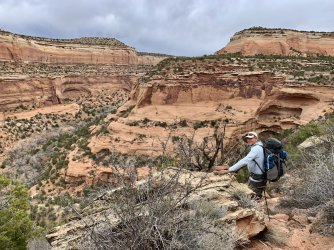
The next day saw me hiking along the Colorado river up to the camps at Mee canyon 7 or 8 miles away. This would be a difficult day. Initially the route travels close the the river, then climbs to the top of this 300 ft cliff rising up from the river via two class 2 gullies (hidden behind the grassy hill in the above picture). Thankfully, the route is well cairned through the gullies, but it is still easy to get lost here and get cliffed out. Basically if you are on anything that looks harder than class 2, you are off route. The route ultimately traverses right along the base of the upper cliff band (visible on the right side of the above picture) on this 30+ ft wide sloping brushy ledge system. Class 2 with solid footing (when it is dry), but very airy - I always felt the cliff below me tugging at my heels! Eventually the angle below me relented, allowing me to walk down a grassy hill towards the Moore canyon area.
Desert bighorn sheep in the Moore canyon area
Interesting geology on the way to Mee canyon. Possibly a monocline?
Along the Colorado. The entrance to Mee canyon is visible in the sun, left side of the above picture. You are closer to the river here than the cliffs near Knowles, but this part of the route will burn more calories. I made decent time hiking in the more grassy areas 50 - 100 ft above the river to the unnamed drainage visible in the center of the picture. After the unnamed drainage though, you have to drop lower so that you don't get cliffed out, which means more brush. Also, there are countless rock slides and gullies to navigate through in that area - making for slow, difficult bushwacking. It took me 2+ hrs to get to Mee from the last camps in the Moore area.
Day 4: Lower Mee canyon area. Geology is on full display again here, with the Wingate being carved into some beautiful towers. Apparently, Mee canyon is more popular with the boaters along the river - there was a pretty good trail leading from the Colorado river all the way up to near the 'Y' junction area several miles up. This was a welcome reprieve, after all of that heinous bushwacking yesterday. Unfortunately, I didn't encounter any water until maybe a mile or so below the Y junction.
Unfortunately, the upper part of Mee was much more brushy, trailless, and more difficult to navigate than the lower part. Satellite phones don't work well obviously - also my compass was giving me some strange readings, presumably due to all of the iron in the surrounding walls? There are a lot more side canyons to account for in Mee than in Knowles and it is easy to get disorientated here. I spent close to an hour at the Y junction area, making sure I took the correct branch to the exit ravine and not to somewhere in never never land. I ended up camping about a mile down canyon from the exit ravine (center of above picture) where there was decent water.
The entrance to the exit ravine was not well cairned - I had to do some exploring to find it. But once I found it, the route up was well cairned. There is this exciting class 3 traverse you have to complete near the top of the Wingate sandstone to get to the mesa above. Initially, there are no handholds to speak of and the wall is fairly close to vertical. You have to make some balancey moves, while the exposure gradually increases from 4 to about 30 ft across this traverse. Thankfully, the difficulty eases to class 2 after a few moves - still a very exciting finish! Especially traveling solo, it would have been much easier to lower packs and downclimb this traverse without a pack or rope attached.
Once you reach Mee canyon trailhead, you have another 4-5 miles of cross-country travel to get back to your car at Knowles. There is no established trail between Mee and Knowles trailhead - at this point I had 'had it' with all the bushwacking and had about a quart of water left. So, I waked down to the Rattlesnake road and looked for a ride back to Knowles. Two hitches later, I was back at my car at Knowles, thanks to the incredibly kind and giving locals of the Grand Junction area!