- Joined
- Aug 9, 2007
- Messages
- 12,950
This is the third in a 3-part trip report from my backpacking trip through Llewellyn Gulch & Cottonwood Gulch in March 2013.
Part 1: Llewellyn Gulch
Part 2: Dos Tinajas
Part 3: Cottonwood Gulch
After 2 days of wandering through the maze of slickrock on the bench between Llewellyn & Cottonwood Gulches, we were pretty excited to drop back into a classic Escalante canyon for our last night of the trip. Flowing water, pools, waterfalls, ruins, rock art... what might we find in this incredibly remote and seldom seen canyon?
The entrance into the canyon was easy once we found it. The book mentioned remnants of a cattle trail but we never noticed it. What we did notice were huge keeper potholes running down the large drainage leading to the canyon bottom. This would have made for an awesome place to practice pothole escapes.

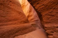
The drainage eventually cut into a shallow slot lined with more deep potholes. We walked to the left down a little gully to reach the canyon bottom.

Upper Cottonwood Gulch is dry so we immediately started heading down canyon. It's awesome to see so few signs of other visitors in these remote places.
Obligatory black and white footsteps in the sand shot.

Not far down canyon, things start to green up a bit and water starts flowing near that shallow alcove in the distance.

Travel in the watercourse becomes very difficult in middle Cottonwood Gulch but thankfully there is a nice bench system that made for easy walking. There were many interesting alcoves along the way. Here is Taylor exploring one that contained some cowboy glyphs from the late 1800's. I didn't check that one out because I had my eye on one right around the corner.

A small ruin site near the previous alcove. There was a bit of rock art nearby but it looked like it was from kids in recent years.

Around this point in the day we wanted to find some shade and chill out for a bit. Unfortunately accessing there wasn't much to be found and the watercourse was very tough to access from up on the bench we were on, so we just headed down canyon until we were shuffled off into the now clear water course, below the high water mark of Lake Foul.
I thought this old cottonwood looked pretty cool spanning the watercourse. The beavers worked hard on that one.

Hiking below the high water mark was kind of depressing. Easy walking but the piles of sediment and the bathtub ring on the slickrock did not make me feel very warm and fuzzy inside.
We walked down to about 40 feet below fool pool before running into some nasty looking beaver dams. We could have gone around but instead we found some shade and relaxed for a couple hours.

After our long break in the shade, we decided we would hike back up canyon, continuing past our entrance point to the head of Cottonwood Gulch to camp. As we were hiking I noticed an insane looking set of moqui steps on the opposite canyon wall. Notice the crack around the middle of the photo. There are steps running all the way to the top there.

A closer view of the moqui steps above

As we were hiking up canyon, I noticed a few small pools in the watercourse below. Interesting because it wasn't choked with willows and russian olive. I walked a little closer to the edge and WOW!!! How did we walk right past this before!?!? It had gotten a little overcast on us but this required another stop!

There were some nice moqui steps to get down to the pool.

It looked so deep that you could probably jump off the cliffs where the water pours in. I'd guess 25 feet or so. Taylor ran down and hopped off a shallow boulder. Sadly, it turned out the water wasn't very deep. A jump off the opposite cliff could have resulted in serious injury as it was mostly just waist-stomach deep. There was one spot that was about neck deep but not very big.

After a quick dip, we continued up canyon. We decided we would dry camp tonight to position ourselves a little better for the hike out in the morning. To avoid carrying tons of water any further than we had to, we walked all the way to the beginning of the flowing water before filling up our reserves.

Back in the dry canyon, approaching the entrance point from earlier in the day. Those are 2 of the 3 'caves' mentioned in Canyoneering 3 that have moqui steps leading into them. It looked insane to even think about trying!

A little further up canyon, the wide open wash turns into an incredible, narrow slot. Going up through the slot involves some climbing. I wasn't sure how my knee (and ankle) were going to handle that, but we had to check it out. For those not wishing (or able) to climb up the slot, it can be easily bypassed by climbing the hill to the left (LUC) that you see in this photo.

The first bend brought what looked like quickmud hell but we were able to skirt around it without sinking.

Around the next bend the slot gave us a show.

The first obstacle was encountered quickly. Not too difficult for climbers or experienced canyoneers, but definitely not easy. Taylor is about half way up in this shot, the bottom is a bit misleading.

Taylor made it up without too much trouble but it took some moves that would be too much for my knee. We got out the handline and sent his pack up. He would continue through the short slot and I would hike up and around.

But I had to snap a few shots on the way out...


The climb around the slot was steep but pretty short and easy. You can literally walk right along the rim of the slot once you're on top.
About half way through, Taylor hit another obstacle that he couldn't get over by himself. I went around to the top to see if I could descend the slot to him and help him up, but there was a drop into a pool of water at the top that I was worried about getting back up, so Taylor had to descend back to the beginning of the slot and take the bypass that I had just taken.

Once past the slot, the canyon opens and we hiked for another 10 or 15 minutes to the top of the canyon where it forks into two slot canyons. We checked some alcoves for potential campsites but decided sleeping on the tarp next to a giant rat's nest didn't sound too appealing so we headed down into the wash and camped right at the junction of the two forks.
You can see our exit route that we would take the next day in this shot. It goes straight up the slickrock in the upper right of the photo across the flat top. It looked kind of impassable from below.

Chilling in our wash camp as the light fades. We were happy, relaxed and feeling totally satisfied by the incredible adventure we had experienced over the last few days.

And then, out of nowhere, a few rain drops... and then more... and then more. It was practically blue skies all around us but the rain wasn't giving up easy. Neither of us had a tent. I didn't even bring a rain jacket. The rain was bitter cold. Taylor of course had rain pants and coat so he hung out in it while I hit underneath our tarp with the gear.

After 15 minutes or so, the rain stopped and the skies cleared. The warmth radiating from the slickrock was gone though, so we bundled up for the night. Mid way through the night, another intense wind storm rolled through, but otherwise it was pretty nice. The soft, sandy surface of the wash bottom made for a very comfortable place to sleep compared to the slickrock the night before.
We woke up with the light in the morning and packed up for the final push out to the truck. I figured we had 3-4 hours of hiking left with the crux right at the beginning: finding our way through the slickrock out of Cottonwood Gulch.
We started by hiking straight up between the two forks from our camp. We were able to keep the route to 3rd class scrambling although it took a bit of scouting to find the best route.
Looking down at upper Cottonwood. I spotted some pretty interesting looking ruins on the hike out (not in this photo) that we had missed the day before. A good reason to return...

Further up the exit

Looking down into the north fork of Cottonwood Gulch. Both forks look like they have some awesome narrows which Steve Allen mentions in his book. We didn't have the time or energy to explore them on this trip.

After cresting over the plateau of the exit point, we dropped back down a bit before we could start hiking up towards Sixty Mile Point and the cattle trail that we would follow back to the truck.

We ended up totally overshooting the cattle trail and ending up almost right at the base of Sixty Mile. After some further scouting we found it, then lost it, then found it. It's a very faint and tough trail to follow out there until you get back to the top of Llewellyn Gulch. As with most of this route, excellent navigation skills are required.

We cooked it pretty fast to get back to the truck and made it there in 3 hours from our camp in Cottonwood. The wind had started kicking up pretty hard so we had a quick celebratory beer and were on our way.
The night before we started hiking, I told Taylor that I felt this trip could be one of the most epic, amazing backpacks I'd ever done. A lot of hype for something that I didn't have much more than a book description to go off. There just aren't a lot of photos of this place to be found. But the hype was well deserved. My GPS only logged about 28 miles (felt like 40) but it was some of the best I've ever put down.
Part 1: Llewellyn Gulch
Part 2: Dos Tinajas
Part 3: Cottonwood Gulch
After 2 days of wandering through the maze of slickrock on the bench between Llewellyn & Cottonwood Gulches, we were pretty excited to drop back into a classic Escalante canyon for our last night of the trip. Flowing water, pools, waterfalls, ruins, rock art... what might we find in this incredibly remote and seldom seen canyon?
The entrance into the canyon was easy once we found it. The book mentioned remnants of a cattle trail but we never noticed it. What we did notice were huge keeper potholes running down the large drainage leading to the canyon bottom. This would have made for an awesome place to practice pothole escapes.
The drainage eventually cut into a shallow slot lined with more deep potholes. We walked to the left down a little gully to reach the canyon bottom.
Upper Cottonwood Gulch is dry so we immediately started heading down canyon. It's awesome to see so few signs of other visitors in these remote places.
Obligatory black and white footsteps in the sand shot.
Not far down canyon, things start to green up a bit and water starts flowing near that shallow alcove in the distance.
Travel in the watercourse becomes very difficult in middle Cottonwood Gulch but thankfully there is a nice bench system that made for easy walking. There were many interesting alcoves along the way. Here is Taylor exploring one that contained some cowboy glyphs from the late 1800's. I didn't check that one out because I had my eye on one right around the corner.
A small ruin site near the previous alcove. There was a bit of rock art nearby but it looked like it was from kids in recent years.
Around this point in the day we wanted to find some shade and chill out for a bit. Unfortunately accessing there wasn't much to be found and the watercourse was very tough to access from up on the bench we were on, so we just headed down canyon until we were shuffled off into the now clear water course, below the high water mark of Lake Foul.
I thought this old cottonwood looked pretty cool spanning the watercourse. The beavers worked hard on that one.
Hiking below the high water mark was kind of depressing. Easy walking but the piles of sediment and the bathtub ring on the slickrock did not make me feel very warm and fuzzy inside.
We walked down to about 40 feet below fool pool before running into some nasty looking beaver dams. We could have gone around but instead we found some shade and relaxed for a couple hours.
After our long break in the shade, we decided we would hike back up canyon, continuing past our entrance point to the head of Cottonwood Gulch to camp. As we were hiking I noticed an insane looking set of moqui steps on the opposite canyon wall. Notice the crack around the middle of the photo. There are steps running all the way to the top there.
A closer view of the moqui steps above
As we were hiking up canyon, I noticed a few small pools in the watercourse below. Interesting because it wasn't choked with willows and russian olive. I walked a little closer to the edge and WOW!!! How did we walk right past this before!?!? It had gotten a little overcast on us but this required another stop!
There were some nice moqui steps to get down to the pool.
It looked so deep that you could probably jump off the cliffs where the water pours in. I'd guess 25 feet or so. Taylor ran down and hopped off a shallow boulder. Sadly, it turned out the water wasn't very deep. A jump off the opposite cliff could have resulted in serious injury as it was mostly just waist-stomach deep. There was one spot that was about neck deep but not very big.
After a quick dip, we continued up canyon. We decided we would dry camp tonight to position ourselves a little better for the hike out in the morning. To avoid carrying tons of water any further than we had to, we walked all the way to the beginning of the flowing water before filling up our reserves.
Back in the dry canyon, approaching the entrance point from earlier in the day. Those are 2 of the 3 'caves' mentioned in Canyoneering 3 that have moqui steps leading into them. It looked insane to even think about trying!
A little further up canyon, the wide open wash turns into an incredible, narrow slot. Going up through the slot involves some climbing. I wasn't sure how my knee (and ankle) were going to handle that, but we had to check it out. For those not wishing (or able) to climb up the slot, it can be easily bypassed by climbing the hill to the left (LUC) that you see in this photo.
The first bend brought what looked like quickmud hell but we were able to skirt around it without sinking.
Around the next bend the slot gave us a show.
The first obstacle was encountered quickly. Not too difficult for climbers or experienced canyoneers, but definitely not easy. Taylor is about half way up in this shot, the bottom is a bit misleading.
Taylor made it up without too much trouble but it took some moves that would be too much for my knee. We got out the handline and sent his pack up. He would continue through the short slot and I would hike up and around.
But I had to snap a few shots on the way out...
The climb around the slot was steep but pretty short and easy. You can literally walk right along the rim of the slot once you're on top.
About half way through, Taylor hit another obstacle that he couldn't get over by himself. I went around to the top to see if I could descend the slot to him and help him up, but there was a drop into a pool of water at the top that I was worried about getting back up, so Taylor had to descend back to the beginning of the slot and take the bypass that I had just taken.
Once past the slot, the canyon opens and we hiked for another 10 or 15 minutes to the top of the canyon where it forks into two slot canyons. We checked some alcoves for potential campsites but decided sleeping on the tarp next to a giant rat's nest didn't sound too appealing so we headed down into the wash and camped right at the junction of the two forks.
You can see our exit route that we would take the next day in this shot. It goes straight up the slickrock in the upper right of the photo across the flat top. It looked kind of impassable from below.
Chilling in our wash camp as the light fades. We were happy, relaxed and feeling totally satisfied by the incredible adventure we had experienced over the last few days.
And then, out of nowhere, a few rain drops... and then more... and then more. It was practically blue skies all around us but the rain wasn't giving up easy. Neither of us had a tent. I didn't even bring a rain jacket. The rain was bitter cold. Taylor of course had rain pants and coat so he hung out in it while I hit underneath our tarp with the gear.
After 15 minutes or so, the rain stopped and the skies cleared. The warmth radiating from the slickrock was gone though, so we bundled up for the night. Mid way through the night, another intense wind storm rolled through, but otherwise it was pretty nice. The soft, sandy surface of the wash bottom made for a very comfortable place to sleep compared to the slickrock the night before.
We woke up with the light in the morning and packed up for the final push out to the truck. I figured we had 3-4 hours of hiking left with the crux right at the beginning: finding our way through the slickrock out of Cottonwood Gulch.
We started by hiking straight up between the two forks from our camp. We were able to keep the route to 3rd class scrambling although it took a bit of scouting to find the best route.
Looking down at upper Cottonwood. I spotted some pretty interesting looking ruins on the hike out (not in this photo) that we had missed the day before. A good reason to return...
Further up the exit
Looking down into the north fork of Cottonwood Gulch. Both forks look like they have some awesome narrows which Steve Allen mentions in his book. We didn't have the time or energy to explore them on this trip.
After cresting over the plateau of the exit point, we dropped back down a bit before we could start hiking up towards Sixty Mile Point and the cattle trail that we would follow back to the truck.
We ended up totally overshooting the cattle trail and ending up almost right at the base of Sixty Mile. After some further scouting we found it, then lost it, then found it. It's a very faint and tough trail to follow out there until you get back to the top of Llewellyn Gulch. As with most of this route, excellent navigation skills are required.
We cooked it pretty fast to get back to the truck and made it there in 3 hours from our camp in Cottonwood. The wind had started kicking up pretty hard so we had a quick celebratory beer and were on our way.
The night before we started hiking, I told Taylor that I felt this trip could be one of the most epic, amazing backpacks I'd ever done. A lot of hype for something that I didn't have much more than a book description to go off. There just aren't a lot of photos of this place to be found. But the hype was well deserved. My GPS only logged about 28 miles (felt like 40) but it was some of the best I've ever put down.