Coyote Gulch to Lake Powell

DSlip

New Member
Joined
Dec 7, 2020
Messages
2
Hello everyone,

First time poster here, and you all seem the most knowledgeable group for this question:

I am planning a packrafting trip for next year and I found several good resources on this forum for packrafting to Coyote Gulch, long backpacking trips starting from Coyote Gulch, and packrafting trips entering/exiting from downstream canyons (Willow/Fortymile/Fiftymile/Davis) but nothing from Coyote Gulch to these downstream canyons. Obviously the low lake levels will leave a lot of silt and other undesirable remnants behind, and there will be more hiking to reach the lake, but is anyone aware of a reason why this loop would be problematic?

Thank you for your help!
 
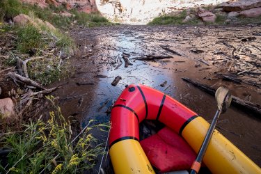
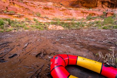
The transition zone between the lake and the river can be very unpredictable. Sometimes you can float right in, and other times you'll run into an endless sea of debris that can be a real problem to get through. In this delta area the flow is often too shallow to float through even if it's free of debris, but the quicksand is too sticky and deep to walk through. It can be the full width of the canyon and miles long. Typically if the lake has been on the rise, you can float or walk on firm ground until it's deep enough but you still might have to battle some debris fields. But if the lake has been dropping, you are more likely to encounter a dangerous situation where you can't walk or float.
 
Am I on the wrong page or are there just 3 comments on there from 2011 or earlier?
Correction: it was under Reports

Steven Bollock wrote:
'The put-in is easy; the take-out is either an expensive tow or a fairly brutal hike. It requires a very flexible calendar to catch the usually very short window of opportunity (most commonly mid April to early May). I think its about 75-80 miles. We spent 8 nights last time and I'd do more this year if it happened. IK's are the ideal craft as one is in and out of the boat fairly frequently. There is an abundance of side canyon exploration. It is a very small river with mostly small camps and lends itself to small groups. In places the river is lined with nasty Russian Olive trees which have large thorns. Flimsy duckies are not recommended. I've heard various things about water levels. 50 cfs and rising would be minimally desirable. 300 cfs will have you up in the Russian Olives along the banks. I have been told it is really a drag to get stuck out there when the water disappears (i.e. the end of the season's flow). There is one easy portage; one runnable difficult rapid (easily lineable). It's a great trip with lots of pictographs and ruins to look for. If you find anyone who can provide a tow to Bullfrog Marina please let me know. When we went several years ago a tow was $600. A car shuttle from the put-in to the marina is $300 (2010 price). If one hikes out through 'Crack-in-the wall' at Coyote Gulch (3 miles, one of which goes steeply up through sand) the shuttle costs are much less.”
 
I think that's pretty old too (he mentions 2010 pricing). There's not much russian olive left down there and I haven't heard of anyone successfully getting a commercial pickup in the lake for a very long time. There isn't anyone licensed doing it anymore, at least not as of a few years ago. I would just caution anyone going off of old data for that endeavor as it does change wildly even during the same year. But on the upside, packrafters usually get the benefit of hitting the lake while water is rising which cuts down on the quicksand problem that manifests itself as the water drops. The debris log jams are a whole different story though.
 
I think that's pretty old too (he mentions 2010 pricing). There's not much russian olive left down there and I haven't heard of anyone successfully getting a commercial pickup in the lake for a very long time. There isn't anyone licensed doing it anymore, at least not as of a few years ago. I would just caution anyone going off of old data for that endeavor as it does change wildly even during the same year. But on the upside, packrafters usually get the benefit of hitting the lake while water is rising which cuts down on the quicksand problem that manifests itself as the water drops. The debris log jams are a whole different story though.
Yeah I've done it a few times and basically as long as you're up for some potential serious suffering it's doable. Unless you encounter conditions where it isn't. Basically as long as you're willing to somehow bail yourself out and are experienced in the kind of backcountry travel that might be your backup it might be worth considering but there's good reason there isn't a bunch of info out there of people doing it. _DSC8263.jpg_DSC8264.jpg
 
Yeah, that's what I'm talking about. I've seen that stuff out there where the canyon is much wider and it still goes around multiple bends. And there's not always shoreline to walk on down lower where it's silted in. It's stopped us in our tracks on numerous attempts to hike a canyon (not just the Escalante itself). Although I did score a free tandem whitewater ducky out of it once!
 
Thank you for all of the input! We will check conditions closely and make a judgment call based on lake levels and the flow rate in the Escalante. We’ll be hitting it at the prime season early to mid May, so depending on snowpack and temperature changes we may get lucky enough to give it a go, or we may have to switch to an alternative.

If anyone can arrange for perfect conditions, though, it would be greatly appreciated.
 
Back
Top