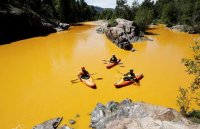
Animas River Disaster

They definitely did, but I don't think it's fair that people are raging on the EPA and not the fact that the extraction industry leaves this crap behind after everything goes bust. The toxic stew was already leaking into the river, just at lower levels. They were just trying to stop it and an accident happened. I blame the lack of regulation in the first place.
 
On the bright side, the 3-month outlook is calling for much higher than average precip over SW Colorado. Maybe that'll help push it down into Powell a little faster. I wonder what that sediment drop is going to be like when the lake drops.
 
Mmmmmm...river Tang.
That's class V flatwater right there. Don't flip.
 
Sad day for the folks in Durango and downstream from the mines. I am sure that the impact on the river will be felt for years and hopefully will drive the EPA to declare the mine are a Superfund site. I think that Silverton has resisted them doing that because of the potential impact to tourism.

To me it sounds like the water had been leaking out of these mines and into the creek for sometime, just at much smaller amounts. Sounds like the EPA broke the retention pond wall or something.

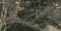
A quick google maps search shows this:

upload_2015-8-8_3-51-35.png

The flag is the mine that had the spill, look to the West.

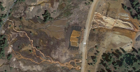
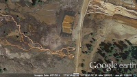
upload_2015-8-8_4-18-4.png

I would guess these photos were taken not to recently. Looks like this has been a problem for a while, only being addressed because enough entered the stream at once to change the color.
 
This is a disaster. I have fished this fantastic, clear river for rainbows and browns, swam in it and watched kids jumping off low bridges and rafters floating along and taking in the incredible scenery. Some of the stretches are gold medal fisheries. I wonder how this will affect the river's future.

Durango must be reeling and all those iconic places downstream...scary...
 
Utah Departments of Environmental Quality and Health say the contaminants are in the state, but shouldn't threaten recreational or agricultural users in the short-term:

The Utah Department of Health (DOH) reviewed DEQ’s data collected on August 10, 2015 and prepared a Statement of Evaluation for these data.
The data showed that for public use, six contaminants exceeded screening values: aluminum, arsenic, barium, iron, lead, and manganese. For each contaminant identified above the screening level, a 95 percent upper confidence limit (95% UCL) was calculated. This value represents with 95 percent confidence that it is above the true average concentration for the contaminant in the environment that is being sampled and more accurately depicts what a person will come into contact with rather than simply using a simple average or a maximum value.
After calculating the 95% UCL, this value is compared to the health-based screening values. If it falls below the screening value, no further exposure investigation is warranted. For this data set, the 95% UCL for barium fell below screening levels and was not evaluated further.
The five remaining contaminants that exceeded screening levels were evaluated for recreational exposures. DOH defines a standard recreational exposure as 60 days of exposure per year for two hours a day. It considers skin contact and accidental ingestion of river waters during recreation of 50 mL per hour.
None of the contaminants exceeded screening values for agricultural use.
Based on these data, DOH does not expect that recreational or agricultural use of the San Juan River will result in adverse effects in people, livestock, or crops. It is still recommended that recreational users carry their own drinking water and not rely on filtering or purifying river waters. Further evaluations and updated findings will be provided as new data become available.
Long-term Impacts
DEQ scientists are evaluating the potential long-term risk to Utah’s waters from the release of more than two million pounds of toxic metals into the Animas River. A number of factors mitigate the effects of the spill in Utah, and these factors help explain why the levels of metals in Utah have been difficult to link directly to the spill:
  • The underlying chemistry in western streams creates conditions that cause most metals to settle from the water or otherwise be retained upstream. The chemical environment of these rivers should cause iron—about 85 percent of the metals that were released in the spill—to settle relatively quickly.
  • Alkaline conditions in the Animas and San Juan Rivers and the large quantities of sediment that move through these systems mean the metals are likely to remain attached to particles and not pose acute risks to aquatic life or people.
  • The total volume of water released constitutes less than 1 percent of the daily flow in the San Juan River. The relative threat of exposure to toxic metals diminishes as these metals become diluted and dispersed in the water.
  • The higher flows in the San Juan River, due to the size of the river and intentional releases from Navajo Dam following the mine discharge, should help reduce exposure to the toxins released from the Gold King Mine. Recent storms in southern Utah further reduced any immediate threats.
  • The San Juan River carries large amounts of sediment downstream, which should help bury any metals that make it to Lake Powell, minimizing the potential for these substances to negatively affect the fish and other wildlife that use the lake.
Once these metals have settled, DEQ will begin evaluating the long-term impacts to Utah’s San Juan River and Lake Powell and will partner with other agencies to develop long-term monitoring plans.

Info from http://www.deq.utah.gov/Topics/Water/goldkingmine/index.htm.
 
Utah, Colorado, and the Navajo Nation are all weighing lawsuits against the EPA now. I wonder how much of the blame should rest on Silverton and Durango, they have been resisting the EPA cleanups because for the stigma a Superfund site would cause.
 
Similar threads
Thread starter Title Forum Replies Date
Nurrgle Don't Fret Utah Friends, The Animas River is Safe General Discussion 2
BJett San Juan River - Sand Island to Clay Hills On The Water 0
D Wind River-like Zone in Canada Backpacking 5
M Lost a drone in the San Rafael River area/below the wedge. No time to hike in to retrieve. General Discussion 0
fossana Colorado River talks in Springdale, UT (March 27th, April 5th) General Discussion 6
TractorDoc Yellowstone's Gallatin River -- September 7-9th 2023 Backpacking 12
BJett Rockcastle River No Shuttle Packrafting - Kentucky On The Water 2
Janice Such a GRAND Canyon - Deer Creek / Tapeats / Thunder River Backpacking 21
Kullaberg63 Suggestions for Escalante east of river, south of Choprock Trip Planning 4
scatman The Gallatin River, Bighorn and Fawn Passes, Yellowstone National Park - September 7, 2023 Backpacking 14
shredhiker Thorofare, Heart Lake, Snake River Sept. 2023 Backpacking 16
Ugly Headless Valley- Film about traveling the Nahanni River General Discussion 5
meowtaingal Wind river high route mid september Trip Planning 7
BJett Packrafting the Obed National Wild & Scenic River - Tennessee On The Water 1
kwc Savage River, Denali NP Hiking & Camping 1
D Wind River offtrail route questions Trip Planning 28
Rockskipper You think you found a pithouse, or maybe an Ancestral Puebloan tower near Green River, UT? It's maybe something even more interesting... General Discussion 3
SteveR Sheep River Road Ride on May Day Everything Else 2
F Upper Escalante River Backpack conditions Trip Planning 6
W Greetings from the West Side of the Winds (Wind River range) Noobs: Introduce yourself! 5
marquiri Wind River Range - Angel Pass Trip Planning 24
Writhdar Day hikes in the White Clouds and Lost River Range Hiking & Camping 1
BJett Packrafting the Cumberland River Below the Falls - Kentucky On The Water 6
Mikjik86 Backpacking The Wind River Range - Wyoming, September 2022 Trip Reports 3
kwc Cedar River Flow, Central Adirondacks On The Water 1
kwc Fall paddle on the West Branch of the Sacandaga River 10/23/22 On The Water 0
Jackson Heart Lake and Snake River for Labor Day Backpacking 23
Stephanie B Dirty Devil River Impassible at Poison Springs Canyon Off Road 0
R Wind River Range: Green River Lakes/Clarks Trail/Porcupine Creek Trail Trip Planning 3
BJett Amazing Appalachians - Backpacking/Packrafting the AT and Nantahala River Backpacking 5
Georgia Yankee Snake River; Wolverine, Coulter, Pilgrim Creeks, July-Aug. 2022 Backpacking 18
Mikjik86 Another Wind River Trip Planning! Elkhart/Titcomb/Knapsack/Shannons Pass loop back to Elkhart, or continue to Green River Lakes Trailhead? Trip Planning 10
wsp_scott Wind River Range Sept 2021 (part 2) Backpacking 4
wsp_scott Wind River Range Sept 2021 (part 1) Backpacking 16
WasatchWill WRHR - Day 7: Beaver Park to Green River Lakes Backpacking 15
BJett Big South Fork National River & Recreation Area Packraft/Backpack Loop (TN) Backpacking 6
BJett Red River Gorge/Red Byrd Arch Packraft Trip - Kentucky Hiking & Camping 9
scatman Gila River - Gila Wilderness, New Mexico - April 18, 2022 Backpacking 61
B Wind river range mid sept. Trip Planning 8
andyjaggy Wind River Range Roberts Mountain Trip Planning 4
Rockskipper Application Period Open For 2023 Private River Trips Through Grand Canyon National Park General Discussion 0
marquiri Wind River Range - September 2022 Trip Planning 31
P Yellowstone Snake River weekend Backpacking 7
TheMountainRabbit Northern Wind River Traverse (Bridger/Fitzpatrick Wilderness) - September 2021 Backpacking 16
scatman North Pitchstone Trail, Headwaters of Ouzel Creek, Bechler River and Mr. Bubbles(?) - Yellowstone National Park - September 13, 2021 Backpacking 36
stretch Grand Canyon Loop: Thunder River -> Tapeats -> Kanab -> Sowats Backpacking 22
Janice Cosmic Ashtray via Wolverine/Little Death Hollow & Escalante River? Trip Planning 16
scatman Snake River Lollipop Loop - Yellowstone National Park - August 8, 2021 Backpacking 45
Noun Sequitur Jemez River, Las Conchas Trail and Beyond Hiking & Camping 1
D Wind River Blowdown Trip Planning 2

Similar threads

Back
Top