danger02ward
Love the Mountains!
- Joined
- Mar 1, 2016
- Messages
- 402
Before: Grand Canyon south rim loop. Down south kaibab and up bright angel.
Follow along with the video below to see how to install our site as a web app on your home screen.
Note: This feature may not be available in some browsers.

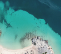
"Everything Else" category?This one most definitely won't get a trip report since it will almost completely consist of soaking in clear blue Caribbean waters while free cocktails are delivered
View attachment 48571
I mean, you could certainly take a "trip" on your vacation... but we can't encourage that here"Everything Else" category?

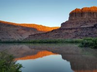
After: I canoed Labyrinth Canyon from Ruby Ranch to Mineral Bottom, putting in Thursday morning and taking out Sunday. The water flow upstream at the town of Green River quadrupled while my group was on the river (probably due mostly to a contribution from the Price River, which jumped from 3 cfs up to over 8,000 cfs), and we woke up on Friday morning with tents in the river and three canoes missing. It was a rough morning but we were able to recover the canoes and continue with the trip, which turned out to be pretty darn great.

After: I canoed Labyrinth Canyon from Ruby Ranch to Mineral Bottom, putting in Thursday morning and taking out Sunday. The water flow upstream at the town of Green River quadrupled while my group was on the river (probably due mostly to a contribution from the Price River, which jumped from 3 cfs up to over 8,000 cfs), and we woke up on Friday morning with tents in the river and three canoes missing. It was a rough morning but we were able to recover the canoes and continue with the trip, which turned out to be pretty darn great.
View attachment 48587
I respectfully beg for a trip report.....After: I canoed Labyrinth Canyon from Ruby Ranch to Mineral Bottom, putting in Thursday morning and taking out Sunday. The water flow upstream at the town of Green River quadrupled while my group was on the river (probably due mostly to a contribution from the Price River, which jumped from 3 cfs up to over 8,000 cfs), and we woke up on Friday morning with tents in the river and three canoes missing. It was a rough morning but we were able to recover the canoes and continue with the trip, which turned out to be pretty darn great.
View attachment 48587
We just had them beached. The group made several mistakes that could have had some serious consequences: not camping high enough above the river to account for even a moderate rise in water level; not tying the boats up; and not voicing misgivings. After the fact, almost everyone in the group said they weren't really comfortable with our choice of camp spots, but nobody said anything at the time.That is so crazy man. Did you guys just have the canoes beached or were they tied up/anchored? I can't believe how far you paddled back up with them! Looking forward to the full report!

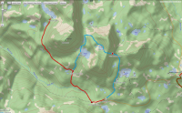
BEFORE: Heading into the Cuberant Basin on Sunday....
View attachment 48887
Planning on heading into the basin first. If conditions allow I might try to summit Mt Marsell. If I have time on the way out I'd like to take the Lofty Lake trail back to the Pass Lake trail head. Weather is looking really good... excited to go!

Before: Heading to The Maze again this weekend. This time around it's a mountain bike trip with 4WD support. Going to spend a night at the Maze Overlook and another over at The Wall. If anyone knows of anything cool I shouldn't miss, let me know. I've camped in the Land of Standing Rocks, The Dollhouse, and down in the Maze and I've also hiked up to the Maze Overlook, but I've never driven between Flint and the Overlook before.
The hike out to the Chocolate Drops from The Wall is pretty great. Highly recommended.
Don't like ads? Become a BCP Supporting Member and kiss them all goodbye. Click here for more info.
