Uintas Conditions 2013

Nick

-
.
Joined
Aug 9, 2007
Messages
12,949
Thought I'd get a post going on 2013 Uintas Conditions. I was just doing some trip planning and am loving the sat images for the Uintas on Flash Earth. Anyone seen them? Much better res than google earth and they took them at the sweet spot of snow melt. That perfect time of the year where you can pack in some beer and bury it in the snow right next to your nice, dry campsite. :) So when will that time of year be this year?
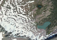
Screen Shot 2013-04-24 at 11.00.55 PM.png

http://www.flashearth.com/?lat=40.746075&lon=-110.67655&z=16.2&r=0&src=msl

So if you hear any updates on snow levels and access to the Uintas this spring, post 'em here. Still a bit early but I imagine with the warm up coming it's going to start melting fast. I did my first Uintas backpack last year on May 12th. Just a bit longer than 2 weeks from now, and I'm thinking this year was drier.

http://backcountrypost.com/forum/threads/uintas-north-fork-trail.822/

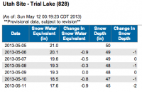
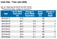
Current Trial Lake snotel snow depth reading:
Screen Shot 2013-04-24 at 10.57.53 PM.png

http://www.wcc.nrcs.usda.gov/reportGenerator/beta/view/customSingleStationReport/daily/828:ut:SNTL|id=""|name/-7,0/WTEQ::value,WTEQ::delta,SNWD::value,SNWD::delta
 
On the KSL website it is showing that the Uintas are are 142% snow pack for this time of year, which on their maps would represent the dead horse lake area (http://www.ksl.com/index.php?sid=134181&nid=149). For the southern region it is at 103% of normal. There is also a web cam at Moon Lake Resort that shows the snow pretty well on the southern slopes if any one is interested in following it a bit (http://www.webcams.travel/webcam/1355147007-Weather-High-Uintas-Wilderness-Moon-Lake-Resort).
 
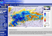
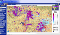
Uh.. You know about the Snow Model, right? This NOAA site has a model of the snowpack that comes from direct snow coverage imagery from space and then ground-truthed with SnoTel and other sources on the ground. It then forecasts five days forward using the NWS forecast. It is a real time model and the model is adjusted weekly or more often based on ground observations. Nick, I know you are a usability guy. This is not the most usable site but it is, by far, the best and most current snow on the ground forecast I know of. This link is to the current model of the snow depth departure from normal for the Uintahs. How much below or above average we are. Check out the dropdowns on the left for all the parameters you can map. Wild. Important. Enjoy.

Poke around there a little. Or a lot.
Screen Shot 2013-05-03 at 1.37.37 PM.png
 
You can also download KML files to overlay that NOAA information in Google Earth, FYI.
 
I drove up the mirror lake highway Sunday May 5th. Road was completely snow free to Murdock Basin turnoff, roughly mile 20. There was a sign on the road saying it was closed, but there were dozens of cars passing it. Snow started to cover the road shortly thereafter, but it would be a pretty easy plow. Crystal lakes will be accessible this week, if I had a guess.

I am confident hwy 150 will be open this year before memorial day, just like last year.
 
My brother flew over the Uintas today and says the high terrain still appeared completely snow-covered.
 
i need to get a tutorial on how those graphs work. the snow depth dropped 10 percent, but snow water equivalent is down almost 20 percent?

if this heat keeps up, it's gonna come off quick.
 
Time to turn on the A/C at my house in SLC.

Man, I turned my A/C on three weeks ago :)

And now I'm down in southern Georgia enjoying the beach. But don't worry...it's all work!

I think it will be hotter in SLC tomorrow than it will be here. I'm going to check out Christmas Meadows this weekend when I get back to see what the snow looks like.
 
Man - I have not been to this site for a while. Time to get back at it.

I love all the technology, but I only live a few minutes drive from the Uintas and have been watching/looking closely. The Mirror Lake highway gate on the North Slope is open, but you can only get to the Hayden Campground as of Saturday. I went hiking near the ranger station and tons of snow drifts everywhere. The highway will not be open over the top for a while. Sunday I drove to the Henry's Fork Trailhead - lot of snow, no hiking without snow shoes for a while. For all the talk of drought, the Uintas - especially the Eastern side - had a slightly above average year and with this real cool spring, it will be later than average to getting in the high country. After this heat spell, the forecast calls for more cool temperatures, so the snow pack will likely linger.
Thanks for the update. I was just logging on to ask if anyone had been in from the Evanston side...that news is killing me. I just sat around looking at my gear sunday evening and was telling myself its only a matter of weeks now. We'll see.
 
So, does anyone think a backpacking trip is possible in the Uintas this coming Memorial Day weekend? Mirror Lake Highway is supposed to be open from the Evanston side to just past Beaver View campground. UDOT has no estimate on opening the highway yet. I'm thinking it might be possible to come in from the north as far as I can drive, then hike into the Ruth Lake area, but I really have no idea how feasible that is. Are there any other areas that might be plausible for a two or three night trip this weekend?
 
Based on the snow map I looked at last night, Ruth Lake won't be likely by Memorial Day. It's still cool and wet in northern Utah, so the western Uintas are only losing .5 to one inch of snow depth a day. Snow is mostly gone up to about 8,000 feet but stuff up around 9,500+ will be snowed over or sopping wet.
 
I didn't drive up to Christmas Meadows this weekend since it was snowing there.

The north end of Yellowstone looks good, though...that's where I'll be this weekend.
 
Lower to mid elevation Uintahs ought to be do-able though. Aldaron - friends just came back from Jellystone and said there was NO snow at people elevations. And all the roads are open. Dry dry dry. North slopes and High Uintas seem to be the exception.
 
The Beartooth Highway is even opening on Friday, so I may backpack there if the snow isn't too bad.
 
I agree with what has been said. The High Uintas are still out of the question. But there is some great stuff in the lower canyons if you're not hell bent on seeing a big puddle in the ground. On the Kamas side, I've enjoyed Shingle Creek and the North Fork Provo as early season strips.
 
Similar threads
Thread starter Title Forum Replies Date
Upgrayedd Uintas Conditions 2023 Trip Planning 39
2eez4life Uintas Conditions 2022 Trip Planning 18
Upgrayedd Uintas Conditions 2021 Trip Planning 9
Upgrayedd Uintas Conditions 2020 Trip Planning 69
J Uintas Conditions 2019 Trip Planning 209
Dave Uintas Conditions 2018 General Discussion 210
Dave Uintas Conditions 2017 General Discussion 128
Jackson Uintas Conditions 2016 General Discussion 93
Vegan.Hiker Wasatch/Uintas conditions late April/early May Trip Planning 6
Upgrayedd Starting a fire in damp conditions in the Uintas General Discussion 14
Nick Uintas Conditions 2015 General Discussion 212
Udink Uintas Conditions 2014 Trip Planning 219
MtnMatt Uintas conditions?? Trip Planning 9
MtnMatt current conditions in the Uintas General Discussion 1
Tarp Boy Looking for Shuttle service for Uintas Granddaddy basin trip Trip Planning 0
2eez4life Suggestions: Uintas Backpacking with some rock climbing routes Trip Planning 0
regehr (Uintas) Lake Fork Fun Backpacking 8
scatman Reid's Peak - Uintas - July 22, 2023 Hiking & Camping 6
NorthwestWanderer First time in the High Uintas | Red Castle SNEAK Loop | I give these mountains 5 out of 5 stars Backpacking 7
regehr Uintas this weekend? Trip Planning 4
2eez4life 4 days 3 nights in the Uintas Trip Planning 9
6 Uintas Trip Planning Trip Planning 5
Perry Sunrise/Sunset Uintas Marriage Proposal Location Suggestions Trip Planning 25
N Gilbert Meadows- High Uintas Trip Planning 0
WasatchWill The High Uintas 4-4-4: Four Basins, Four Passes, Four Days Backpacking 20
C High Uintas Wilderness - Last minute plans Trip Planning 4
Mountain Wanderer High Uintas Wilderness - Granddaddy Basin Backpacking 4
scatman Bourbon Lake, Uintas - July 11, 2020 Hiking & Camping 4
ridings82 Uintas Backpacking Loop Trip Reports 12
B Uintas question Hiking & Camping 3
Tarp Boy Uintas in late June? Trip Planning 10
Born to Hike Mountain Solitude: Reconnaissance Lake, High Uintas, early Sept 2019 Backpacking 9
Ehouston24 Uintas Loop (Red Castle/Kings Peak) Trip Planning 14
DrNed Plan B to High Uintas Backpacking Trip Planning 20
DrNed Recommendation for 35-45 Mile Route in the Uintas Trip Planning 7
Yvonne A weekend in the Uintas Hiking & Camping 10
WasatchWill 5 Guys on a Trail: A Tour of the Southwestern Uintas Backpacking 12
wabenho Rainbow Lake, Uintas - September 2018 Backpacking 6
DesertRatShorty Solitude in the Uintas -- Gilbert Lake Loop Backpacking 14
jdfut66 Uintas - Priord Lake to Deadhorse Lake Loop Backpacking 6
Born to Hike Clements Lake and East Basin in the High Uintas, mid-July 2018 Backpacking 6
TrektheWorld Need help with Uintas trip - camping Trip Planning 8
Perry Missing hiker in Uintas - Ray Humpherys General Discussion 104
Mike K Uintas Three Nighter Backpacking 13
LarryBoy In Which I Forget Sunscreen (Uintas 2015) Backpacking 11
Brian Handsaker Uintas Backpacking (or Montana) Trip Planning 9
Uncle_Dim October in the Uintas Trip Planning 2
Perry Late Season Uintas Day Hike Ideas. Bear River to WFBF and Back? Trip Planning 13
r3biker Backpacking trip to Clyde lake in Uintas Backpacking 8
WasatchWill An Intro to the Uintas Hiking & Camping 2

Similar threads

Back
Top