Uinta Highline Trail Part II Planning

BTW these issues are probably what got our Australian friend in trouble. He was seen, a little confused, down by Cleveland. He went back on the Highline and apparently balked at the snow on Dead Horse and fell and died trying to go over the trailless pass due west from Deadhorse Lake.

This is the exact reason I asked. I was thinking about him while I was researching routes.
 
There is still a remnant of an old sheep trail on the north side of 'Priord Pass'. I've read about it being used, including Geesaman's jaunt with his heavy pack, and the south side looks even more doable from what I've seen. Is there something on the south I'm missing? Didn't you get up to the top of that from the south in the winter on skis once upon a time?
Well, Shiver-me-Timbers. Good memory Nick. I hate it when you remember what I did better than I do. I take back what I said. I have ascended to near that pass in winter in very high avalanche conditions in winter on a very grueling trip. Took us nearly two days to get there. We sent a strong scout to the pass to look down and he said it was skiable on the other side but we ultimately decided the avalanche risk was too great. We turned around and went south towards home, spanked again. I believe there may have been a full horse route over it at one time. The south side I did do was easy just like Amethyst Pass to the west. The north side would be steeper and I trust our scout that it was skiable. Can't say for sure how risky it would be to ascend on foot or spikes though. My buddy Bert,our scout, is also a climber and advanced skier so take his estimate with a grain of salt.

@NateGeesaman crossed it?
 
Last edited:
When we get close to the event we'll see if we can get some back-country forest service folks by calling the office at Duchesne. They were very helpful last year in providing trail conditions. I would still like to do what you suggest by going up to Red Knob Pass and having a look before committing.
Good idea. Worth a try but in my experience the employees don't get out into the high country field much, nor early. Some evidence of that is the sad state of the trail due to NO maintenance that I am sure you noticed. But they do collect some reports from folks like us.
 
Good idea. Worth a try but in my experience the employees don't get out into the high country field much, nor early. Some evidence of that is the sad state of the trail due to NO maintenance that I am sure you noticed. But they do collect some reports from folks like us.

And, of course, I'll be monitoring BCP for pass info ;)
 
Well, Shiver-me-Timbers. Good memory Nick. I hate it when you remember what I did better than I do. I take back what I said.

Ha! Thanks for the laugh! That's a pretty memorable story to hear!


I heard this from @slc_dan but from what I understand, he hiked up that old remnant trail that is visible in the rocks near Priord to the top of Priord Pass. He had a heavy backpack with beer in it. From there he walked the ridge to the top of South Yard Peak and then returned the same way. I forget why he didn't drop the pack at the bottom of the pass somewhere.
 
Ha! Thanks for the laugh! That's a pretty memorable story to hear!


I heard this from @slc_dan but from what I understand, he hiked up that old remnant trail that is visible in the rocks near Priord to the top of Priord Pass. He had a heavy backpack with beer in it. From there he walked the ridge to the top of South Yard Peak and then returned the same way. I forget why he didn't drop the pack at the bottom of the pass somewhere.
Because it had beer in it, duh! :)
 
Ha! Thanks for the laugh! That's a pretty memorable story to hear!


I heard this from @slc_dan but from what I understand, he hiked up that old remnant trail that is visible in the rocks near Priord to the top of Priord Pass. He had a heavy backpack with beer in it. From there he walked the ridge to the top of South Yard Peak and then returned the same way. I forget why he didn't drop the pack at the bottom of the pass somewhere.
@NateGeesaman, is this true !?!? You animal, we want details please! Why does one want beer on top of Yard Peak at 12,706'. Oh forget that, I know why.
 
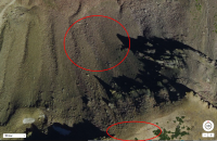
There certainly does appear to be remnants of an old faint path up the "Priord Pass" between Priord Lake and the saddle east of Yard Peak (shadow in bottom left). You can see a bit of path right on the saddle in the image below and few more switchbacks through the scree to the north. @Parma, @Blake Merrell, @Jackson, and I are planning on looping Allsop with Priord this July (if we aren't thwarted by snow as well), and may try to head up and explore that old path from Priord if conditions and time allows us while we're there.

Screenshot 2017-03-10_10-24-23.png

As for Dead Horse...yeah, what's already been said is good food for thought. This year looks to be equal and maybe even a little more than 2011 snow pack levels which as we all know, is when Eric Robinson was apparently thwarted by too much snow on that pass about the same time of year, sending him on a detour that unfortunately proved equally as dangerous for him. Certainly worth it to delay until around late August if you can make that work.
 
There certainly does appear to be remnants of an old faint path up the "Priord Pass" between Priord Lake and the saddle east of Yard Peak (shadow in bottom left).

It's also easily visible from the ground at Priord Lake.

This year looks to be equal and maybe even a little more than 2011 snow pack levels

I'm not sure if the two years are a good comparison, even if the snowpack numbers might match up in some ways right now. 2011 was incredibly unique in that most of the snow came in the late spring. As of now, most of our snow has come in the winter and it may melt off much in the same pattern as a normal year (but with more of it).
 
It's also easily visible from the ground at Priord Lake.

I'm not sure if the two years are a good comparison, even if the snowpack numbers might match up in some ways right now. 2011 was incredibly unique in that most of the snow came in the late spring. As of now, most of our snow has come in the winter and it may melt off much in the same pattern as a normal year (but with more of it).

Great point @Nick! Time will tell.
 
We definitely would prefer a later date it doesn't appear that's going to work with everyone's work schedules.


Sent from my iPhone using Tapatalk
 
It seems odd to me that caltopo shows the trail over that pass where no one else done.


Sent from my iPhone using Tapatalk
 
I think the plan for @NateGeesaman was to drop over to Allsop, and complete a loop back to his car (he was solo), hence the carrying of at least 8 beers I believe! Along the ridge line over to Allsop it became too much, so he turned around and went back the way he came. He got some great shots though, maybe he'll share.
 
I swear I read a trip report on here a few years ago of someone going from Priord Lake over into Rock Creek via "Priord Pass". I'm pretty sure it's doable.
 
Well now this is interesting. Not sure it's much of another option for skirting Dead Horse Pass but...

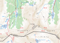
If on caltopo you choose the FS Topo 2016 as your base map and add the MapBuilder Overlay there is another route from Allsop Lake over to the EFBR. Would still have to go all the way out WFBF and drop back south to Allsop but...

upload_2017-3-11_16-16-40.png
 
Well now this is interesting. Not sure it's much of another option for skirting Dead Horse Pass but...

If on caltopo you choose the FS Topo 2016 as your base map and add the MapBuilder Overlay there is another route from Allsop Lake over to the EFBR. Would still have to go all the way out WFBF and drop back south to Allsop but...

View attachment 53089

As I think about it I'm betting that pass would be as likely as Dead Horse to have lingering snow as well. But interesting option to connect those two basins.
 
Well now this is interesting. Not sure it's much of another option for skirting Dead Horse Pass but...

If on caltopo you choose the FS Topo 2016 as your base map and add the MapBuilder Overlay there is another route from Allsop Lake over to the EFBR. Would still have to go all the way out WFBF and drop back south to Allsop but...

View attachment 53089
This route is on a map? Interesting. I think @Dan may have walked this....
 
Similar threads
Thread starter Title Forum Replies Date
J Uinta Highline Trail Shuttle Trip Planning 0
Parma Uinta Highline Trail Website General Discussion 1
Born to Hike 85 miles on the Uinta Highline Trail including Crater Lake and a Dinosaur: July 26 - Aug 1, 2020 Backpacking 35
S Uinta Highline Trail shuttle options? Trip Planning 5
Born to Hike Early June 3-day jaunt on the Uinta Highline Trail: Naturalist Basin, Pinto Lake, Margo Lake Backpacking 8
sydissoocool Looking for a backpacking buddy for Uinta Highline Trail Noobs: Introduce yourself! 6
Parma Highline: A feature documentary on the Uinta Highline Trail General Discussion 21
DuneElliot Trip Report: Backpacking the Uinta Highline Trail, July 2018 Backpacking 6
K Uinta Highline Trail, July 4-8 2018 Backpacking 6
Perry Uinta Highline trail - East to West - Mission Accomplished! Backpacking 24
Amanda Mitchell Vernal, Utah Uinta Highline Trail shuttle offer Noobs: Introduce yourself! 9
Perry Uinta Highline Trail - East to West Backpacking 21
Perry Uinta Highline Trail: Food and Bears. General Discussion 39
Blake Merrell Planning a Uinta Highline Trail Trip Trip Planning 51
DaveW Uinta Highline - Chepeta Lake to Hayden Pass Backpacking 6
M Backpacking 50 miles in the Uinta Mountains for 5 days with ~50 pound pack Backpacking 4
regehr uinta snow? Trip Planning 6
R Eastern Uinta Solo Trip Advice Request Trip Planning 5
Perry In Search of a Prime Uinta Vista Trip Reports 8
Dave High Uinta sheep grazing EIS General Discussion 2
Stickerbumper Uinta Discovery Trail 2018 Backpacking 17
jdfut66 Uinta Loop suggestion Trip Planning 3
jar155 Murdock Basin, Uinta Mountains 7.28.2018 Hiking & Camping 2
uintafly Kid Uinta backpacking trip Trip Planning 7
jar155 North Erickson Lake, Uinta Mountains (off trail approach) Backpacking 9
jdfut66 Uinta trip - Priord to Dead horse Loop Trip Planning 9
Nick 19 Highest Uinta Peaks in 33 Hours General Discussion 13
Luke High elevation uinta campgrounds/lakes General Discussion 9
Perry Suggestions for 3-day/2-night Uinta's Route Trip Planning 10
westy Uinta waterfalls Trip Planning 5
jtarheel1 Uinta Trip in Mid October? Trip Planning 34
andyjaggy Missing Uinta Man Found General Discussion 0
Devin Ashby Ostler Peak - Amethyst Basin - High Uinta Wilderness Backpacking 0
Devin Ashby Packard Lake - Uinta Mountains Backpacking 6
ogg Bear precautions at Uinta trailheads? Trip Planning 5
Utsbeme North Erickson Lake, Uinta Mountains Backpacking 7
Blake Merrell 50 miles of High Uinta Majesty! - A dream come true. Backpacking 24
weston Uinta car camping- few spots picked out, help needed! Trip Planning 0
Ralph Perry I am a long-time backpacker needing UINTA suggestions Noobs: Introduce yourself! 1
gloo Uinta's in late sept Trip Planning 3
Nick Invite Backcountrypost Uinta Fest 2012! Meet Up (Members Only) 75
uintafly 3 days in the Uinta's, looking for somewhere new Trip Planning 2
Yellowstone 1 Uinta's 6/15-6/17 Fairy Forest Hiking & Camping 1
gloo Uinta Conditions? Trip Planning 2
leatherman Uinta backpacking recommendations Trip Planning 4
JBG Water Beta 2022 - Highline Trail Trip Planning 6
JBG Water on the Highline Trail - 2021 Trip Planning 2
LarryBoy Looping the Highline: Gilbert Peak Edition Backpacking 13
Perry Looping the Highline - Episode Three: The Crossing Backpacking 6
DrNed Highline Movie General Discussion 6

Similar threads

Back
Top