Navigation
Install the app
How to install the app on iOS
Follow along with the video below to see how to install our site as a web app on your home screen.
Note: This feature may not be available in some browsers.
More options
Style variation
You are using an out of date browser. It may not display this or other websites correctly.
You should upgrade or use an alternative browser.
You should upgrade or use an alternative browser.
Uinta Highline Trail Part II Planning
- Thread starter Perry
- Start date
- Joined
- Aug 8, 2016
- Messages
- 2,079
That trail must be the one these guys found.... http://www.bogley.com/forum/showthr...12-14-2011&s=90929e6872c900a53dcdae78a5721306
- Joined
- Jun 25, 2012
- Messages
- 4,433
Thanks, pretty great photography in that report too! Which is explained because it IS our very own @Dan before this site came alive. He is a phenomenal photographer....That trail must be the one these guys found.... http://www.bogley.com/forum/showthr...12-14-2011&s=90929e6872c900a53dcdae78a5721306
- Joined
- Aug 8, 2016
- Messages
- 2,079
Thanks, pretty great photography in that report too! Which is explained because it IS our very own @Dan before this site came alive. He is a phenomenal photographer....
I was wondering when I saw the name
")
Sent from my iPhone using Tapatalk
- Joined
- Aug 8, 2016
- Messages
- 2,079
@Jen walked that route between allsop and priord last year and posted a TR here. There isn't much of a trail anymore but people do it fairly often.
I just read that post. Sadly all the picture links are now broken
 I would liked to have seen some of them for perspective.
- Joined
- Jun 25, 2012
- Messages
- 4,433
It looks like that new trail is on the Forest Service map used in the Caltopo layer FSTopo (2016). These two layers (2013 and 2016) are new to me. I have used the USFS Visitor layer before to great effect but it does'nt not cover this section of the Uintas. Great find and thanks for sharing. I am not sure what the impact or use of the MapBuilder Overlay piece in your instructions is though. What is MapBuilder Overlay for in your view and note that you can see the trail without this overlay.Well now this is interesting. Not sure it's much of another option for skirting Dead Horse Pass but...
If on caltopo you choose the FS Topo 2016 as your base map and add the MapBuilder Overlay there is another route from Allsop Lake over to the EFBR. Would still have to go all the way out WFBF and drop back south to Allsop but...
View attachment 53089

- Joined
- Jan 4, 2015
- Messages
- 2,908
Caltopo auto-routing trails has plenty of trails that aren't trails - for example, there are two "trails" listed going over Jackass Pass in the Winds - and the one around the west side of the little lake definitely doesn't exist. I don't know exactly how or why caltopo thinks these trails exist, but gotta be careful with that.
- Joined
- Aug 9, 2007
- Messages
- 12,967
Caltopo auto-routing trails has plenty of trails that aren't trails - for example, there are two "trails" listed going over Jackass Pass in the Winds - and the one around the west side of the little lake definitely doesn't exist. I don't know exactly how or why caltopo thinks these trails exist, but gotta be careful with that.
There are two trails over Jackass. I have done the one on the west side of Arrowhead Lake (Report here). There is a section of picking through the rocks, but it's definitely a well-travelled trail.
- Joined
- Jan 4, 2015
- Messages
- 2,908
You're a better route finder than I am then! The trail up until the lake is pretty clear, but after that, I was full-on scrambling. I did do it in snow though so maybe it's more clear when it's clear. Nice photo by the way!There are two trails over Jackass. I have done the one on the west side of Arrowhead Lake (Report here). There is a section of picking through the rocks, but it's definitely a well-travelled trail.

- Joined
- Aug 8, 2016
- Messages
- 2,079
It looks like that new trail is on the Forest Service map used in the Caltopo layer FSTopo (2016). These two layers (2013 and 2016) are new to me. I have used the USFS Visitor layer before to great effect but it does'nt not cover this section of the Uintas. Great find and thanks for sharing. I am not sure what the impact or use of the MapBuilder Overlay piece in your instructions is though. What is MapBuilder Overlay for in your view and note that you can see the trail without this overlay.
View attachment 53144
I'm not exctly sure what all the MapBuilder overlay does except it makes solid red lines in stead of the more traditional dashed trail lines. It also adds trails that are not on the base map. This is how I ran across the trail over from Priord to Rock Creek basin. Try turning it off and that trail disappears. I'm wondering if these "additional" trails are not GPS tracks from folks who have traveled those routes. I tried googling a bit about the MapBuilder overlay and there are discussions about a possible subscription-based model that lets you create custom maps. Details are scarce so far in my research. The trail over from Allsop to Priord comes from the FSTopo 2016 base map.
- Joined
- Aug 8, 2016
- Messages
- 2,079
I found some more detail on MapBuilder... http://caltopo.blogspot.com/search/label/map layers Look for the section entitled "MapBuilder: Pimp Your Topo"
- Joined
- Jul 23, 2013
- Messages
- 1,666
I'm not exctly sure what all the MapBuilder overlay does except it makes solid red lines in stead of the more traditional dashed trail lines. It also adds trails that are not on the base map. This is how I ran across the trail over from Priord to Rock Creek basin. Try turning it off and that trail disappears. I'm wondering if these "additional" trails are not GPS tracks from folks who have traveled those routes. I tried googling a bit about the MapBuilder overlay and there are discussions about a possible subscription-based model that lets you create custom maps. Details are scarce so far in my research. The trail over from Allsop to Priord comes from the FSTopo 2016 base map.
I think the source of some of these "trails" on the MapBuilder layer are sourced from Open Streetmap project (OSM) where contributors upload their GPS tracks to the public open source project. So, these "trails" from Rock Creek to Priord, and from Priord to Allsop, are probably there because somebody tracked their GPS as they navigated those routes, and should not be taken to be a well trodden and maintained path. But hey, the fact that somebody else has successfully navigated those routes in those spots should give you a boost of confidence that it is doable.
- Joined
- Aug 8, 2016
- Messages
- 2,079
I think the source of some of these "trails" on the MapBuilder layer are sourced from Open Streetmap project (OSM) where contributors upload their GPS tracks to the public open source project. So, these "trails" from Rock Creek to Priord, and from Priord to Allsop, are probably there because somebody tracked their GPS as they navigated those routes, and should not be taken to be a well trodden and maintained path. But hey, the fact that somebody else has successfully navigated those routes in those spots should give you a boost of confidence that it is doable.
The trail from Allsop to Priord shows up on the FSTopo 2016 base map so combined with @Dan having done that route gives credence to somewhat of a legitimate trail there. The one from Priord to Rock Creek Basin, not so much but probably doable.
- Joined
- Aug 9, 2007
- Messages
- 12,967
credence to somewhat of a legitimate trail there.
There is not a trail there. There are faint remnants of an old sheep trail. It's doable, just don't think of it as a trail to be followed. Check out Jen's recent report.
- Joined
- Aug 8, 2016
- Messages
- 2,079
I'm day hiking West Fork Blacks Fork tomorrow up to Deadhorse Lake, and perhaps the pass if the snow looks okay and I enough gas in the tank. I'll let you know how the pass looks from the north side (which is where would be terrible).
Looking forward to current intel!
Sent from my iPhone using Tapatalk
ridings82
Member
- Joined
- Feb 2, 2017
- Messages
- 42
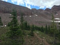
I took this picture of Dead Horse Pass yesterday a few feet above the lake as I lost the tree line. I hiked about halfway up the pass; it was a 21-mile day hike so the entire thing wasn't in the deck of cards. I crossed one small snowfield that was low in difficulty and danger. I did the Highline last year and know exactly what that trail is like. If I'm in your shoes, I probably wouldn't be carrying any extra gear to get over the pass. At best, microspikes only, to feel more comfortable. I suppose there could be some snow at the tippy top but that's about it. I could also see Red Knob Pass from the trail and that was clear of snow.