Survivorman in Utah

Oh, and I'm not sure that he actually couldn't find a way down into Swett Creek. That shouldn't have been so hard with a little searching.

I agree with this, too. I mean, if anything, he could have walked half a mile back to the road and dropped down into Swett or Woodruff at the normal trailheads!

You nailed it. The helicopter ride was definitely just for some fancy footage and nothing to do with his hike. Definitely on the north side of Holmes by Swett Creek the first two nights and definitely the south side afterward. Definitely would have needed a lift to get down there and it appears it was still quite early in the day. Very disappointing, Mr. Stroud. :(

Woo hoo! I'm glad you agree with me! And, yeah, I was disappointed that there was so much moving and editing. I didn't think he did things like that.

Snow all around his first campsite but has to leave for lack of water?

Good point. Why would he move, then? It's just weird.

There is no canyon with a 1500 foot descent out there! Looks closer to 500 feet to me.

Yeah, looking at the topo, you're right...it's right about 500 feet. Maybe he did it twice to retrieve his camera...

Now with that said, I'd like to go find both of his campsites. When are we going?

My calendar says that I'm going to Halls Creek this weekend, and then Cooke City next weekend, and then back to Ticaboo on February 1st to look for those campsites! You in? :)
 
You doing the HC Narrows in January? Frosty!

I wasn't planning on going through any water. I've just somehow never been there at all, so I wanted to go check it out. But if the weather is as cold this coming weekend as it was this past weekend, I may chicken out. Especially since we're driving all the way up to Cooke City the next weekend...that's a long drive.

Let's do it!

Let's do the 1st. It'd be fun! Between us, I think we could find both campsites.
 
My .02 - save it for when it's warmer. Quite a bit of mandatory wading and quite possibly swimming in there. It would be kind of a shame to hike all the way in there and not see all the goods. And if you're trying to avoid crowds, we did it in April and didn't see another soul in 3 days.

I've got that weekend of the 1st blocked out for it.

Back on the Survivorman & David Holladay thing. I thought this was interesting after watching the episode...

 
Holy smokes Keith! You are determined. You could be an investigator. No, wait..... :thumbsup: I may have to go rent the episode to see what all the hoopla is about even though I can't stand the guy.
 
Good geo-sleuthing you guys.

I knew a lot of his stuff was dramatized -- but I didn't realize that much.

At least he didn't walk down a canyon and come to a dead end WALL where he had to climb out a la Bear Grylls. Or drink his own urine.

- Jamal
 
I am quite sure I have located the spot where he spent the first two nights north of Holmes and it is even more depressing than we had suspected. I might even have figured out the exact tree, but at the very least, it's within a hundred yards or so of here: 37.83638,-110.580217

This means that Les spent the first two nights of this episode less than 300 yards from a paved highway.

Here's my evidence:

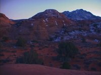
Les took quite a few shots of his camp from some rocks behind the tree he was using for shelter. The big tree in the image below is where he was sleeping. Notice the prominent sandstone dome in the center of the photo, the north side of Holmes in the background, and if you look carefully, there is actually a drainage between him and the snowy canyon wall just across from him. At first it looks like it is just a valley, but I think that is definitely a canyon down there.

sunsetview.jpg

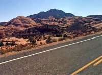
Now look at this Google street view image taken from Highway 276 at about 37.839055,-110.581151. Look familiar?

lescamp-zoom.jpg

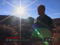
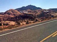
The other big indicator was a distinctive flat ridge with a little cone to the right that was visible from his camp during sunset each day. Here:

les-ridge1.jpg

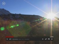
Notice the foot of Holmes in the left on this one.
les-ridge2.jpg

Now if you go back to that street view shot, you can actually see the flat ridge and the cone from the highway! And if you look on the map near his campsite, the cone and ridge are clearly visible across the drainage: 37.835035,-110.583278

streetview-labeled.jpg
 
I created a map of the spots we've nailed down so far. Keith - do you have a google account? I just have your website email. I can add you as a collaborator.

[parsehtml]
<iframe src="https://mapsengine.google.com/map/embed?mid=zO3RqOwYLlrM.klv-sLi4TIe0" width="850" height="600"></iframe>
[/parsehtml]
 
Outstanding work!

I'll digest it when I get home, but on my little screen it looks like you and I are within about 50 yards of each other on our guesses. Is that right?

Now we need to go find those campsites.

And try not to be too depressed by our findings...
 
At one point he said that his crew was camping several miles from him. Well, the Ticaboo Lodge was only a few miles from him at both locations...
 
Ha! Yes, I didn't realize that. You guessed directly across the drainage from where I think he was. :)
That's even better that you didn't realize that, because it probably means we're awfully close.
 
At one point he said that his crew was camping several miles from him. Well, the Ticaboo Lodge was only a few miles from him at both locations...


I hope they didn't have to spend too much on helicopter fuel to fly in and clean up his first camp. :) How funny would it be if we go there and it's all still in tact? I say you scrap Halls Creek and we go this weekend!
 
Back
Top