Navigation
Install the app
How to install the app on iOS
Follow along with the video below to see how to install our site as a web app on your home screen.
Note: This feature may not be available in some browsers.
More options
Style variation
You are using an out of date browser. It may not display this or other websites correctly.
You should upgrade or use an alternative browser.
You should upgrade or use an alternative browser.
Guess the spot: Utah Edition
- Thread starter Ben
- Start date
- Joined
- Jun 11, 2017
- Messages
- 4,612
Why not? 
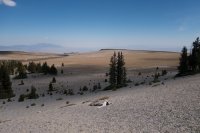
And that feature in the foreground looks like a dead bristlecone pine to me, if a pine can be a feature.
And that feature in the foreground looks like a dead bristlecone pine to me, if a pine can be a feature.
Last edited:
- Joined
- Jun 11, 2017
- Messages
- 4,612
I think I know where this is. You're at the Table, north of Mt. Moriah, looking at Utah's Deep Creek Mtns. in the distance.
Udink
Still right here.
- Joined
- Jan 17, 2012
- Messages
- 1,742
D'oh! I should have gotten that, since @regehr just last month told me about his hike there. But I kept thinking it looked like something along the northern border.I think I know where this is. You're at the Table, north of Mt. Moriah, looking at Utah's Deep Creek Mtns. in the distance.
- Joined
- Jun 11, 2017
- Messages
- 4,612
- Joined
- Jun 11, 2017
- Messages
- 4,612
SteveR
Member
- Joined
- Sep 22, 2016
- Messages
- 1,030
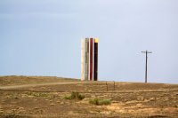
My first thought was- If we were looking for an Alberta location, it would probably be yet another of the many examples in Calgary of taxpayer fleecing in the name of public "art". Googling Green River and looking at images confirmed my cynicism- it is in fact art.
- Joined
- Jun 11, 2017
- Messages
- 4,612
There's an interesting story behind this. The fellow who owns this hill that this art sets on commissioned a famous artist to do this. This is the second one there that he's commissioned. The irony is, the art patron is blind.
http://archive.sltrib.com/article.php?id=51832250&itype=cmsid
http://archive.sltrib.com/article.php?id=51832250&itype=cmsid
Last edited:
Don't like ads? Become a BCP Supporting Member and kiss them all goodbye. Click here for more info.


