Navigation
Install the app
How to install the app on iOS
Follow along with the video below to see how to install our site as a web app on your home screen.
Note: This feature may not be available in some browsers.
More options
Style variation
You are using an out of date browser. It may not display this or other websites correctly.
You should upgrade or use an alternative browser.
You should upgrade or use an alternative browser.
Guess the spot: Maps Edition
- Thread starter Backcountry Post
- Start date
- Joined
- Jan 4, 2015
- Messages
- 2,904
the brain inside your head can't figure it out?I'm having a brain cramp trying to recall a road with cul de sac at 11,278 in Utah....
- Joined
- Jun 25, 2012
- Messages
- 4,430
the brain inside your head can't figure it out?
No, it is all cramped up.
OK, so now you have thrown down the gauntlet....
Last edited:
- Joined
- Jun 25, 2012
- Messages
- 4,430
OK, it is Brian Head Peak.
Now, this is what I like about this game. Once you start doing some research you discover, serendipitously, a bunch of other destinations to explore. Cool. Look what I found - a bunch of new places to explore. The highest paved and dirt roads in Utah and Colorado, albeit a partial listing. I haven't been to some of them.
https://www.deseretnews.com/article/660205171/Enjoy-Utahs-scenic-heights-from-your-car.html
- Joined
- Jun 11, 2017
- Messages
- 4,612
Great clue, @LarryBoythe brain inside your head can't figure it out?
The new one's the drainage off Fremont Peak!
Last edited:
- Joined
- Jun 25, 2012
- Messages
- 4,430
Fremont Peak in the Windies? No, this is a desert place.
- Joined
- Jun 11, 2017
- Messages
- 4,612
Art, every place ultimately connects to Fremont Peak, you know that.Fremont Peak in the Windies? No, this is a desert place.
- Joined
- Jun 25, 2012
- Messages
- 4,430
I am not sure I grok you but here is a smiley face anywayArt, every place ultimately connects to Fremont Peak, you know that.
- Joined
- Jun 11, 2017
- Messages
- 4,612
As long as you smile, no need to understand. I was referring to Jeffry Chandler always guessing Fremont Peak in some old Guess the Spot threads.I am not sure I grok you but here is a smiley face anyway
- Joined
- Jun 11, 2017
- Messages
- 4,612
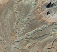
Is this out by Factory Butte?
- Joined
- Jun 11, 2017
- Messages
- 4,612
I would guess entrenched meanders.
- Joined
- Jun 25, 2012
- Messages
- 4,430
It is not. But I could see it being in that badlands.Is this out by Factory Butte?
- Joined
- Jun 25, 2012
- Messages
- 4,430
I believe it is the nature of that topography and an indication of the huge variability of topography on our planet and all of the thousands of other planets.Why are there so many forks?
Short answer: I have no effing idea.... But it makes me plan to go there. :twothumbs:
- Joined
- Jun 11, 2017
- Messages
- 4,612
- Joined
- Jun 25, 2012
- Messages
- 4,430
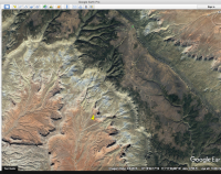
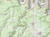
That's it. And our fearless leader may be out there right now! Luck, @Nick !View attachment 59386 Not sure what to call this, but is under 50 Mile Mountain (Straight Cliffs) - maybe it's Rock Creek, but drains into Powell. Here's a screenshot - Google Earth doesn't name it.
https://backcountrypost.com/threads/grand-bench-road.7163/
- Joined
- Jun 11, 2017
- Messages
- 4,612
Don't like ads? Become a BCP Supporting Member and kiss them all goodbye. Click here for more info.


