Navigation
Install the app
How to install the app on iOS
Follow along with the video below to see how to install our site as a web app on your home screen.
Note: This feature may not be available in some browsers.
More options
Style variation
You are using an out of date browser. It may not display this or other websites correctly.
You should upgrade or use an alternative browser.
You should upgrade or use an alternative browser.
Guess the spot: Maps Edition
- Thread starter Backcountry Post
- Start date
- Joined
- Jun 25, 2012
- Messages
- 4,430
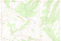
That is a problem. But I'll bet there is a low guess rate because everyone is out !you guys need to get out more.
View attachment 58459
Ben
Member
- Joined
- Sep 12, 2014
- Messages
- 1,873
: ) you're up.Yeah, I've been out for weeks, but I'm finally back.
That's Old Snowy Mountain, in the Goat Rocks country of south-central Washington.
Kishenehn
Member
- Joined
- Dec 13, 2016
- Messages
- 138
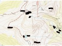
OK, hopefully this will wrap this one up:
If you take the main road that heads west off the map, and make the correct choices at a couple of two-track junctions, and aren't shot as a trespasser, in a few miles you'll be one of the relatively few people who's achieved the summit of the highest mountain in a particular unit of the NPS system.
If you take the main road that heads west off the map, and make the correct choices at a couple of two-track junctions, and aren't shot as a trespasser, in a few miles you'll be one of the relatively few people who's achieved the summit of the highest mountain in a particular unit of the NPS system.
mike_offerman
Member
- Joined
- Feb 8, 2012
- Messages
- 566
Ahh! Mt Zenobia, highest point in Dinosaur. Have not been there, but have been looking at it!
Kishenehn
Member
- Joined
- Dec 13, 2016
- Messages
- 138
That’s it! The map focuses on the old coke ovens below Douglas Mountain, which are a cool destination in their own right.
I haven’t been to Zenobia in many years, but it’s high on my bucket list for next summer. Apparently, nowadays there are No Trespassing signs on the road to the monument boundary, and a padlock on the Park Service gate.
You’re up!
I haven’t been to Zenobia in many years, but it’s high on my bucket list for next summer. Apparently, nowadays there are No Trespassing signs on the road to the monument boundary, and a padlock on the Park Service gate.
You’re up!
mike_offerman
Member
- Joined
- Feb 8, 2012
- Messages
- 566
- Joined
- Jun 25, 2012
- Messages
- 4,430
Kish... can you clarify please? there are NO no trespassing signs on the road and NO padlocks? Thus, legal and do-able? Thanks.That’s it! The map focuses on the old coke ovens below Douglas Mountain, which are a cool destination in their own right.
I haven’t been to Zenobia in many years, but it’s high on my bucket list for next summer. Apparently, nowadays there are No Trespassing signs on the road to the monument boundary, and a padlock on the Park Service gate.
You’re up!
- Joined
- Jun 25, 2012
- Messages
- 4,430
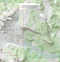
That is a high, high road. I am guessing in the San Juan's ?
mike_offerman
Member
- Joined
- Feb 8, 2012
- Messages
- 566
Not the San Juan's, but the right state.
Kishenehn
Member
- Joined
- Dec 13, 2016
- Messages
- 138
It's been a long time since I've been all the way up there myself, so a good chunk of this is second hand.Kish... can you clarify please? there are NO no trespassing signs on the road and NO padlocks? Thus, legal and do-able? Thanks.
There's a decent 2-track road all the way to the top of Zenobia. (The Park Service has a fire lookout up there.) Until a decade or so ago it was a pretty straightforward trip -- the only issue was that the 2-tracks aren't signed, and you had to figure out which is the right one. The primary route crosses private property, though, and I've heard that a few years ago the landowner began posting his land. About the same time, the Park Service padlocked the gate at the monument boundary, since the Zenobia area is being managed for wilderness values. (The lookout staffer still drives the road, though.) That gate is just a couple miles or less from the top.
So it's likely that today, one would need to work out a route around the posted property and then hike up to Zenobia. I'm told it's doable, though, and I'd like to figure that out next summer.
- Joined
- Jun 25, 2012
- Messages
- 4,430
@LarryBoy, how's about a hint?
- Joined
- Jan 4, 2015
- Messages
- 2,904
oh wow, apparently it DID take very long! It's in Utah, and notice the road in the bottom part of the frame.@LarryBoy, how's about a hint?
Don't like ads? Become a BCP Supporting Member and kiss them all goodbye. Click here for more info.


