Unfinished Business: Highline 2018

When we went through Lambert Meadows wasn't like that at all. Can you give me some coords of where it was really bad for you to make sure I'm thinking straight?
This graphic I had already made for the sheriff during the rescue. The region I labeled the navigation crux is where I encountered the place that would be the most difficult to navigate on the whole highline trail. When I say this I am referring to the west end, west of King's peak, because at that time in the rescue we knew the missing Australian had made it at least to King's peak, actually he had been seen around Cleveland pass. When I say it was the crux I don't mean for me, I mean for someone that a)wasn't from around here b)was possibly inexperienced in the alpine and c)was possibly inexperienced with GPS navigation likely not having downloaded GPS maps or the trail as a track. (The Leidy peak end, the east end, is a bit of a challenge navigation-wise as well but I find that stimulating and we knew he was well past that.)

In this section, labled the navigation crux, the trail was basically obliterated by lack of maintenance and countless sheep trails and no real vegetation due to their overgrazing. In this region you don't want to be making your way straight down the drainage as you normally do and are inclined to do. Instead, the trail, if it was there and the "route" when it wasn't, was to stay high and to the north of the actual Oweep stream drainage intending to contour up high and through the Lambert Meadows. In actuality this was pretty easy to dead reckon in good weather because you could aim for the foot of that prominent north/south ridge just east of Lambert Meadows proper. But you would have to know the trail headed that way. Once I walked down out of the alpine tundra of the upper Oweep we had to start contouring through the krummholz trees and brush and then finally forest aiming for the toe of that ridge. Only occasionally did we find the Highline itself. It came and went, especially with boulder fields and yet more grazing. We had no GPS track to follow but instead had a waypoint every quarter mile that I had hand entered in the GPS using the trail on a topo map ahead of time.

Once I finished and came back in to help with the search at the impromptu heliport this is the area where I coached the SAR team to cover again and was ultimately successful in getting them to fly me back in to it in order to spend another couple of days searching, to no avail. Ultimately the gentleman's body was found further west and well off the Highline and west of Dead Horse Lake. I think there is even a thread here about the incident.
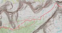
1544415645046.png
 
I agree that the eastern end of your rectangle was replete with sheep trails. Cairns were pretty easy for us to follow but some of the trails around Oweep would just fade into nothing, while another would begin 30 feet away.
 
I can also see that, if you were travelling eastbound, the going down from Red Knob Pass into Lake/Oweep forks could be tough. Westbound it's not too bad, since you kinda just head towards the pass once the trail disappears, but it would be a little tougher going EB.
 
Maybe @WasatchWill can remember better than me, but I remember losing the trail around that area right around a stream crossing. We didn't lose it for too long, because we of course never get lost, but it was in that area you have marked.
 
Maybe @WasatchWill can remember better than me, but I remember losing the trail around that area right around a stream crossing. We didn't lose it for too long, because we of course never get lost, but it was in that area you have marked.
I seem to remember several points all along that trail where it seemed to fade away for a bit. All through Oweep and up to Red Knob was definitely notorious for that it seemed. The sign for that junction with the Highline on the east bench of Rock Creek is definitely easy to miss and is a bit confusing with how its arrows point.

- Response from my phone -
 
Thanks! We each had Gaia running on our phones and a custom printed set of USGS 7.5 quads. We also had a GPX track of the route recorded by @Artemus to look at as needed. We also had one overview paper map of the Uintas (Trails Illustrated) amongst the group. We didn't use the paper maps much but they're important to have. The crux of navigation for us was in the Oweep drainage. The trail there is mostly nonexistent in many places but it didn't really matter much. We just walked over the grass and kept on track to where we wanted to be. In Rock Creek, we were moving so fast that last morning that we went right past our junction and ended up hiking cross country for quite some time to rejoin the proper Highline with minimal backtracking.


I have never heard of Gaia. I will have to check it out. Where online would someone go to find a recorded GPX track of the route?
 
I have never heard of Gaia. I will have to check it out. Where online would someone go to find a recorded GPX track of the route?

Gaia is awesome. A lot of the people here use that on their phones as their primary GPS device. You can cache maps for offline use and they have a lot of different map layers available. I'm a big fan.
 
I have never heard of Gaia. I will have to check it out. Where online would someone go to find a recorded GPX track of the route?
You can find whole threads and multiple references to backcountry GPS programs for phones, dedicated GPS devices, and GaiaGPS here at BCP.
 
I am considering doing the Highline Trail this year beginning at Hwy 191. I am debating between going in early July and early September. I am trying to weight the pros and the cons of each time frame and wondered if you had any thoughts. It looks like you hiked it in July. If you did it again was July a good month. Some of the pros and cons I have thought of so far.
July - Pros (the 4th holiday means less vacation and there is more water in July) Cons (More mosquitoes and snow in the passes to contend with).
 
Dead Horse Pass likely will not be safe to cross in early July this year. In a really bad snow year like last year, it was still pretty sketchy and may not have been doable just days earlier. We crossed it on July 8th. For a good snow year (like we're having now), I think you pretty much have to shoot for August, and even then it may still have significant snow.
 
I am considering doing the Highline Trail this year beginning at Hwy 191. I am debating between going in early July and early September. I am trying to weight the pros and the cons of each time frame and wondered if you had any thoughts. It looks like you hiked it in July. If you did it again was July a good month. Some of the pros and cons I have thought of so far.
July - Pros (the 4th holiday means less vacation and there is more water in July) Cons (More mosquitoes and snow in the passes to contend with).

September is probably more reliably dry and with high pressure too.
 
I’ve done the Highline in two sections. In 2016 highway 191 exiting at Henry’s fork then in 2017 from the Uinta River trailhead exiting at Hayden Pass. Both done the last week of August into September. Monsoonal storms were not a problem but both trips had weather systems come through for a couple of days. I consider them bad luck for that time of year. YMMV. Bonus for late in the year... No bugs! Not lush green that time of year but a beautiful golden brown nevertheless. Another consideration late in the year is fewer daylight hours to hike.

I might be planning another trip this year and would likely do it late again.


Sent from my iPhone using Tapatalk
 
Congrats!

Completed the Highline myself the first week of August 2017. Started at Leidy on Friday afternoon and hiked out by Thursday afternoon.

I've backpacked many places, but the Highline tops the list.

Day 1: Leidy to Whiterocks lake. Rainstorms most the way, which was depressing. Nevertheless the scenery is awesome because it's so different. Navigation was fun and this was a section i really looked forward to. Only warning for others, is that west of Leidy is ankle snapping rocky. Softens up soon after though.
Day 2: Whiterocks to meadows below middle Reader lake. DWR was rotenoning the lake for reintroducing Cutthroat. Can't wait to get back up there and fish. All in all, this is a boring stretch and the trucks at Chepeta pull you out of that 'wilderness' feel. No energy to push up North Pole so we enjoyed a shorter day.
Day 3: Reader lakes to Kidney lakes. Wow, North Pole pass is big. Views of the 13'ers is epic. Kidney Lakes feels so remote, but at least three other groups there. Enjoyed a campfire that night, only time during the whole trip.
Day 4: Kidney Lakes to Upper Painters. Just west of Kidney is the only place we lost the trail in the deep timber. Painters Basin is awesome, surprised you didn't enjoy it. Rain stopped us from getting over Anderson. No worries, views were fantastic, but it rained a lot after we setup camp in between the shrubby bushes. Evening light coming over Kings was beautiful.
Day 5: Painter to North Star lake. My third time on Anderson. Felt easier than North Pole. Rained through Yellowstone. Camping by North Star was very exposed. Quintessential Uintas in my opinion, upper Garfield is other worldly.
Day 6: North Star to Dead Horse. Starting to feel the pull of home. Long day, obviously. View of Oweep from Porcupine at Sunrise is the best in the entire range. Unbelievable glacial topography. Ate breakfast in Upper Oweep. Kept seeing white tufts of cotton, then realized we practically sat down on top of a dead sheep. Passed several groups doing the Highline from West to East. Didn't have any trouble following trail through Oweep and Lambert. Wanted to pull out my tenkara rid on Lake Creek, but no time, gotta keep moving. Got caught in a scary thunderstorm at the base of Red Knob. Hunkered down inside the shrubby bushes. Shouldn't take that risk again. View from Red Knob of Beulah ridge after rainstorm is transcendental. So tired after rolling into Dead Horse. Many groups camping there, too many dead trees. Epic, end of world thunderstorm that night.
Day 7: Dead Horse to Trailhead. Beautiful sunrise from Dead Horse pass. Chose the direct line down to Rock Creek and back up. Would have rather skirted the upper basin. Dozens of people from Rocky Sea to trailhead. Every tree is dead, really don't like the Mirror Lake scene anymore. Hey, we did it! Holy cow, bucket list item done. Wasnt as hard as I thought it would be. Will do it again, east side rules, west side drools (but the middle is best).
 
Thanks! And nice job on your crossing.

Painters Basin is awesome, surprised you didn't enjoy it.

I liked Painter Basin a lot. I just didn't like the section between Fox and before it opens up in upper Painter. Definitely better than the Rocky Sea to Hayden section though.
 
Now that is thinking ! :) and preparing. Carrying the route on a GPS makes it safer and having paper maps and a compass as a backpack even more so. (Plus backup battery for the GPS and downloaded, local maps too as the first line of defense - from a lifelong contingency planner).

And here I thought that we've been overly cautious by downloading GPS routes on 3 phones and 1 inReach, printing out USGS maps, carrying Trails Illustrated maps, and a few backup batteries. Good to know we're not the only ones! I would add another thing or two that we do before our trips. Might not be novel, but it might help out a person or two.....We organize our trip using Google Docs and make sure the pertinent document is available offline on our phones and iPad. Further, for each website that we want to reference offline (e.g. if a website has photos of rock art, a detailed discussion of directions, etc.) we create a PDF of that site on our phone. We then copy that PDF to Readdle Documents. For each trip we create a unique folder in Readdle and file the individual PDF's under that folder. No more paper (except maps, of course)!
 
Nick,

Great trip report, photos, and videos! Thanks for being so generous with your time.

Question....Will Jen be attending the Meet-Up in April and, if yes, will she be offering dance lessons? :dance:
 

Don't like ads? Become a BCP Supporting Member and kiss them all goodbye. Click here for more info.

Back
Top