Uintas Conditions 2018

Dave

Broadcaster, formerly "ashergrey"
.
Joined
May 5, 2012
Messages
1,725
It’s never too early to start thinking of summer.

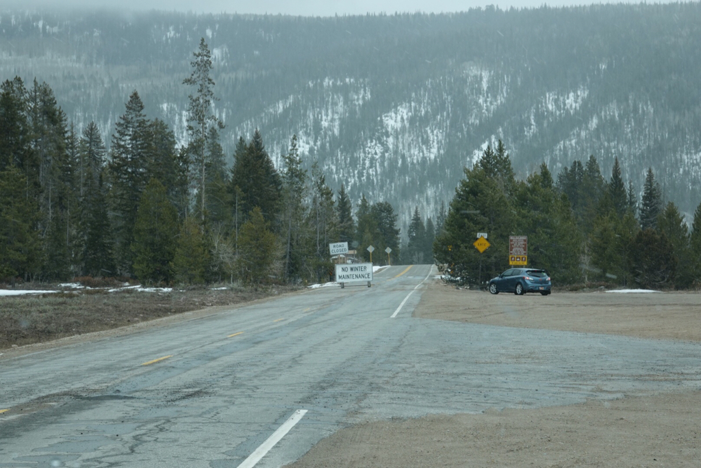
Today (2/3) I ran up to the foot of the Uintas on the north slope. At about 8500 feet, snow depth ranged from about 4-12 inches. Coverage on the higher slopes appeared decent but not amazing.

This is better than the situation in the Wasatch, but still less than ideal for water supply and fire conditions.

Unless something changes in February and March, we’re looking at an early entry to the high country this year.

927FC6B1-BE25-45D6-BFFF-682256E072CE.jpeg

F1F4583A-6F3B-4D76-A3FF-55AAC4873DEE.jpeg
 
In my limited experience, July has been my favorite Uinta month due to the flowers being in full bloom.

If things don't change, and flowers begin blooming early, will they last through the summer?

I've got a Uintas trip end of July and would hate to miss all the flowers.
 
If things don't change, and flowers begin blooming early, will they last through the summer?

June/July is pretty reliable for flowers regardless. By end of July many will have peaked, but I bet they’ll still be on in mid-to-late July. I would think the intensity and number of blooms would be affected by a low snow year more than timing, but I’m not a botanist.
 
Bittersweet. Bitter: As everyone knows, we could really use all the precipitation we can get right now. Hoping for another wetter than average spring with lots of rain down low and lots of wet heavy snow to fill up the high elevation basins. But if not, the sweet will be: Early start to alpine backpacking season.
 
Now here in Northwest Wyoming, with the warmer conditions down low, not much snow. But up in the High Country there is an above normal snowpack. Just saying.

Hope the Uintas get more snow for I hate the fires.

But I have been hiking in the wild places of the west since 1978, with also being born in Colorado. Now all because there is not a lot of snow ow, things could change as for the flowers and the summer which have seen by experience. For take 2008 for instance where I hiked in the Wyoming Absarokas that summer. The preceding winter had a huge above normal snowpack. In the following spring and summer, the flowers came up everywhere. It was really nice. But the summer became hot and dry with no moisture. The trails later in July became nothing but dry and dusty bigtime. And with no moisture, the flowers wilted. Then take 2010, where again was back in the Absaroka Wilds. The winter before hand was more dry with a below normal snowpack being in Northwestern Wyoming. But once spring came, we received gobs and gobs of moisture. We received more snow up high in the spring after the ski resorts closed, then what we had received all winter. Because of the spring moisture, the flowers came up again everywhere. During the summer there contnued to be some moisture so the flowers stayed profuse and nice. So all because there might not be much winter snowpack, there also needs to be the summer moisture also.

It looks like the whole southwest is dry this winter and pray some needed moisture inundates the entire southwest and no fires this next summer. But any spring when one can have an early access into the high country is nice in my opinion. If dry in the Uintas, then this also means that the Escalante will be good for hiking this spring with easy river crossings also with not much runoff. For whatever it is worth.
 
I'm rooting for a dryish winter as it'll allow me to get into the San Juans earlier in the season. But this might be taking it a bit too far...
 
The snow pack is low tide out there. I have not even been out splitboarding once this season. Partly due to the dangerous avalanche conditions, and lack of snow pack.

Here is the most current Snow Water Equivalent report for the west. It looks like if we do not have a bomber spring in snow fall, backpacking in the Uintas is gonna start early this year. Bitter sweet as I love the snow, but with the year we have had, I'm ready to just move on and hope for a better year next winter.

snow1802.gif
 
Was in Aspen this weekend and there was bare ground at 9k. They have basically zero base and even the groomers had grasses poking out. Got a quick foot or so on Saturday, but it's still scary dry.
 
The NWS Utah state hydrologist forecasts a 10% probability that we will get enough snow to bring us up to normal this snow season.
 
Now take a look on that map above of the snowpack, such a difference between the Uintas with the lack of snow to the Wind River Range with an above normal snowpack. And the thing is that these two places is actually not that far away from each other mileage wise. What an Interesting Winter! Hope the Uintas and the Southwest get some much needed moisture.
 
The NWS Utah state hydrologist forecasts a 10% probability that we will get enough snow to bring us up to normal this snow season.

Sorry...but I just can't resist...

giphy.gif


Now take a look on that map above of the snowpack, such a difference between the Uintas with the lack of snow to the Wind River Range with an above normal snowpack. And the thing is that these two places is actually not that far away from each other mileage wise. What an Interesting Winter! Hope the Uintas and the Southwest get some much needed moisture.

It appears all the big winter storms that usually come in from the northwest have all stayed more northward, rather then spreading southward from time to time.
 
Now take a look on that map above of the snowpack, such a difference between the Uintas with the lack of snow to the Wind River Range with an above normal snowpack. And the thing is that these two places is actually not that far away from each other mileage wise. What an Interesting Winter! Hope the Uintas and the Southwest get some much needed moisture.
Good observation Kmat. And I keep an eye on the Windies and Uintas because they are special, to me. The Winds south end was below normal until recently. And the north slope of the Uintas was normal and above for much of the season until now. I believe that dividing line between the warm colors (dry) and the cool colors (wet) is pretty much an indication of the average location of the jet stream and shows how it is pushed farther to the north again this year in its dive northwest to southeast. The firehose that used to give our Wasatch the 500" of snow at Alta that we were all accustomed to for so long had the flow with a bullseye on the great salt lake and the wasatch. Not this year.
 
If you look at Alaska on that map, its like a mini version of the lower 48's snow pack situation. Coastal and southern areas below normal, northern areas above normal.
 
I camped up near White Pine on the MLH this weekend in a dispersed camp spot. There is still a bit of snow. Had to camp way down low in order to camp dry feet. The MLH is still closed at the gate with snow on the road from there. Melting fast but the rivers have not come up much yet.
 
26578BF8-3F94-4758-B019-60DB6836332B.jpeg A0A8BDD4-8BE7-450E-968C-89D7355CB173.jpeg FF24E83A-4447-4583-9A2C-FD34844053BD.jpeg 85F91832-CAB0-4B85-B58C-0F9836AD4081.jpeg My wife and I went up Saturday, duchesne tunnel was the end of the line. Trucks and trailers were for the most part blocking the road at that point. We did manage to get by them and made it as far as the next campground but the roads were really slushy.
It surprised me how fast people would be going when they got to the orange barricade considering they had already gone around one that said the road was closed, saw one close call where they had to slam on the brakes to avoid not hitting a vehicle.
 
Last edited:
Someone on Facebook asked if MLH was open. Got this reply from U. S. Forest Service - Uinta-Wasatch-Cache National Forest:

Not all the way from Kamas to Evanston. On the Kamas side you can only get to the Spring Canyon, about 2 miles from the turn off to Soapstone and on the Evanston side you can get to the turnoff to Whitney Reservoir approx 4 miles.

https://www.facebook.com/permalink.php?story_fbid=2027693160830937&id=1477262249207367

Sent from my iPhone using Tapatalk
 
Similar threads
Thread starter Title Forum Replies Date
Upgrayedd Uintas Conditions 2023 Trip Planning 39
2eez4life Uintas Conditions 2022 Trip Planning 18
Upgrayedd Uintas Conditions 2021 Trip Planning 9
Upgrayedd Uintas Conditions 2020 Trip Planning 69
J Uintas Conditions 2019 Trip Planning 209
Dave Uintas Conditions 2017 General Discussion 128
Jackson Uintas Conditions 2016 General Discussion 93
Vegan.Hiker Wasatch/Uintas conditions late April/early May Trip Planning 6
Upgrayedd Starting a fire in damp conditions in the Uintas General Discussion 14
Nick Uintas Conditions 2015 General Discussion 212
Udink Uintas Conditions 2014 Trip Planning 219
MtnMatt Uintas conditions?? Trip Planning 9
MtnMatt current conditions in the Uintas General Discussion 1
Nick Uintas Conditions 2013 General Discussion 115
Tarp Boy Looking for Shuttle service for Uintas Granddaddy basin trip Trip Planning 0
2eez4life Suggestions: Uintas Backpacking with some rock climbing routes Trip Planning 0
regehr (Uintas) Lake Fork Fun Backpacking 8
scatman Reid's Peak - Uintas - July 22, 2023 Hiking & Camping 6
NorthwestWanderer First time in the High Uintas | Red Castle SNEAK Loop | I give these mountains 5 out of 5 stars Backpacking 7
regehr Uintas this weekend? Trip Planning 4
2eez4life 4 days 3 nights in the Uintas Trip Planning 9
6 Uintas Trip Planning Trip Planning 5
Perry Sunrise/Sunset Uintas Marriage Proposal Location Suggestions Trip Planning 25
N Gilbert Meadows- High Uintas Trip Planning 0
WasatchWill The High Uintas 4-4-4: Four Basins, Four Passes, Four Days Backpacking 20
C High Uintas Wilderness - Last minute plans Trip Planning 4
Mountain Wanderer High Uintas Wilderness - Granddaddy Basin Backpacking 4
scatman Bourbon Lake, Uintas - July 11, 2020 Hiking & Camping 4
ridings82 Uintas Backpacking Loop Trip Reports 12
B Uintas question Hiking & Camping 3
Tarp Boy Uintas in late June? Trip Planning 10
Born to Hike Mountain Solitude: Reconnaissance Lake, High Uintas, early Sept 2019 Backpacking 9
Ehouston24 Uintas Loop (Red Castle/Kings Peak) Trip Planning 14
DrNed Plan B to High Uintas Backpacking Trip Planning 20
DrNed Recommendation for 35-45 Mile Route in the Uintas Trip Planning 7
Yvonne A weekend in the Uintas Hiking & Camping 10
WasatchWill 5 Guys on a Trail: A Tour of the Southwestern Uintas Backpacking 12
wabenho Rainbow Lake, Uintas - September 2018 Backpacking 6
DesertRatShorty Solitude in the Uintas -- Gilbert Lake Loop Backpacking 14
jdfut66 Uintas - Priord Lake to Deadhorse Lake Loop Backpacking 6
Born to Hike Clements Lake and East Basin in the High Uintas, mid-July 2018 Backpacking 6
TrektheWorld Need help with Uintas trip - camping Trip Planning 8
Perry Missing hiker in Uintas - Ray Humpherys General Discussion 104
Mike K Uintas Three Nighter Backpacking 13
LarryBoy In Which I Forget Sunscreen (Uintas 2015) Backpacking 11
Brian Handsaker Uintas Backpacking (or Montana) Trip Planning 9
Uncle_Dim October in the Uintas Trip Planning 2
Perry Late Season Uintas Day Hike Ideas. Bear River to WFBF and Back? Trip Planning 13
r3biker Backpacking trip to Clyde lake in Uintas Backpacking 8
WasatchWill An Intro to the Uintas Hiking & Camping 2

Similar threads

Back
Top