Navigation
Install the app
How to install the app on iOS
Follow along with the video below to see how to install our site as a web app on your home screen.
Note: This feature may not be available in some browsers.
More options
Style variation
You are using an out of date browser. It may not display this or other websites correctly.
You should upgrade or use an alternative browser.
You should upgrade or use an alternative browser.
Uintas Conditions 2018
- Thread starter Dave
- Start date
Deleted User
Deleted User
- Joined
- Aug 5, 2016
- Messages
- 294
This was a post from the Uinta Wasatch Cache National Forest Page on May 8th:
"Heber-Kamas Ranger District. The Mirror Lake Highway (Highway 150) on the Utah side out of Kamas, Utah is only open to about mile marker 20 then you will run into snow which skiers and snowmobiliers are still taking advantage of."
https://www.facebook.com/US-Forest-Service-Uinta-Wasatch-Cache-National-Forest-1477262249207367/
- Joined
- Jun 25, 2012
- Messages
- 4,430
Recon trip today up the MLH from Evanston towards the south and Bald Mountain Pass. We made it all the way to MP37 or so - just below the Ruth Lake trailhead. No plowing is being done on that side. The snow line is pretty high. Won't be long now. The Christmas Meadows road along the Stillwater was muddy and sloppy but no snow. We walked dry feet down there.
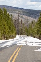
View looking down the MLH to the north from my turnaround point where the road became impassable
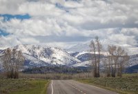
View of the high country looking south on the MLH with a long lens. I think the prominent high peak is probably A-1 or Kletting Peak.
View looking down the MLH to the north from my turnaround point where the road became impassable

View of the high country looking south on the MLH with a long lens. I think the prominent high peak is probably A-1 or Kletting Peak.

Hoobie
Member
- Joined
- Jan 28, 2013
- Messages
- 9
I was just checking the traffic camera on bald mountain pass and see that they've plowed the road on the pass today! http://udottraffic.utah.gov/1_devices/Bald-Mountain.gif?rand=0.130626874352901
- Joined
- Aug 8, 2016
- Messages
- 2,078
I was just checking the traffic camera on bald mountain pass and see that they've plowed the road on the pass today! http://udottraffic.utah.gov/1_devices/Bald-Mountain.gif?rand=0.130626874352901
Assumption... UDOT is plowing north from the Kamas side and there is heavy snow on the north-facing side yet to be cleared???
Sent from my iPhone using Tapatalk
- Joined
- Jun 25, 2012
- Messages
- 4,430
Don't assume. Investigate !Assumption... UDOT is plowing north from the Kamas side and there is heavy snow on the north-facing side yet to be cleared???
Sent from my iPhone using Tapatalk
(and report in..)
- Joined
- Aug 8, 2016
- Messages
- 2,078
Don't assume. Investigate ! [emoji4]
(and report in..)
Haha! I was actually heading up echo canyon last evening to look around. Was tempted to go but got too late. Maybe in a day or two [emoji102]
Sent from my iPhone using Tapatalk
- Joined
- Aug 8, 2016
- Messages
- 2,078
MLH is clear! Just came over. Pictures coming soon!
Sent from my iPhone using Tapatalk
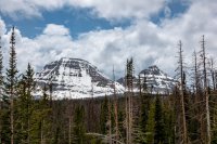
Ice covered Pass Lake with Mt Agassiz in the distance. All the lakes in this zone were pretty much 100% ice covered except Lost Lake.
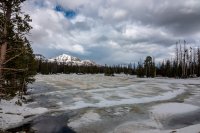
Mt Agassiz with snow covered meadow in the foreground...
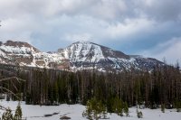
Looking back at the north faces of Bald Mountain and Reid's Peak. The south face of Bald Mountain was fairly snow free. Looked like the trail to the summit would be easily doable.
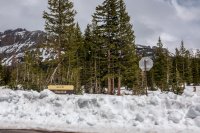
Highline Trail Head at Hayden Pass, approximately 10,300 ft., had a good three or more feet on the road into the parking area.
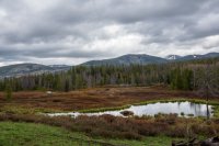
A bit lower in the area around Sulfur Campground the snow is all gone.
Last edited:
- Joined
- Jun 25, 2012
- Messages
- 4,430
Thanks, Perry! The Uintas are open for business!Ice covered Pass Lake with Mt Agassiz in the distance. All the lakes in this zone were pretty much 100% ice covered except Lost Lake.
View attachment 64486
Mt Agassiz with snow covered meadow in the foreground...
View attachment 64487
Looking back at the north faces of Bald Mountain and Reid's Peak. The west face of Bald Mountain was fairly snow free. Looked like the trail to the summit would be easily doable.
View attachment 64488
Highline Trail Head at Hayden Pass, approximately 10,300 ft., had a good three or more feet on the road into the parking area.
View attachment 64489
A bit lower in the area around Sulfur Campground the snow is all gone.
View attachment 64490
- Joined
- Jun 25, 2012
- Messages
- 4,430
From a former Highline crosser - I can’t think of any time between snow and the brunt of mosquitoe season. Most people can’t do many of the high passes with snow on them and that will be true until at least July probably. People with mountain skills and equipment are capable of doing it any time of course. The north side of the Dead Horse pass is generally regarded as the crux with snow on it but others are similar.Given the dry winter, any guesses to when the "sweet spot" will be between widespread snow cover and mosquitos this year? I'm trying to narrow in on a start date for the entire Highline Trail during the early season.
- Joined
- Aug 8, 2016
- Messages
- 2,078
I’ve been on the Highline twice the last two summers during the last week of August. Both times the mosquitos were pretty much nonexistent at that time. I would have to agree later is best as far as the bugs are concerned. You do miss the peak wild flower blooms and the lush green of early summer but the more golden hues are beautiful in their own right.
Sent from my iPhone using Tapatalk
Sent from my iPhone using Tapatalk
mathew
Member
- Joined
- Nov 10, 2013
- Messages
- 28
I have done the highline trail twice now and going again for the third time this year. I have always started the first weekend in August, never had a bug issue, and only ran into snow at gabbros pass once but it wasn't a problem to work around. My date is mostly chosen because of work scheduling as it is slowest at this point. I will be going into the granddaddy area in the middle of June and if it is anything like last year the mosquitoes will be fierce, learned to just avoid downed trees in the water and any stagnant water and they were manageable.
- Joined
- Aug 8, 2016
- Messages
- 2,078
Does anyone know how far you can get up into the basin below gun-sight pass on the Kings peak rout?. Also if coming from Crystal lake scenic rout how far up is snow/ how far can you get on any of those trails as we had a dryer winter...?
Being that Gunsight Pass is at almost 12,000 ft and it is north facing I'd feel pretty confident its still deep in snow. Even as far up Henrys Fork as Dollar lake is at 10,000 ft I'd bet there is still a lot of snow considering there is 3-4 feet on Hayden Pass which is at 10,000 ft. One additional factor is that generally the further east you go in the Uintas the less snow but at those elevations I'm sure its still snowshoe and ice ax territory.
As far as trails from the Crystal Lake trail head... Id bet they are still in snow yet. The road from MLH to Trial lake still had some snow on it as of last weekend. Probably passable to Trial but up higher I would say its a no-go unless you want to hoof it on snowshoes.
Last edited:
- Joined
- Aug 8, 2016
- Messages
- 2,078
Does anyone know how far you can get up into the basin below gun-sight pass on the Kings peak rout?. Also if coming from Crystal lake scenic rout how far up is snow/ how far can you get on any of those trails as we had a dryer winter...?
Light snow year for sure but still a decent amount of snow across the Uintas east and west. You'll still be postholing at 10k and encounter decent drifts above 9k.
View attachment 64535
Its the drifts that getcha
Don't like ads? Become a BCP Supporting Member and kiss them all goodbye. Click here for more info.

