Uintas Conditions 2017

Yeah I'm probably just getting eager ;p


Sent from my iPhone using Tapatalk
Hey, since we were up there last weekend and remembered we had been to Cuberant lake, why are you named Cuberant? What is the origin of the name?
 
Hey, since we were up there last weekend and remembered we had been to Cuberant lake, why are you named Cuberant? What is the origin of the name?

I just picked the name because it's a favorite of my Dad. He has always told me about his many fishing trips into the basin with his uncles long before I was born. Seemed fitting as he's the one who got me into fishing and backpacking.

On the name itself I think I've read it's a Ute word for long. Seems to fit with the shape of the lake.


Sent from my iPhone using Tapatalk
 
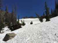
I did a loop today up in the lakes area. Dropped a bike off at the Crystal Lake trailhead, and then drove up to the summit. I did the Notch trail from the summit, down around Notch Mountain, Ibantik Lake, over the Notch and then back to the Crystal Lake trailhead where I picked up my bike, and then biked back up to my car at the summit. Still loads of snow up there. All the lakes are thawed out but I was constantly having to walk over or around snow drifts, anywhere from 6 inches to 3-4 feet. The pass at the notch was completely locked in with snow on the North side, thankfully I had traction devices with me. I've done parts of this trail and the end of June before and never had even close to this much snow. It's still going to be a few weeks till most of the upper basins are really thawed out.
 
I did a loop today up in the lakes area. Dropped a bike off at the Crystal Lake trailhead, and then drove up to the summit. I did the Notch trail from the summit, down around Notch Mountain, Ibantik Lake, over the Notch and then back to the Crystal Lake trailhead where I picked up my bike, and then biked back up to my car at the summit. Still loads of snow up there. All the lakes are thawed out but I was constantly having to walk over or around snow drifts, anywhere from 6 inches to 3-4 feet. The pass at the notch was completely locked in with snow on the North side, thankfully I had traction devices with me. I've done parts of this trail and the end of June before and never had even close to this much snow. It's still going to be a few weeks till most of the upper basins are really thawed out.

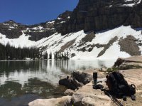
The snow in the west end is definitely impressive.


Sent from my iPhone using Tapatalk
 
Crossing fingers trail to Allsop is mostly dry come mid July. Also hoping the snow isn't all that bad on 'Cathedral Pass' so we can loop in Priord for a night as well.
 
anybody know if the trail up to amethyst lake is mostly snow free? gonna head up there in 10 days or so, what are the conditions looking like? (utah, Uintas area)
 
Last edited:
Word is that the mosquitoes are out in force in the Unitas...surprise surprise.
I'll be headed up to Amethyst Lake this Saturday for a day hike. I'm sure there won't be anyone else up there with me!
 
Word is that the mosquitoes are out in force in the Unitas...surprise surprise.
I'll be headed up to Amethyst Lake this Saturday for a day hike. I'm sure there won't be anyone else up there with me!
Spent last night up at Jewel lake, hardly any mosquitoes to be found. Saw a couple here and there, but I am sure by next weekend they will be out in full force.
 
We were thinking of taking the kids into Grandaddy basin this weekend - Anybody been near the Grandview trail head recently? It's sounding like there might be quite a bit of snow still, at least over hades?
 
We were thinking of taking the kids into Grandaddy basin this weekend - Anybody been near the Grandview trail head recently? It's sounding like there might be quite a bit of snow still, at least over hades?
I called the ranger station a week or two ago about access for the southern trailhead to granddaddy basin. They said it would be closed until the first week of July except to logging crews who are removing trees
 
Question for the experienced early-season Uintas folks. We've been considering a south-to-north crossing of the central Uintas for early July, perhaps leaving about the 5th or so. The route would be from Center Park through Garfield Basin, over Smiths Fork Pass, and out at China Meadows. I'm concerned that the route would hit some difficult snow conditions in early July, especially this year. What do you guys think? Any thoughts would be appreciated.
 
Question for the experienced early-season Uintas folks. We've been considering a south-to-north crossing of the central Uintas for early July, perhaps leaving about the 5th or so. The route would be from Center Park through Garfield Basin, over Smiths Fork Pass, and out at China Meadows. I'm concerned that the route would hit some difficult snow conditions in early July, especially this year. What do you guys think? Any thoughts would be appreciated.

Your chances go way up further east in the range. Less snow falls out there and it usually melts out a lot faster. The passes aren't usually as steep either.
 
Question for the experienced early-season Uintas folks. We've been considering a south-to-north crossing of the central Uintas for early July, perhaps leaving about the 5th or so. The route would be from Center Park through Garfield Basin, over Smiths Fork Pass, and out at China Meadows. I'm concerned that the route would hit some difficult snow conditions in early July, especially this year. What do you guys think? Any thoughts would be appreciated.
I believe there will only be significant snow on the north sides of the passes. It will be soft late in the afternoons, maybe, and possible to plunge step or sitting-glissade safely, maybe. If it is hard it will be technical requiring an ice axe belay or self arrest. All depends on conditions and steepness so be prepared for all of the above or be prepared to turn back if it is unsafe. Going by memory, Smith Fork Pass is not horribly steep on either the south or north. Reports are that snow is off all the way to Lower Red Castle Lake so I think the only snow you will have is at the divide and the crux is the north side of the pass.

I am heading to backpack in to the Leidy Peak area this weekend to over 11K', probably, and will be back to put in a post here on the third. This is on the far east end which is snow starved compared to the west or even Red Castle Peak area.
 
Last edited:
Many thanks, Art ... that's kind of what I was suspecting.

The ice ax is staying home this trip, so we might just do an out-and-back to the Red Castle area, and see how things look.
 
I'm planning on fishing a few of the streams up in the High Uintas in about a week...will they still be too high/unfishable from runoff or should they be fine? (its ok if they're high, just not good if they are off color)
 
Back
Top