Navigation
Install the app
How to install the app on iOS
Follow along with the video below to see how to install our site as a web app on your home screen.
Note: This feature may not be available in some browsers.
More options
Style variation
You are using an out of date browser. It may not display this or other websites correctly.
You should upgrade or use an alternative browser.
You should upgrade or use an alternative browser.
Uintas Conditions 2017
- Thread starter Dave
- Start date
- Joined
- Jul 23, 2013
- Messages
- 1,665
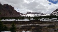
Up at East Fork tonight. Snow is coming off fast. Three weeks ago the peaks were solid white. Now there's rock breaking through. Headed up MLH tomorrow to see how close they are to clearing the pass.
Pretty sure they broke through all the way on MLH this last week.
- Joined
- May 5, 2012
- Messages
- 1,732
Pretty sure they broke through all the way on MLH this last week.
Yeah, it's clear all the way. It officially opens tomorrow at 9 a.m. but people were driving over today.
The machines are parked at Butterfly Lake right now.
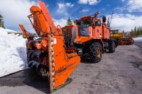
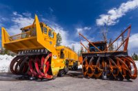
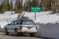
All of the trailheads and campgrounds above 10k feet are still snowbound. There's 3-5 solid feet of snow above 10k feet, spotty snow down to about 9,500 feet.
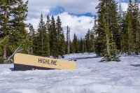
Did a loop walk today from Butterfly up to Lofty Lake, down to Cutthroat and then back via Ruth.
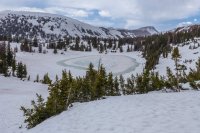
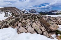
Very minor postholing late in the afternoon, otherwise good firm walking snow.
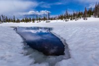
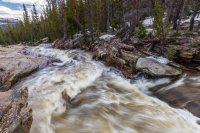
It will go fast but I never remember seeing so much snow up there in June before. Provo River Falls is absolutely raging right now.
- Joined
- Aug 8, 2016
- Messages
- 2,078
Well I just got back from a recon of the North Slope Road from MLH. Snow at 10,000 ft just short of Elizabeth Pass. Soooo close and it's a sloppy mess.
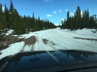
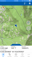
I'm guessing the pass will be clear in a week or two. Not good news for our plans to try to get into the trail heads this weekend though. Question though is it open from the Fort Bridger side? Might have to call the Mountain View?? Ranger District and see what they know.
The snow aside there is an insane amount of water up there right now. Every creek and river is flooding. Water is everywhere.
uintafly
Member
- Joined
- Mar 1, 2012
- Messages
- 109
I am thinking of taking the kids up there this weekend for a few nights. For those of you who have been up this year, how is the camping down a little lower? Typically this time of year I'll just pull off somewhere between Soapstone Basin and Murdoch Basin. How are conditions at that elevation? I am guessing snow is gone, but how muddy is it at that point?
- Joined
- Aug 8, 2016
- Messages
- 2,078
I am thinking of taking the kids up there this weekend for a few nights. For those of you who have been up this year, how is the camping down a little lower? Typically this time of year I'll just pull off somewhere between Soapstone Basin and Murdoch Basin. How are conditions at that elevation? I am guessing snow is gone, but how muddy is it at that point?
Snow is pretty much gone below about 9500 ft. Question will be mud and water with everything running high. I'm sure you can find something reasonable though
Sent from my iPhone using Tapatalk
uncleblake7
New Member
- Joined
- Jun 11, 2017
- Messages
- 2
Hey all! I've been planning a little 3-day 2-night trip from Christmas Meadows to Ostler Lake then to Amethyst Lake for June 15-17. I've been watching the snow levels at Bald Mountain Pass (10,700 feet) and Amethyst Lake is at about the same elevation. The weather station at Bald Mountain Pass shows snow levels melting at about 3" per day, but would still be at about a foot and a half by the time we go. Snow levels appear to be similarly high in the Amethyst Lake basin and Ostler Lake basin when I look at the NOHRSC snow-depth Google Earth overlays.
1. Has anyone been up that way recently that could report on the conditions?
2. Realistically, its looking like I'm going to have to postpone the Amethyst Lake trip until things dry-out a bit more. I've still got a group of anxious backpackers looking forward to a fun trip this week. Any recommendations for a 3-day 2-night 10-20 mile trip in the Wasatch or Uinta mountains?
Thanks!
Blake
- Joined
- Aug 9, 2007
- Messages
- 12,959
Hey all! I've been planning a little 3-day 2-night trip from Christmas Meadows to Ostler Lake then to Amethyst Lake for June 15-17. I've been watching the snow levels at Bald Mountain Pass (10,700 feet) and Amethyst Lake is at about the same elevation. The weather station at Bald Mountain Pass shows snow levels melting at about 3" per day, but would still be at about a foot and a half by the time we go. Snow levels appear to be similarly high in the Amethyst Lake basin and Ostler Lake basin when I look at the NOHRSC snow-depth Google Earth overlays.
1. Has anyone been up that way recently that could report on the conditions?
2. Realistically, its looking like I'm going to have to postpone the Amethyst Lake trip until things dry-out a bit more. I've still got a group of anxious backpackers looking forward to a fun trip this week. Any recommendations for a 3-day 2-night 10-20 mile trip in the Wasatch or Uinta mountains?
Thanks!
Blake
Heading much further east will usually get you into the high elevations faster than that area. Just because the Trial Lake snotel says X number, keep in mind that that's just a gauge in a relatively open space. That doesn't mean that everything at that level is melted out. Even on a low snow year, having a mostly snow-free trip to Amethyst Lake by June 15th rarely happens. On a good year like this, you'd be better off to plan on the first or second week of July.
Deleted User
Deleted User
- Joined
- Aug 5, 2016
- Messages
- 294

My buddy Grady shot this today up at Trial Lake. Huge bergs still in there. But it looks like the ice is starting to come off.
Deleted User
Deleted User
- Joined
- Aug 5, 2016
- Messages
- 294
Hey all! I've been planning a little 3-day 2-night trip from Christmas Meadows to Ostler Lake then to Amethyst Lake for June 15-17. I've been watching the snow levels at Bald Mountain Pass (10,700 feet) and Amethyst Lake is at about the same elevation. The weather station at Bald Mountain Pass shows snow levels melting at about 3" per day, but would still be at about a foot and a half by the time we go. Snow levels appear to be similarly high in the Amethyst Lake basin and Ostler Lake basin when I look at the NOHRSC snow-depth Google Earth overlays.
1. Has anyone been up that way recently that could report on the conditions?
2. Realistically, its looking like I'm going to have to postpone the Amethyst Lake trip until things dry-out a bit more. I've still got a group of anxious backpackers looking forward to a fun trip this week. Any recommendations for a 3-day 2-night 10-20 mile trip in the Wasatch or Uinta mountains?
Thanks!
Blake
The Wasatch lower elevations have melted out. But above 9,500 ft you are going to have deep snow. Snowbird just had its closing day today if that gives you an idea on the snow pack at upper elevations. If you are going to canyon traverse to do that kind of mileage, you are going to have to deal with deep snow. I'd say by the 4th of July the Wasatch will be mostly melted out.
As for the Uintas, not only are you gonna have snow all the way to Amethyst, you are also going to have some serious water crossings before you even get to the junction to Ostler Fork. There are several places where the water crosses the trail on the way to the junction. Some of them require some navigation on a low water year. I expect they are a raging torrent at the moment. By next weekend? With the heat expected, I would bet it gets close to flood stage in there. I already told myself the Uintas are gonna be a July thing.
- Joined
- May 31, 2015
- Messages
- 3,327
Maybe look into the Deseret Peak Wilderness over by Tooele. I've been there in other heavy-snow years, and it always melts out earlier than other popular mountain areas. Fantastic trails and views. Looking at the snow maps, the area looks to be mostly snow-free. I've encountered a bit of snow there the first week of June, but it was no impediment. Made for some nice glissading.Hey all! I've been planning a little 3-day 2-night trip from Christmas Meadows to Ostler Lake then to Amethyst Lake for June 15-17. I've been watching the snow levels at Bald Mountain Pass (10,700 feet) and Amethyst Lake is at about the same elevation. The weather station at Bald Mountain Pass shows snow levels melting at about 3" per day, but would still be at about a foot and a half by the time we go. Snow levels appear to be similarly high in the Amethyst Lake basin and Ostler Lake basin when I look at the NOHRSC snow-depth Google Earth overlays.
1. Has anyone been up that way recently that could report on the conditions?
2. Realistically, its looking like I'm going to have to postpone the Amethyst Lake trip until things dry-out a bit more. I've still got a group of anxious backpackers looking forward to a fun trip this week. Any recommendations for a 3-day 2-night 10-20 mile trip in the Wasatch or Uinta mountains?
Thanks!
Blake
Otherwise, the low elevation mountains, like below Timp's west face and Provo Peak's west face, are clear and you could do a route through there.
Or, as Nick often recommends, head to the desert!
- Joined
- May 5, 2012
- Messages
- 1,732
This is what the snow looked like on Sunday just below Red Castle Lake...
Nice! How were trail conditions?
- Joined
- Aug 8, 2016
- Messages
- 2,078
Nice! How were trail conditions?
Muddy in places, some small patches of snow. Many long stretches where it was absolutely dry. If one would be satisfied to stop at Lower Red Castle Lake I'd say it's a 100% go. Any higher then the snow varies from annoying to not being able to follow the trail at all. We snowshoed the latter half on our attempt to get to Red Castle Lake but it was pretty miserable. Very slushy. Also had put the snowshoes on and off quite a bit. This part was mostly in the trees so I'm betting its going to be another 30 days or so before that's truly open.
- Joined
- Aug 8, 2016
- Messages
- 2,078
Last edited:
uncleblake7
New Member
- Joined
- Jun 11, 2017
- Messages
- 2
Thanks everyone for your replies! I think we'll shoot for the Deseret Peak Wilderness. I'll let you know how it goes.
- Joined
- Aug 8, 2016
- Messages
- 2,078
Thanks everyone for your replies! I think we'll shoot for the Deseret Peak Wilderness. I'll let you know how it goes.
Please do. Deseret Peak is on my bucket list for this year.
- Joined
- May 31, 2015
- Messages
- 3,327
Awesome!! You won't be disappointed. It's an incredible area that most people overlook.Thanks everyone for your replies! I think we'll shoot for the Deseret Peak Wilderness. I'll let you know how it goes.
Last edited:
Don't like ads? Become a BCP Supporting Member and kiss them all goodbye. Click here for more info.

