DrNed
The mountains are calling and I must go
- Joined
- Mar 31, 2013
- Messages
- 1,026
After having such a great time in the Uintas this summer on a week long adventure with my kids, I wanted to get out for another multi day trip before it got cold. We decided on the week of September 16.
I recruited my friend Jerry, and after enjoying the pictures & trip reports here on BCP I decided on trip to the Amythest & Middle Basins. During trip planning this was going to be a four day / three night trip. Due to work demands we ended up with a three day / two night trip.
We started out early from the Christmas Meadows Trailhead. Notice the message on the top right of trailhead sign.

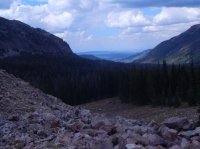
I say notice because within :20 minutes of hiking we ran into this.

After working our way around this mess, the trail is fairly easy with only small rises & falls. My excitement was high and I was feeling good. After a few miles we reached the fork in the trail where one goes to the Amythest Basin, the other to the Middle Basin. We followed the trail to Amythest.

Shortly after passing the fork there is a nice little fall.

The trail from here into the basin is quite steep and rocky. I don't know if it is always this way or just the time of the year, but from here up, there was quite a bit of water & muck - which really slowed the travel down, got my feet wet and I started chaffing in my groin and getting blisters on the inside of both heels.
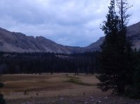
By the time we reached the meadow at the entrance into the basin I was ready to get rid of my back and sit for awhile.

From here we went up the hill to the right and found a nice spot and set up camp.

As much as I like lake side camping this really was a great spot. It was flat, off the the trail, and we had the river just below to serenade us.

After setting up camp, getting some food in me I was feeling refreshed and ready to do some exploring.
We wandered on and off trail finding BR-24 first.

After walking around BR-24 we got back on the trail towards Amythest. On the way we spotted this guy.

He was so patient.

I'm not very quiet or a very good photographer, but he did a good job of standing there while I fumbled around and finally got a few good shots. After which he calmly walked away.

The hike from here turns out to be easy and the driest part of the trail.
We finally arrive at Amythest Lake. I love how many of these High Uinta Lakes sit in castle like cirques, showing off their majesty.


Until some bozo gets in the way, messing with their beauty.

An outlet from Amythest. For some reason I just loved this view.

This is a view down canyon, just below Amythest.

Unfortunately, I don't know my directions here. So while looking down canyon we went to the left from here and climbed up this rocky ridge to see what there was to see.
I think this is a moraine.

We climbed up just below Amythest and followed this all the way down to BR-24.
My friend Jerry is much quicker than I, so he would get ahead and look around while he waited for me.

Messing with the natural beauty of things again.

Once we got to BR-24 again, we went further up the mountain in search of Ostler Lake.

Here we sat down for awhile and took a little nap. Until it started raining on us.

Because the trip had been cut a day short we got up the next morning, broke camp and got on the trail towards Middle Basin. It rained a good part of the night so the muck is in full force the next morning.
After backtracking to the fork, we're on our way to Middle Basin. Shortly after passing the fork you must cross the river on a ramshackle bridge. From what I understand this bridge is not always in and is purely user maintained. I'm glad it was in because the amount of water going through here at this time, if I wasn't I don't know that we could have made it across.

As we progressed on the trail the muck got worse, as did the way I was feeling mentally and physically.
It started raining and hailing pretty good, so we stepped into a stand of pines and got our rain gear on.

Unfortunately I did not prepare for this trip as well as I should have. I looked at the map of course, but I didn't do any distance calculations so I didn't have any real ideas of how far I had to go to reach the basin. As the trail & weather worsened I had had enough. So once we reached the spot where the trail splits between Middle and West Basins, we got off trail and set up camp.
I had some good blisters, chaffing and mud up to my thighs. Again, though after sitting down for about :30 minutes, eating and debating what the weather was going to do, I was feeling refreshed and we took the risk and headed up towards Ryder & McPheter's lakes and in this case, the eye of the storm.
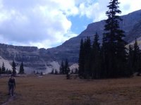
Unfortunately the muck did not improve, but the weather did and we finally reached the meadow.
I wouldn't say the hike was difficult, but it was tough. There's a rock strewn chute that you must navigate to reach the basin that turns away all but the truly committed - and mine was wavering.
But persevere we did and no doubt about it - it was worth it. There's something about high mountain meadows that really does it for me . . . and this was in September when most everything was brown. I can only imagine the grandeur with warm, sunny, blue skies, green grass and blooming flowers.


The bad news - it was 7:30 PM by now and we had two hours of hiking down in front of us to reach camp, so unfortunately we never made it to either of the named lakes. There were several ponds in this wide open meadow.
Fortunately for me I had a reliable partner on this trip who was able to guide us down in the dark. Just before reaching camp the skies cleared and the moon came up behind us. A full moon, just over the mountains is an amazing sight.
We ate, got to bed and woke up the next morning to the best weather all week. We packed up and hiked down to the trailhead and called it a trip.

If you're considering doing this trip, and I strongly suggest you do, do your distance calculations it's a ways in. Be prepared for lousy trail conditions and give yourself more time to fully consume this Uinta gem. The advice I would give to my past self - suck it up and camp by the lakes it will be worth it.
I recruited my friend Jerry, and after enjoying the pictures & trip reports here on BCP I decided on trip to the Amythest & Middle Basins. During trip planning this was going to be a four day / three night trip. Due to work demands we ended up with a three day / two night trip.
We started out early from the Christmas Meadows Trailhead. Notice the message on the top right of trailhead sign.
I say notice because within :20 minutes of hiking we ran into this.
After working our way around this mess, the trail is fairly easy with only small rises & falls. My excitement was high and I was feeling good. After a few miles we reached the fork in the trail where one goes to the Amythest Basin, the other to the Middle Basin. We followed the trail to Amythest.
Shortly after passing the fork there is a nice little fall.
The trail from here into the basin is quite steep and rocky. I don't know if it is always this way or just the time of the year, but from here up, there was quite a bit of water & muck - which really slowed the travel down, got my feet wet and I started chaffing in my groin and getting blisters on the inside of both heels.
By the time we reached the meadow at the entrance into the basin I was ready to get rid of my back and sit for awhile.
From here we went up the hill to the right and found a nice spot and set up camp.
As much as I like lake side camping this really was a great spot. It was flat, off the the trail, and we had the river just below to serenade us.
After setting up camp, getting some food in me I was feeling refreshed and ready to do some exploring.
We wandered on and off trail finding BR-24 first.
After walking around BR-24 we got back on the trail towards Amythest. On the way we spotted this guy.
He was so patient.
I'm not very quiet or a very good photographer, but he did a good job of standing there while I fumbled around and finally got a few good shots. After which he calmly walked away.
The hike from here turns out to be easy and the driest part of the trail.
We finally arrive at Amythest Lake. I love how many of these High Uinta Lakes sit in castle like cirques, showing off their majesty.
Until some bozo gets in the way, messing with their beauty.
An outlet from Amythest. For some reason I just loved this view.
This is a view down canyon, just below Amythest.
Unfortunately, I don't know my directions here. So while looking down canyon we went to the left from here and climbed up this rocky ridge to see what there was to see.
I think this is a moraine.
We climbed up just below Amythest and followed this all the way down to BR-24.
My friend Jerry is much quicker than I, so he would get ahead and look around while he waited for me.
Messing with the natural beauty of things again.
Once we got to BR-24 again, we went further up the mountain in search of Ostler Lake.
Here we sat down for awhile and took a little nap. Until it started raining on us.
Because the trip had been cut a day short we got up the next morning, broke camp and got on the trail towards Middle Basin. It rained a good part of the night so the muck is in full force the next morning.
After backtracking to the fork, we're on our way to Middle Basin. Shortly after passing the fork you must cross the river on a ramshackle bridge. From what I understand this bridge is not always in and is purely user maintained. I'm glad it was in because the amount of water going through here at this time, if I wasn't I don't know that we could have made it across.
As we progressed on the trail the muck got worse, as did the way I was feeling mentally and physically.
It started raining and hailing pretty good, so we stepped into a stand of pines and got our rain gear on.
Unfortunately I did not prepare for this trip as well as I should have. I looked at the map of course, but I didn't do any distance calculations so I didn't have any real ideas of how far I had to go to reach the basin. As the trail & weather worsened I had had enough. So once we reached the spot where the trail splits between Middle and West Basins, we got off trail and set up camp.
I had some good blisters, chaffing and mud up to my thighs. Again, though after sitting down for about :30 minutes, eating and debating what the weather was going to do, I was feeling refreshed and we took the risk and headed up towards Ryder & McPheter's lakes and in this case, the eye of the storm.
Unfortunately the muck did not improve, but the weather did and we finally reached the meadow.
I wouldn't say the hike was difficult, but it was tough. There's a rock strewn chute that you must navigate to reach the basin that turns away all but the truly committed - and mine was wavering.
But persevere we did and no doubt about it - it was worth it. There's something about high mountain meadows that really does it for me . . . and this was in September when most everything was brown. I can only imagine the grandeur with warm, sunny, blue skies, green grass and blooming flowers.
The bad news - it was 7:30 PM by now and we had two hours of hiking down in front of us to reach camp, so unfortunately we never made it to either of the named lakes. There were several ponds in this wide open meadow.
Fortunately for me I had a reliable partner on this trip who was able to guide us down in the dark. Just before reaching camp the skies cleared and the moon came up behind us. A full moon, just over the mountains is an amazing sight.
We ate, got to bed and woke up the next morning to the best weather all week. We packed up and hiked down to the trailhead and called it a trip.
If you're considering doing this trip, and I strongly suggest you do, do your distance calculations it's a ways in. Be prepared for lousy trail conditions and give yourself more time to fully consume this Uinta gem. The advice I would give to my past self - suck it up and camp by the lakes it will be worth it.
")

")