Calculating Distance

DrNed

The mountains are calling and I must go
Joined
Mar 31, 2013
Messages
1,025
Ok so this is a complete noob question, but here goes . . . I'm planning some trips and I want to know what my distances are. This past fall I went up to the Middle Basin in the Unitas and I made this mistake of not calculating the distance (I am EVER going to get there?). Trying to avoid that frustration again. So how do I calculate distance, without ever having been there and without laying a piece of string along the trail on my Nat Geo trails illustrated map? (surely I'm not the only one who has done that?!)
 
Google Maps used to be great for this but for some strange reason they removed the distance when you draw a line in the 'new and improved' Google Maps Engine. Google Earth still has a nice measuring tool though. If you want a topo, you can download a layer that you can put into GE or you can just use sat view which is what I do a lot. Just figure that whatever line you draw on a map, the actual distance will be greater. Even if you follow a long the trail, your drawn line will inevitably have less variance than what your feet will actually walk. When I do a really rough line, I figure actual distance will come out 20-30% higher.
 
Yep, I use Google Earth for this. That being said, physical distance is sometimes secondary to psychological factors when it comes to the perception of distance. I find trail location, terrain, weather and scenery are big influencers in the are-we-there-yet condition.
 
I use the knuckle of my finger on a map...how's that for high tech? :)

When I want more exact distances, I use my Delorme TopoUSA software.

And I totally agree with @ashergrey about the effect of perception on the distance. It always takes me at least 25% longer to hike in than it does to hike out on an out-and-back. And when a trail sucks, it seems to last forever.
 
@Nick how would I load a topo into GE? Is in it self explanatory?
@ashergrey & @Aldaron I completely agree. The middle basin trip I referenced was 10 miles
of muck & rocks without knowing how much further I had to go had me in
"whiny 6 year old" mode. If I had been better prepared mentally for
how long I was going to be hiking with my pack, I would have done better.

Thanks
 
@Nick how would I load a topo into GE? Is in it self explanatory?


Download the file at the bottom of this post and open it in Google Earth. ;)

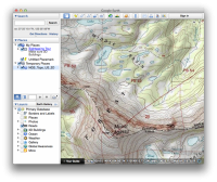
The resolution isn't as good as the topo on the BCP Topo Map, but it is nice for doing distances. You can turn it on and off on the panel on the left side.

Screen Shot 2013-12-04 at 7.59.21 PM.png
 

Attachments

  • NGS_Topo_US_2D.kmz
    848 bytes · Views: 21
You can use Gmap it combines google maps and topo maps for you. It is free and the best online mapping tool I have found. I use it all the time to embed topo maps into trip reports. To get route distances, go to menu and select "Draw and Save". You can even output your routes to a GPX file which you can load into your GPS.
 
I used to use gmap a lot but in conjunction with the old Google Maps. I'm pretty unimpressed with the planning/route drawing tool available there. We still use it to do trip report map embeds here on BCP though.
 

Similar threads

Back
Top