Navigation
Install the app
How to install the app on iOS
Follow along with the video below to see how to install our site as a web app on your home screen.
Note: This feature may not be available in some browsers.
More options
Style variation
You are using an out of date browser. It may not display this or other websites correctly.
You should upgrade or use an alternative browser.
You should upgrade or use an alternative browser.
Album Panoramas and Stitched Images
- Thread starter xjblue
- Start date


Michael
Alien from over the pond...
- Joined
- Sep 5, 2012
- Messages
- 1,042
Oh no, Henk,
The Smokey Mtn rd isn't really designed for RVs.")
We hired a 4WD in Page, AZ. Headed up the Cottonwood Canyon rd, played along Hole in the Rock rd and went back to Page via Smokey Mnt rd.
Gesendet von meinem iPadAir mit CrapaTalk
The Smokey Mtn rd isn't really designed for RVs.
We hired a 4WD in Page, AZ. Headed up the Cottonwood Canyon rd, played along Hole in the Rock rd and went back to Page via Smokey Mnt rd.
Gesendet von meinem iPadAir mit CrapaTalk
xjblue
Member
- Joined
- Sep 6, 2012
- Messages
- 370
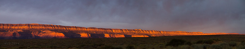
Fifty Mile Sunrise by xjblue, on Flickr
Playing with the "Light Room > edit in > merge to panorama in Photoshop" process lately. From five images.

") . This was taken just this morning as the sun cracked the hills in the badlands of Alberta. Frost from a chilly evening caught the light just right I think.
. This was taken just this morning as the sun cracked the hills in the badlands of Alberta. Frost from a chilly evening caught the light just right I think. 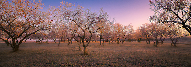
Vegan.Hiker
Member
- Joined
- Jul 5, 2014
- Messages
- 2,099
White Mountains, NH - Carter Dome (left) and Mount Washington (right) taken from the summit of Mount Hight.

Curt
Member
- Joined
- Feb 1, 2014
- Messages
- 426
I really like panoramas and first discovered stitching about 3 years ago. I've mad a lot of mistakes and I'm slowly getting better at it, but I think I've got a long way to go before I get to the excellence of so many of the pictures on this thread. I'm honestly in awe of how good many of these pictures are.
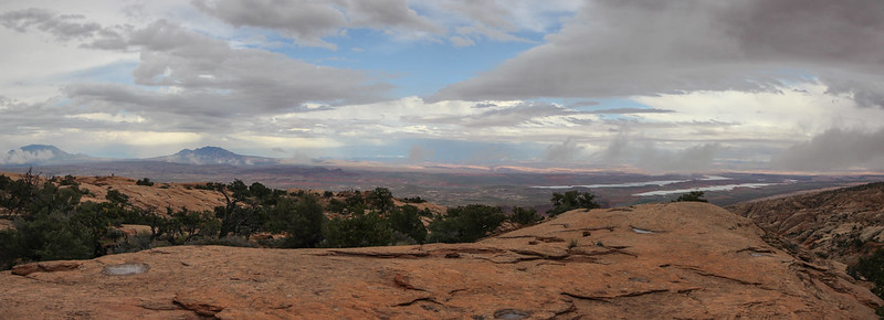
Anyway, I thought I'd post some of my own here. Went to Canyonlands last month. This is from the overlook over Salt Creek Canyon on the peninsula on Bridger Jack Mesa near Cathedral Butte.

Anyway, I thought I'd post some of my own here. Went to Canyonlands last month. This is from the overlook over Salt Creek Canyon on the peninsula on Bridger Jack Mesa near Cathedral Butte.

- Joined
- Jul 23, 2013
- Messages
- 1,666
I let Google Photos do all the stitching for me. I'm finding myself resorting to it more than my camera's pano mode or doing it by hand. Here's a few recent ones to add to the gallery here...
Silver Lake Flat (June 2015)

Mount Timpanogos from Christ Flat (June 2015)

Morat Lakes in Naturalist Basin (June 2015)
Silver Lake Flat (June 2015)
Mount Timpanogos from Christ Flat (June 2015)
Morat Lakes in Naturalist Basin (June 2015)
- Joined
- Jun 25, 2012
- Messages
- 4,433
Kluane Lake ! Hey i've been there! On a trip to AK. We flew a small plane over the St. Elias range from there. Phenomenal. Why were you there?A calm day at Destruction Bay. Kluane Lake, Yukon Territory, Canada.View attachment 29867
BTW Great pano!
Curt
Member
- Joined
- Feb 1, 2014
- Messages
- 426
My wife wanted to do something special for our 30th anniversary and decided we should go to Alaska. We ended up going on a tour. When I saw the itinerary I thought that the some of the things on the tour would make me gag - too touristy. But it all ended up being good. Even the worst of the touristy stuff. Anyway, we stopped at Destruction Bay for lunch. I was blown away by the view. While everyone else was in eating lunch I was outside taking pictures. My wife made sure they didn't leave me there! I would really like to go back someday.Kluane Lake ! Hey i've been there! On a trip to AK. We flew a small plane over the St. Elias range from there. Phenomenal. Why were you there?
BTW Great pano!
Would have loved to have been able to fly over the St. Elias range. I thoroughly believe you when you say that it was phenomenal.
- Joined
- Jul 23, 2013
- Messages
- 1,666
This week was my 6 year old's turn for a daddy-daughter trip. We backpacked the "Seventeen Lakes" loop trail and hit the Notch yesterday morning. Full TR coming soon. In the mean time, here's the pano view off the Notch looking south.

slc_dan
Desert Rat-Weekend Warrior
- Joined
- Jun 7, 2012
- Messages
- 1,687
I'm finally getting around to piecing together a TR that @Nick helped me out with on this trip.
Here's a stitch from when I (finally) reached the top of the Waterpocket Fold with no help of a route.
Top of the Fold by slc_dan, on Flickr
Here's a stitch from when I (finally) reached the top of the Waterpocket Fold with no help of a route.
Top of the Fold by slc_dan, on Flickr
Last edited:
Curt
Member
- Joined
- Feb 1, 2014
- Messages
- 426
View east from Scottsbluff in western Nebraska. Ruts from the wagon trains on the Oregon Trail making their way to Mitchell Pass 150 to 180 years ago can be seen running just to the left of the walking path. More ruts are visible between the gullies on the lower left of the picture. The butte standing alone on the left side of the picture is Dome Rock. Crown Rock is the promontory extending closest to the Visitor Center to its left. The looping road passes through the back of Eagle Rock and Sentinel Rock is the high point immediately beyond Eagle Rock. The route of the Oregon Trail passed between Eagle and Sentinel Rocks at Mitchell Pass. About a quarter of a million people passed this way between 1830 and 1860 on the first real thru hike (self supported) in North America long before the AT, CDT, and PCT.

Cool Danish
Member
- Joined
- Jan 13, 2013
- Messages
- 136
Very cool.. do you mind sharing the exact location by Lake Powell?Three panoramics shot at Lake Powell.
View attachment 33321
View attachment 33320
View attachment 33319
- Joined
- Aug 9, 2007
- Messages
- 12,967
Three panoramics shot at Lake Powell.
Cookie Jar Butte! I'd bet you were standing somewhere around here:
https://www.google.com/maps/place/3...8039,315m/data=!3m2!1e3!4b1!4m2!3m1!1s0x0:0x0
Close?