- Joined
- May 5, 2012
- Messages
- 1,732
I am continuing to update an online map with information as I get it (so positions are subject to change).
(Edit: Map link removed)
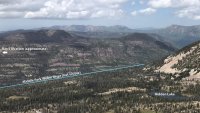
For people who are unfamiliar with the area, this shot shows the general area as seen from the northeast ridge of Mount Watson. The camera is looking west-northwest. The gorge of the Middle Fork Weber River runs laterally across the frame. Ray had to have crossed that gorge (and the river) to reach the spot from which he was recovered.

Last edited:

