Guess the spot: Utah Edition

The best scenic road in the country is Highway 12, not biased at all... This did look Boulder Mtn to me, but I was also thinking it could have been up by Fish Lake and Pando...

I only have a wag though cuz I have not camped on the south side of Boulder Mountain yet, and this seems like the south side.
Deer Creek Lake Trailhead?
Yes, on the road, it is also the best motorcycle road in the nation - from this 1.1 million mile driver.

i tried, and failed, to find the Boulder creek lake trailhead or the Boulder creek lake for that matter. That was quite the rabbit hole I got lost down. Humans are poor at naming things, just like cottonwood canyon my search for Boulder creek ended up with innumerable results none of which helped. :) so, Ugly, can’t give it to you. Yet,
 
Yes, on the road, it is also the best motorcycle road in the nation - from this 1.1 million mile driver.

i tried, and failed, to find the Boulder creek lake trailhead or the Boulder creek lake for that matter. That was quite the rabbit hole I got lost down. Humans are poor at naming things, just like cottonwood canyon my search for Boulder creek ended up with innumerable results none of which helped. :) so, Ugly, can’t give it to you. Yet, wait, hold one, I need to repeat for the name deer creek! Doh...
Well that was a more satisfying search. Found it and I suppose you mean the trailhead on Sunflower Flat which is a place I am familiar with. This is an approved location for byu to build a dark sky observatory. Or was. Nope Ugly, close. The spot IS near several trailheads and a delightful established campground I’ve used with the Germans, @Michael and his wife.
 
Last edited:
Can’t remember to the exact name of this spot near Pleasant Creek. It’s a very picturesque place.


Gesendet von iPad mit Tapatalk
 
So it's established this is near Pleasant Creek but want something closer? Wildcat Creek? Rosebud ATV campground? Oak Creek campground? Lower PC Campground? FR 168? :)
 
So it's established this is near Pleasant Creek but want something closer? Wildcat Creek? Rosebud ATV campground? Oak Creek campground? Lower PC Campground? FR 168? :)
I figured you‘d weigh in Will since you frequent the area and also, you, Michael because you do too! This picture is from the road, HWY 12, first left turn south of the Pleasant Creek campground turnoff (the FS road turning off down to Lower Browns reservoir. It is a reliable place for aspen beauty in the fall, or winter or summer or spring. So I am going to say GO @Michael since he was a couple of hours before you @WasatchWill. Sorry.
 
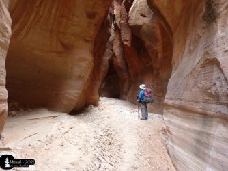
From picturesque trees to the magical sandstone - name the canyon.

GTS_UE04.jpeg
 
Neither of them, Greg. :)


Gesendet von iPad mit Tapatalk
 
…is to far in the northeast. :)


Gesendet von iPad mit Tapatalk
 
Brimstone - unfortunately no. :)
BVG is closer than the other two here mentioned.
That canyon is remote. The remnants of an old Utahn SR are in the near.
 
I figured you‘d weigh in Will since you frequent the area and also, you, Michael because you do too! This picture is from the road, HWY 12, first left turn south of the Pleasant Creek campground turnoff (the FS road turning off down to Lower Browns reservoir. It is a reliable place for aspen beauty in the fall, or winter or summer or spring. So I am going to say GO @Michael since he was a couple of hours before you @WasatchWill. Sorry.
Can you tell me about when peak Fall color occurs up there? We went thru in mid-Oct. a couple years ago (which I knew was a little late) and it was in full winter mode...snowing and not a leaf on the trees. But you could tell it must be beautiful if you time it right.
 
Can you tell me about when peak Fall color occurs up there? We went thru in mid-Oct. a couple years ago (which I knew was a little late) and it was in full winter mode...snowing and not a leaf on the trees. But you could tell it must be beautiful if you time it right.
Unfortunately I really can’t. Mother Nature does her biz without regard for a set schedule :). In fact, the peak is also really elevation and aspect dependent too. It is also very definitely drought, or not, dependent for that particular year. That elevation dependency is really a good thing - I can see a leaf color change in the mountains and then see another weeks later in the foothills and later on on the valley floor.

Not trying to dodge your question but am saying that ”it depends”. When I get a chance I will take a look at the metadata for this picture and tell you exactly when it was taken and some of my other photos of that area in different years as well. You can also look at the fall colors thread here and see when other people have reported peaking conditions. Any given year I just pay attention here and other places as the season approaches and then drive down and take my chances.
 
Next hint.

If you like to enter this canyon from the north, you have to follow the nice descent. From the south. Your feet will be wet - definitely.


Gesendet von iPad mit Tapatalk
 

Don't like ads? Become a BCP Supporting Member and kiss them all goodbye. Click here for more info.

Back
Top