Guess the spot: Maps Edition

Don't like ads? Become a BCP Supporting Member and kiss them all goodbye. Click here for more info.

I think I got it, Dennis.
What are you all doing playing GTS:Maps on this glorious morning? Me, I am postponing staining the deck on an at-home chore weekend.

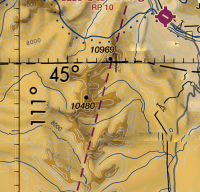
What is the center peak with an elevation listed on this map type that some of you may have never seen. Is that a good hint? :cool: If not, that purple icon signifies an airport with runway direction and other details.
Screen Shot 2017-08-26 at 11.51.19 AM.png
 
Last edited:
Looks a lot like Electric Peak and the Gardiner Airport.

Are you a pilot, Art?
Great job! The center peak is Humphrey's Peak. The 10969' peak is Electric but close enough. The map is called an FAA sectional. You are up, Liz.
I have been a pilot for many years but not currently licensed by the FAA. I can't afford the sport license airplane. :(

But I have piloted a variety of full size aircraft, owned an ultralight to fly and various radio-controlled airplanes, helicopters and semi-autonomous, gps-stabilized, flying camera platforms that some people insist on calling drones to denigrate them. :)
 
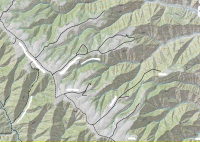
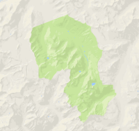
Speaking of flying, if you've ever flown over this place it will amaze you at the razor sharp ridges and deep canyons. It became world famous a decade or so ago. Some of you have been very close to it, and others may have actually had the privilege of being allowed into its inner reaches.

Screen Shot 2017-08-26 at 1.52.55 PM.png
 
Great job! The center peak is Humphrey's Peak. The 10969' peak is Electric but close enough. The map is called an FAA sectional. You are up, Liz.

Hey Art, just pointing out a minor error, the center peak is Joseph Peak. I'm guessing that you had a previous answer (Jackson's post from yesterday) stuck in your brain when you typed this.
 
I think I got it, Dennis.
Yessir, you did indeed. :)

Speaking of flying, if you've ever flown over this place it will amaze you at the razor sharp ridges and deep canyons. It became world famous a decade or so ago. Some of you have been very close to it, and others may have actually had the privilege of being allowed into its inner reaches.

View attachment 57376
Wow, strange. I'm going there today...leaving home in just under two hours. Gonna spend the night in the Jeep outside the area, then head in on foot at first light. I'll leave it for someone else to guess, since I'll be away from a computer for a couple of days.
 
I knew you would know where it is. Have fun and be sure to check out Locomotive Rock. Watch for lost Fremont flutes, too. :)

(A couple of good clues above.)
 
Last edited:
I just came back to make the "guess" but you beat me to it. I was gonna post something near Wendover, but I think you earned the right to post something, Art. :D
Nothing special... just lurking, following you two around....:moses:
 
Name this north american mountain range please. (side note - does anyone else see a figure in this range's outline?)

Screen Shot 2017-08-28 at 6.10.53 AM.png
 
I thought it might be fun to do a Guess the spot thread but instead of posting photos, you post a screen shot from a map. Terrain View, Satellite View or Topo View. Feel free to blur/erase any names if they give too much info.

The BCP maps page is great at getting topo layers, sat and terrain. Check it out here: http://backcountrypost.com/map/

I'll kick it off with this one. Name the prominent feature, not just the river.

View attachment 5041

I just found this. Great map program. Can you explain topo layers? Is that just a topo?
 
I just found this. Great map program. Can you explain topo layers? Is that just a topo?
I'm not tracking ya, Glaster....
A guess as to your question...? This view is the Google Maps Terrain View. It has been at risk over the years - Google keeps threatening to abandon it. Many of us love it for its view of topography - even zoomed way out you can see ranges and canyons easily whereas the typical topo map only works very close to the nape of the earth, i.e. zoomed in.
 

Don't like ads? Become a BCP Supporting Member and kiss them all goodbye. Click here for more info.

Back
Top