Escalante Canyons conditions update Sept. 12th

intuitive cat

Jurassic Dust in my Bones
Joined
Mar 9, 2012
Messages
402
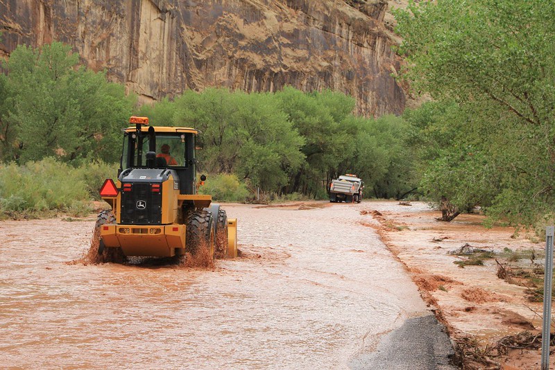
I just talked to a buddy of mine that works for the BLM over in Escalante and as it is right now, all Garfield County maintained roads are CLOSED. Hole In the Rock, Cottonwood, Skutumpah, Old Sheffield Road, Hell's Backbone, Smokey Mountain Road, etc. are all CLOSED and impassable until the county crews get out to repair flood damage.
The Circle Cliffs and Burr Trail areas did not get as much rain, but I have not heard if the Wolverine Loop Road is open or not yet, my guess is that it is NOT.
Even the Park Service and other federal agency people have not been able to get out yet to completely determine the damage.
I visited the Escalante River trailhead today to check conditions and it flooded the entire flood plain up to the parking area and also took out the bridge that crosses Calf Creek at the confluence.

Hope this info helps any of you that have been working on plans to come visit the area anytime soon.

I'll try to post updates as I find out more.
 
I should point out that we got around 5 inches within 3 days here in Boulder, UT. flooding everywhere, washes here crossing roads where no one had seen them do so before. We got a break in the rain today and it has been sunny and drying up a little bit but more rain expected over the next few days.
 
our water supply is definitely up over 100%!
it has been nuts. raining for days on end.
i'll upload a few pics when i get a chance.
sucks though, as I have a friend in town from Key West (luckily he is here for a month so we have time...) that is aching to get out and hike and now we have to rethink almost all of our plans in terms of accessibility. Going to have to mostly do hikes starting off of the Burr Trail or Highway 12. I'm kind of anxious to head along the river and see the state of things.


Capitol Reef!! Frying pan trail should be awesome when wet. @NateGeesaman shared a SPOT message at Cassidy Arch today. @Bob Palin also shared some crazy photo's of HWY24.


Utah 24 Flooded, 11 September 2013 (1) by Bob Palin, on Flickr
 
Dang, are you folks in a desert? We (MD) just got hammered by a nasty rain/hail storm tonight. Bike commute was a tad messy. 1st rain in 3 weeks. Could you send us a bit, please.
 
Capitol Reef!! Frying pan trail should be awesome when wet. @NateGeesaman shared a SPOT message at Cassidy Arch today. @Bob Palin also shared some crazy photo's of HWY24.

I passed Nate just south of Boulder heading in opposite directions earlier today when I was heading down to check out the river.
heading over to Capitol Reef is a great idea. I'm just waiting to see how the sky looks tomorrow....finally a day off of work to go play.
I take a full week off later in the month so we can do some more serious backcountry.
Hoping that by that time the roads will be fixed which will also mean a freshly graded Hole In the Rock Road!
 
I'm blaming @Miss Buffalo for all this flooding! ;) I remember her saying she attracts storms and she just moved to southern UT last year and now everywhere down south has been getting slammed! Coincidence? I think not! :p

Joking aside, I've been really wishing I was down there to enjoy the flooding with ya!!
 
And I'm happy we had all these storms. So I could get out between classes yesterday and capture some flash floods in Snow Canyon. :frantic:
And got cut off on my way back to my car which was unfortunately parked on the other side of the flooded wash :whistle:


i-vbFmwnv-L.jpg


i-Z9hg43L-L.jpg
 
I'm blaming @Miss Buffalo for all this flooding! ;) I remember her saying she attracts storms and she just moved to southern UT last year and now everywhere down south has been getting slammed! Coincidence? I think not! :p

Joking aside, I've been really wishing I was down there to enjoy the flooding with ya!!

I just ordered the storms for myself, I'm selfish.
With the storms going on I could play outside :D
 
@intuitive cat Thanks for the updates. Would appreciate hearing whatever progress is being made on road repairs. Meeting a group of folks in Escalante first week of October and I hope not to change too much because of road closures. Glad it's still 3 weeks away.
 
I spoke to an acquaintance briefly this week who works for the NPS in Capitol Reef. He says you had better not plan on heading into Cathedral Valley.
 
I almost came out to Utah mid September, glad I delayed until early Oct. Let's hope it clears by then. Crazy weather.
 
When I think of flash floods in southern Utah, Paria Canyon/Buckskin first comes to mind.

The average flow this time of year is 10 cu ft/sec., but I'm always thinking high potential for flash flood between mid July to the first week in October so average is irrelevant. With all the rain this week I checked the USGS water data for the Lee's Ferry Gaging Station.

OK, now follow me hereo_O 
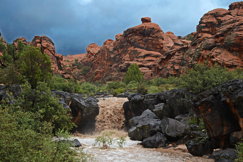
The flow is calculated using an algorithm based on the gauge height at that station. According to the posted data on Sept 11 at 19:15 the flow was 460 cu ft/sec, at 19:30 it was 2490 cu ft/sec , 19:45 4480 cu ft/sec , 20:30 6500 cu ft/sec.

From 20:45 - 21:30 the river continued to rise, but the algorithm the USGS is using caps out at gauge height of 11.30ft (equals 6600 cu ft/sec. ) The maximum gauge height was measured 12.66 ft. (see link below for USGS table). The data is provisional, but my guess is when they complete the final calculations the flow will have exceeded 9000 cu ft/sec. If so, this will have been the highest flow since 1958.

I already hiked Paria this past May, but thinking of taking another run at it in early - mid October to see how much the canyon has changed. Anyone interested in joining me?
USGS 09382000 PARIA RIVER AT LEES FERRY, AZ http://waterdata.usgs.gov/az/nwis/u...13-09-11&end_date=2013-09-11&site_no=09382000
 
Similar threads
Thread starter Title Forum Replies Date
W 9 Days Solo Escalante Loop in October (water advice) - Stevens Canyon, Baker Route over Waterpocket fold, Halls Narrows to Moody Canyons Trip Planning 11
swmalone Escalante Canyons National Park General Discussion 59
S Escalante Canyons with kids Canyoneering 2
Scott Chandler First Time to the Escalante Canyons, Part 2 Backpacking 5
Scott Chandler First Time to the Escalante Canyons, Part 1 Hiking & Camping 2
intuitive cat Escalante Canyons slideshow Photography 0
K Escalante Canyons, 10-person group, 5-days in June '12? Trip Planning 5
B Is there water at Colt Mesa tank - Escalante Trip Planning 6
desertvic The Grand Staircase Escalante NM needs you! Meet Up (Members Only) 1
TrailScot Hole-in-the-Rock Road - Escalante General Discussion 11
G Escalante area 4-5 night backpack trip suggestions in late September. Loop if possible. Limit technical sections if any. Thanks! Backpacking 6
canadug Escalante area exploring Trip Planning 0
TrailScot Escalante Loop via Dry Hollow and Boulder Mail Trail - September 2023 Backpacking 8
Kullaberg63 Suggestions for Escalante east of river, south of Choprock Trip Planning 4
fossana A challenging week on the Escalante Overland Route Backpacking 21
fossana Public comment for revised Grand Staircase Escalante NM management plan (comments open 11 Aug - 9 Nov) General Discussion 11
BJett Part 3 - Tour de Canyon Country. Lower Escalante Loop Hiking & Camping 0
radioradio Sad Cowboy Traverse - A Week in Escalante Backpacking 12
F Upper Escalante River Backpack conditions Trip Planning 6
radioradio Anxious About Escalante Trip Planning 64
regehr Escalante dumpsters Trip Planning 9
regehr potable water in Escalante town? Trip Planning 6
D Fox Canyon Escalante? General Discussion 7
Janice Water questions - Escalante area Trip Planning 38
Duketogo13 BMT- Death Hollow-Escalante Triangle loop Trip Planning 20
Janice Cosmic Ashtray via Wolverine/Little Death Hollow & Escalante River? Trip Planning 16
Duketogo13 Questions about packrafting the Escalante/Lake Powell in September. Need help! Trip Planning 5
priz1234 The Gulch Escalante 4/17-4/18 Backpacking 2
RyanP Conditions (water/bugs) for Escalante/Death Hollow Trip Planning 27
J Escalante Natl. Mon. to Bryce N.P. the (unknown) Final Dayhikes April 15-16, 2021 Hiking & Camping 9
Bob Lost in the Escalante .......... Blast from the Past Backpacking 6
Bob A short Escalante trip end of April Backpacking 5
swmalone Restaurant Suggestions for Escalante or Boulder General Discussion 11
S Packrafting Escalante - FiftyMile Creek and low water level Lake Powell Trip Planning 8
swmalone Camping suggestions for Escalante in May Trip Planning 2
Muddy Waters Stevens, Fold, Escalante River, Fools, Kings Mesa Trip Reports 3
T Status of Traffic - Hole in the rock road - Escalante - September? Trip Planning 2
ramblinman Boulder Creek Day Hike, Escalante National Monument Hiking & Camping 5
M Ideas for 4 nights in Escalante Trip Planning 30
M Non-technical 1-2 night backpacking w dogs and kids - Escalante-ish area in April? Trip Planning 14
A 1st time backpacker in Escalante, UT Trip Planning 13
Stephanie B Grand Staircase Escalante National Monument - Kanab Area Hiking & Camping 2
Titans Permits car camping Grand Staircase Escalante NM? Trip Planning 6
Devin Ashby The Lower Gulch - Escalante (Seeking info on the route) Trip Planning 14
R Escalante River / Calf Creek Falls Current Conditions Trip Planning 10
cmgz Boulder Mail Trail - Escalante Trailhead to Mamie Creek Hiking & Camping 1
W Escalante River Backpacking Trip Planning 12
ADubs Looking for info from anyone who has done the Egypt loop and exited via 25mile wash (Escalante). Trip Planning 3
swmalone Rain, Mud, and Wind....First Trip to Escalante Area Hiking & Camping 16
canadug Current Escalante and Cap Reef Road conditons Trip Planning 17

Similar threads

Back
Top