Navigation
Install the app
How to install the app on iOS
Follow along with the video below to see how to install our site as a web app on your home screen.
Note: This feature may not be available in some browsers.
More options
Style variation
You are using an out of date browser. It may not display this or other websites correctly.
You should upgrade or use an alternative browser.
You should upgrade or use an alternative browser.
Escalante Canyons conditions update Sept. 12th
- Thread starter intuitive cat
- Start date
powderglut
In search of Fresh
- Joined
- Oct 17, 2012
- Messages
- 367
Totally liking that!Melissa will probably report more details, but she got all the way to the end of Hole in the Rock Rd in A 4X4 yesterday.
neiloro
Member
- Joined
- Jan 19, 2012
- Messages
- 104
Melissa reports that it was no trouble at all to get to the end of HITRR in a 4wd. They had to slow down sometimes, but otherwise good. Many of the side roads may not be passable. They could not get far on Cedar Wash Rd. Getting to Devil's Garden was fine. Getting to the Peekaboo trailhead was fine with high clearance, but somehow an RV made it there. That is all.
powderglut
In search of Fresh
- Joined
- Oct 17, 2012
- Messages
- 367
Thanks for passing this on. I'll be in Escalante late afternoon next Wednesday. Hoping the weather holds.Melissa reports that it was no trouble at all to get to the end of HITRR in a 4wd. They had to slow down sometimes, but otherwise good. Many of the side roads may not be passable. They could not get far on Cedar Wash Rd. Getting to Devil's Garden was fine. Getting to the Peekaboo trailhead was fine with high clearance, but somehow an RV made it there. That is all.
intuitive cat
Jurassic Dust in my Bones
- Joined
- Mar 9, 2012
- Messages
- 402
love hearing this.... tempted to go hit Willow or one of the other canyons towards the end of the road next week.
I'll hopefully be seeing my BLM buddy and getting more of his 'official' info soon.
I did go out Lampstand Road on the north end of the Circle Cliffs recently and the washes were a mess compared to 'normal' but not bad.
The bigger pain was dealing with multiple 6 to 10 inch deep and wide small run channels across the road that would sneak up on me.
I took my International Scout out there, probably would not have taken my AMC Eagle past a few of the washes just due to deeper sand and a bit of leftover mud with some wonky wash crossing angles (would not recommend an Outback or similar due to clearance issues).
wash crossing rises averaging about 2 to 3 foot tall.
Horse Canyon part of the Wolverine Loop is still a mess and the road into the Silver Falls trailhead is washed out 2 miles out.
Lower half of Moody Road is impassable with fallen boulders , lots of debris and washed out ledging and may not be passable for a long long time as it will be way down the priority list of roadwork.
John Kerby
Member
- Joined
- Feb 18, 2013
- Messages
- 85
In Utah? The general region?
intuitive cat
Jurassic Dust in my Bones
- Joined
- Mar 9, 2012
- Messages
- 402
In Utah? The general region?
Not sure exactly what your questions are in reference to specifically, but I started this thread in reference to Garfield County Utah and the Escalante Canyons region. I am not sure what backroad conditions are like elsewhere in Southern Utah, but I know that the majority of the impact from the storms a few weeks ago was from Capitol Reef west to the Cedar City area. The center of most of the local storm cells moved from the Page/Kanab area up through the Paria River system & Bryce Valley - north up the Paunsaugunt and Markagunt plateaus (the plateaus on either side of Highway 89 through Southern Utah).
Here in Boulder, Utah, we received 6.5" (4" of it within 2 days) of rain within a week and a half and we were mostly on the eastern edges of the storm cells.
There are very limited funds, equipment and workforce to do the road repairs (remember that we are talking about a county that only has 5,000 residents and a very limited tourist industry compared to places like Grand County or the Zion area), so it is taking quite a bit of time and they are concentrating on main roads first (such as Hole in The Rock Road).
intuitive cat
Jurassic Dust in my Bones
- Joined
- Mar 9, 2012
- Messages
- 402
this isn't a road update, but worth mentioning...
The Escalante River trail between Death Hollow and Sand Creek is currently nightmarish.
Most of the previously existing trail is gone, buried under sand, as there are huge sand deposits everywhere. Add to it that there are currently (as of Oct. 1, 2013) 2 Russian Olive removal crews in that area doing massive cutting.
Cutting debris has made many areas serious bushwacks or nearly impassable due to debris flow buildup with the floods. there are walls of wood all over and all of the underbrush that is smaller than sagebrush is all buried in sand. We saw 50 foot tall cottonwoods that had been nocked down, newly formed washes on high ground that are 50 feet wide and 3 to 5 feet deep.
I hardly even took any pictures in this section because i was concentrating so much on simply trying to find a route and manage a path through all of the tamerisk and other debris as well as attempting to find river crossings that had manageable banks.
upstream and downstream of the area are ok...downstream more affected, of course. the broad area next to the Natural Bridge is even nothing but a big sand plain now.
most of the trail is marked by small red ribbons on bushes and trees.
It is going to be awhile before anything on the river along that stretch begins to look anything close to healthy and normal again.
powderglut
In search of Fresh
- Joined
- Oct 17, 2012
- Messages
- 367
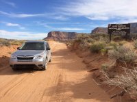
Interesting. I was just there, and the ranger at the beginning of the road was telling everyone that mile marker 47 was the limit, and that a Glen Canyon ranger was there with a road block. Not the case? They just throwing us a curve? They also had signs that Coyote Gulch was closed because it is mostly all in the Glen Can NRA.Drove the Hole-in-the-Rock to the end two days ago... I'd say its HC 2WD all the way.
- Joined
- Apr 22, 2013
- Messages
- 320
powderglut
In search of Fresh
- Joined
- Oct 17, 2012
- Messages
- 367
They were there on Sunday. Maybe they had better things to do, like keep people off the lake somewhere else.. Glad to see you got out there. I thought they had the road in pretty decent shape considering. The wash at Left Hand Collet rd was amazing, with huge trees and debris all stacked up on the sides. Egypt road is in pretty great shape too. As well as Old Sheffield.There was no Ranger on Monday... hard to imagine they would throw a road block up on a week day... but that's just me.
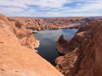
Here's a picture of me easily passing through the Escalante to the Glen Canyon boarder")
baltocharlie
Member
- Joined
- Dec 21, 2012
- Messages
- 324
Maybe they are patrolling on the weekends only.
powderglut
In search of Fresh
- Joined
- Oct 17, 2012
- Messages
- 367
They were there (HITR Rd) from Wed thru Sunday. Apparently not on Monday. Probably needed help in the "war zone" keeping people out of the Wave.Maybe they are patrolling on the weekends only.
baltocharlie
Member
- Joined
- Dec 21, 2012
- Messages
- 324
war zone
")
intuitive cat
Jurassic Dust in my Bones
- Joined
- Mar 9, 2012
- Messages
- 402
Well, remember that it is GSENM and there simply aren't many rangers,not like in a park, really only one or two, so they are spread thin.
the one I know works the Escalante Canyons section the most has been spending a lot of time monitoring Lower Calf Creek Falls, as there have been a lot of people parking outside of the closed gates and hiking in and they want to make sure no one is camping there (which is weird considering it is wide open without an attendant in the off season).
I've also heard that he is randomly patrolling Coyote Gulch.
I would imagine that they are mostly watching the highest use areas.
During the National Park closures, we've actually seen an influx of more people in our area since the hiking is more open and easily accessible.
I drove by the Escalante River trailhead on HWY 12 the other day and there were about 6 or 7 overflow cars on the highway because the parking lot was full.
intuitive cat
Jurassic Dust in my Bones
- Joined
- Mar 9, 2012
- Messages
- 402
Just had a conversation with a guy that works for the Garfield County Roads department and was informed that they took graders through the Circle Cliffs area and Burr Trail/Notom/Sandy Ranch this last week, so Lampstand and the Wolverine Loop Road etc. have now been graded and repaired.
Yvonne
I lava it!!!
- Joined
- Jan 19, 2012
- Messages
- 4,180
no ranger patrolling Thursday to Sunday. We only went down to Forty Mile Ridge. The entire parking lot was deserted. Harris Wash TH was basically empty and many other areas but Dry Forks were packed with crowds.
Most roads were in good conditions, Hole in the Rock Road down to Dance Hall Rock was great and most damage repaired. A few rougher spots but absolutely doable with any HC vehicle.
Also Harris Wash Road, Forty Mile Ridge,Egypt Road, Spencer Flat.
Most roads were in good conditions, Hole in the Rock Road down to Dance Hall Rock was great and most damage repaired. A few rougher spots but absolutely doable with any HC vehicle.
Also Harris Wash Road, Forty Mile Ridge,Egypt Road, Spencer Flat.