- Joined
- Dec 23, 2013
- Messages
- 4,124
The Beartooth Wilderness has been on my bucket list for years now, but I could never seem to fit it into my backpacking schedule. This past fall, I made a commitment that I would check it off of my list this summer.
My route was to begin at the Island Lake Trailhead, which is located just off of the Beartooth Highway, about 27 miles ( I think) east of Cooke City. I conceived a six day lollipop loop trip that would take me up into the alpine country and spit me back out at the same trailhead without hopefully seeing too much of the same scenery on my way back to the trailhead.
On rather short notice, I extended an invitation to @Bob to join me, and he graciously accepted. He had one caveat though, he needed to be out of the backcountry one day earlier than me due to commitments back home. So we decided to meet at the Beartooth Lake Trailhead, drop his vehicle off, and then proceed on to the Island Lake Trailhead where we would begin our trip.
When planning, I tried to break up the route into segments that I thought I could get done in a day of mostly off-trail hiking. When I sent the route to Bob, he had a few suggestions on lakes that he thought might have better views/fishing opportunities, so we ended up splitting the days into around six mile days between our campsites.
As many of you probably know, the Beartooths lend themselves to what I will call "lake hopping" across the plateau, so this is exactly what we did.
Our typical day would consist of getting up when the sun hit our tents, this could be anywhere between 7:30 in the morning up to 8:15 am. Of course, we would then have some breakfast, pack up our gear, and then head out towards our next campsite. Our backpacking time between campsites ran into the six and a half hours to up over eight hours on some days. It just depended on the terrain we encountered, lunch breaks, stopping to catch a good view, and Bob enjoyed fishing at some of the lakes we passed along our route.
The wildflowers along our entire route were tremendous. It had to be the perfect time of year this year for them. The mosquitoes on the other hand were relentless. My shoulders and back were just covered with bites. I guess that is the price one pays in order to see the flowers at their peak.
Here is our story:

Overview map of our route. Bob's early exit to the Beartooth Lake trailhead is show in red.
Day 1 - Island Lake Trailhead to Albino Lake

Day 1 overview map
There is a campground next to the Island Lake Trailhead, so the Island Lake area is a fairly popular place for folks to recreate at this time of year. That would probably explain the number of people that we encountered on our first day going in. We saw people who were fishing and boating on Island Lake, more people fishing on Night Lake, and we encountered day hikers along the trail who had headed up to Becker Lake, and even on to Albino Lake to fish for the day.
There is an official trail that takes you maybe 1.5 miles past Night Lake, then a social trail north to Becker Lake and then on to Albino. This made the first day rather straight forward and relatively easy for us. As we approached Becker Lake, we began to get into the upper alpine environment that the Beartooths are known for.
As we reached Albino Lake that evening, there was a group of maybe twenty people (part of a youth group we learned later) that were leaving the lake, but that still left quite a few who were hanging around the south end of Albino. We headed to the far northwest side of the lake to have some solitude for the night.
After turning in for the night, I heard something trotting along by my tent, and then another trot, trot, trot. At first I thought it might be deer heading down to the lake for some water, but after continuing to hear this trotting next to my tent, I decided to investigate what was making the noise. When I opened up the fly to my tent, there was a mountain goat staring me in the face, and she had a little one in tow. I said, "Hey buddy", which made the little one take off, but the adult only took a couple of steps back. Soon the little one returned to her side. While this was fun to watch, I began to wonder if a mountain goat would chew on our gear? Did it want to nibble on a backpack strap? Or my boots? I wasn't sure, but it worried me a bit. Well, this went on for a good portion of the night, but I still managed to get some sleep.

Bob, checking out the info sign at the Island Lake Trailhead

A look north towards Lonesome Mountain as we head towards Becker Lake

Moving on towards Albino Lake, with Becker Lake to the south

Arriving at Albino Lake - our home for the night

The northwest corner of the lake where we would make camp for the night

Bob taking in the view and the aplenglow. Where Bob is sitting became a favorite place for the mountain goats later that night.

My tent at our first campsite.
Day 2 - Albino Lake to Flat Rock Lake

Day 2 overview map
Heading to Flat Rock Lake today. The social trail that brought us to Albino Lake will continue onto the first part of Jasper Lake, but then we will be off trail for the next couple of days. This day was probably the toughest for me, probably due to the first off-trail portion, plus my pack was still a bit heavy.
I learned quickly that the beginning of each day would require a steep hike up and out of a lake basin in order to get to the next lake. Smart aren't I?")
When we reached Jasper, Bob took out his rod and fished for awhile along the western shore. To me, it looked like he was getting a catch with almost every cast.
As we left Jasper and began off-trailing it, we started to have to make a decision when we reached the next lake or pond on our route, and that was which way to take around the lake. Sometimes the choice was easy, sometimes not so much. I guess it added to the adventure.
After Jasper, we passed by Triskele, Donelson, and Maryott Lakes, before dropping down towards Crystal Lake. This is where I realized that Bob is half mountain goat! He was going down those rocks like a hot knife through butter.
We didn't actually reach Crystal Lake though as once we dropped, we contoured around and up the Sierra Creek Drainage towards Flat Rock Lake instead.
They last little climb to Flat Rock was tiring to me, but it was worth the view once we reached the lake.
On our second night, Bob had the mountain goats at his tent, as they grazed within a foot of his head. He had his tent fly open for the night, and he was able to watch three goats. Pretty cool.

The first saddle that we had to deal with today. Hiking out of the Albino Lake Basin

Jasper Lake below. We are about to lose the social trail at this point.

A peak down at the northeast end of Golden Lake, which we would visit later on our route

Ahead is the next pass we have to go over on our way to Triskele

Working our way up the pass

View to the north from the saddle

View to the northwest from the top of the saddle

Triskele Lake

More high alpine views

Bob, taking it all in

Donelson Lake

Which side is easiest?

Dropping down towards Crystal, though we would never reach it.

Sierra Creek down below

Contouring around the mountain as we make our way up the drainage

A lot of cascading waterfalls on this trip Fallls on Sierra Creek

The Flat Rock Lake Basin ahead

One more waterfall to go

Our campsite at Flat Rock Lake
Day 3 - Flat Rock Lake to Jorden Lake

Day 3 map overview
We began the day with a steep climb out of the Flat Rock Lake Basin and up towards Copepod Lake. Originally, our route would take us past Cladocera Lake and up over the pass to the northwest of the lake, then down along a string of unnamed lakes to Big Butte Lake, but we decided to cut up and over south of Copepod Lake, then down towards Erratic Lake. Again, we didn't actually reach Erratic Lake, as we contoured over to Robble Lake, then on west and down to Big Butte Lake.
Views from the high alpine along our new route were spectacular, and we stopped and had lunch on a peak I named "Bob's Peak."
Once we reached Big Butte, we made our way south to Jorden Lake where we set up camp on the north end of the lake. The route down from Widowed Lake to Jorden was a steep descent.
This third day was another tiring one for me, not as bad as day two, probably because the I got more sleep due to the goats bothering Bob instead of me. Unfortunately, we wouldn't see another goat for the rest of our trip. Also, we got a bit of rain for the first time on our trip this day.

A new morning on Flat Rock Lake. A look up at the pass we will have to cross over

The wildflowers were so beautiful on this trip. Monkeyflower, paintbrush and groundsel on the way up to the pass

Another cascade we followed up the pass

Still a little more to go

Copepod Lake

High country views - Castle Rock Mountain

Snowfields were plentiful cutting across towards Erratic Lake

Bob, perched on his namesake peak - unnamed lake below

A look back north at Bob's Peak

A look to the southwest

Bluebells and paintbrush

Erratic Lake below

Coming up on Robble Lake

Another cascade to climb

Till Lake - again which side looks the quickest? Good question. We chose the southern shore.

Gravel Lake

Big Butte Lake below with a lot of rock hopping on the descent to the lake. Desolation Lake can be seen in the distance and was
part of our original route.

A group of yellow columbine on our way down to Big Butte

Dropping to Anchor Lake

Widowed Lake

Steep descent to Jorden Lake

Jorden Lake, viewed from our campsite
Day 4 - Jorden Lake to Cloverleaf Lakes

Day 4 overview map
On this day we go to see some short sections of trail before heading off-trail again. There was a trail out of Jorden Lake, but unfortunately it went straight up the mountainside, and was a little bit hard to follow at times. So much for making good time.
Once at the top of the hill, we left the trail and headed down a nice meadowed canyon towards Lake Elaine. There was some slight bushwhacking through willows and forest along this stretch as we neared Lake Elaine.
When we reached Elaine, we ran into a group of four backpackers who we had seen out ahead of us before, on our drop down towards Crystal Lake a couple of days ago. They ended up camping at Crystal Lake that night before moving on to Elaine. These gentlemen were all from Wyoming and had backpacked in the Wind Rivers, one of them also in the Bighorns previously. One of them was kind enough to take a shot of Bob and myself before they headed out towards Granite Lake.
After Crystal, we picked up a social trail to Green Lake, where Bob found a single flip-flop (they still call them that don't they?) which he would put to good use on a coupe of wide creek fords that were ahead - the first of which was the outlet of Green Lake.
On the east side of Green, we picked up a trail that again went straight up the hill! Please! At the top of the hill, we passed by Trail Lake before dropping down to Wright Lake. At Wright, it was again off-trail to Martin Lake where we chatted with a couple of people camped at the Lake.
Once we left Martin, it was a steep climb up to Rachel Lake, and then onto Cloverleaf Lakes for the night.
As we were rock hopping along the south side of the western most Cloverleaf Lake, the sky cut loose and we had to set up camp in the pouring rain. During the storm the temperature dropped to 52, which I believe was the coldest temp on our trip.
Back in the rocks again to camp, we thought we might get some mountain goat visitors again, but it wasn't to be.

Hiking up and out from the Jorden Lake Basin on a trail. Can you see the trail? Yeah, neither can I.

Heading back off-trail now as we drop into the canyon and head towards Lake Elaine

Meadow hiking towards Lake Elaine

Group shot at the Lake. That's an external frame pack in the lower left hand corner. Old School!

Green Lake

Bob, contemplating using his single flip-flop at the outlet of Green Lake

The trail from hell. Viewed from our lunch break location. I'm going to need some
calories for this one.

It's a good thing that Bob let me eat my lunch before tackling this hill, because if he hadn't this would have occurred about a quarter
of the way up instead of almost at the top. This horse trail is the curse of Dooley @Rockskipper, the curse of Dooley I tell you.

Trail Lake

Wright Lake

Martin Lake - the steep pass to Rachel dead ahead.

Approaching the rocky climb.

Egads! Help!

Rachel Lake

Fringed Grass of Parnassus - sounds fancy, at Rachel Lake

More climbing ahead

Just gorgeous

Didn't we just go up a fall?

Cloverleaf Lakes (the western lake). We are headed to the other side of the lake and all hell broke loose as we made our way along
the rocks you see in the shot along the south end of the lake. Bob said that he never saw me move so fast.

Campsite at Cloverleaf Lakes after the deluge

Bob catches another cutthroat

Ground squirrel at camp who we will see more of on day 5

View to the west towards the outlet, in the evening through the storm clouds
Day 5 - Cloverleaf Lakes to Night Lake for me, to the Beartooth Lake Trailhead for Bob

Day 5 overview map
Today's route takes us up and over to Golden Lake which we had looked down on on day two. The outlet of Golden was a bit tricky (thought me might be cliffed out), but we managed a rocky/boulder descent to an absolutely gorgeous meadow and stream below.
Before reaching Hidden Lake, we had to take a left, ford the outlet stream of Golden Lake and then head up a pass to the east in order to drop down to T-Lake.
Just after T-Lake, we picked up the official trail, and it was trail hiking the rest of the way out for both of us.
Soon, we reached the junction for Bob to head up and over the ridge and then drop down to Beartooth Creek and head back to his vehicle at the trailhead. We said our goodbyes and I headed east towards Beauty Lake and on to Night Lake for my last night in the backcountry.
When I reached the Beauty Lake Trail Junction, I took a few minutes and ate some lunch. While eating a man comes down the trail that leads to Becker Lake with his cell phone in his hand and a one-eyed dog. He stops and starts asking me all kinds of questions. Questions like, "If I go up this trail what lakes can I see?" I told him that Beauty Lake was just through the trees if he wanted to see a lake. He responded that he thought he'd head to Becker Lake. I said, "You just came down the trail that leads to Becker." "Oh," he said. He then told me he had his pack in the car and was thinking about backpacking to up above tree line. I said, "That sounds like fun" He then went down the trail towards Beauty Lake. Not five minutes later he is back at the junction, and says, " I need to get far away from roads," and then he heads up the trail towards T-Lake. First, there is no road at Beauty Lake, and I thought to myself I just might be reading about this guy in the papers (old school) or on the internet for you younger folk.
After he left, I continued on to Night Lake and found a place to set up camp, eat some dinner and call it a day.

Morning on Cloverleaf Lakes. Blue sky!

Baby ground squirrels. The had a burrow near out tent sites

Momma is back

She began carrying the young ones to a different burrow further away from us

Approaching the eastern most Cloverleaf Lakes

Heading up and over to Golden Lake

Unnamed Peak along the way

Another unnamed peak

View from the pass

Looking down on Golden Lake with Lonesome Mountain back again

The outlet at Golden Lake. It looks like it might be unpassable, but we found a grassy ledge that went up and through the cliff band

More boulder hopping to be done to drop down to the meadow

A look back up towards the outlet of Golden Lake

The meadow below

A quick break with a wonderful view ahead

Ready to ford the outlet stream of Golden Lake

Bob, fording the outlet stream

View to the west as we begin to climb up to the pass

Our last pass of the trip

Northern end of Hidden Lake below

Lonesome Lake and to the north below along with Lonesome Mountain

T-Lake ahead

Lonesome Mountain

Bob, making his way up and over the ridge towards Beartooth Creek

Some mushrooms along the trail

Unnamed lake ahead

Beartooth Plateau in the distance

Official trail

Beauty Lake

Junction signpost

Night Lake

Last night's tent site on Night Lake

A mushroom near camp

And another one
Day 6 - Night Lake to the Island Lake Trailhead

Day 6 overview map
A quick and easy hike out on day six. It was short enough that I didn't need my knee brace for this one.

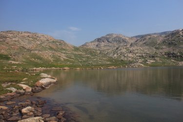
A look back at Island Lake and the Beartooth Plateau

Back at the info sign

Arriving at the Subaru at the trailhead.
Well, what a trip! Bob clocked in at 33 miles and I eked out an extra mile at 34. I really feel like you need to add about ten percent to these distance totals though to get the true mileage of our trip. While Bob hikes in a straight line, I know I'm at a constant zigzag so maybe I did 45 miles.
While the scenery and wildflowers were worth the price of admission alone, other than the mountain goats, we didn't see any other big game wildlife the entire time. Even signs of them like scat and tracks were minimal - zero sign of bear. That kind of surprised me to a certain extent.
The warm nights caught me off guard too. I was expecting in the 40's, but got high 50's and low 60's instead.
Still, well worth the time to see the wilderness if you have never been before in my opinion.
I'm hoping that Bob will chime in with some of his thoughts on the trip. He can also address any fishing questions as to which were the best lakes to fish at, what type of lure to use, and how to hold your mouth just right in order to reel in the really big one. Also, he may have some images that add to the feel of our route, so hopefully he will share a few. Thanks Bob, I enjoyed it.
The End
My route was to begin at the Island Lake Trailhead, which is located just off of the Beartooth Highway, about 27 miles ( I think) east of Cooke City. I conceived a six day lollipop loop trip that would take me up into the alpine country and spit me back out at the same trailhead without hopefully seeing too much of the same scenery on my way back to the trailhead.
On rather short notice, I extended an invitation to @Bob to join me, and he graciously accepted. He had one caveat though, he needed to be out of the backcountry one day earlier than me due to commitments back home. So we decided to meet at the Beartooth Lake Trailhead, drop his vehicle off, and then proceed on to the Island Lake Trailhead where we would begin our trip.
When planning, I tried to break up the route into segments that I thought I could get done in a day of mostly off-trail hiking. When I sent the route to Bob, he had a few suggestions on lakes that he thought might have better views/fishing opportunities, so we ended up splitting the days into around six mile days between our campsites.
As many of you probably know, the Beartooths lend themselves to what I will call "lake hopping" across the plateau, so this is exactly what we did.
Our typical day would consist of getting up when the sun hit our tents, this could be anywhere between 7:30 in the morning up to 8:15 am. Of course, we would then have some breakfast, pack up our gear, and then head out towards our next campsite. Our backpacking time between campsites ran into the six and a half hours to up over eight hours on some days. It just depended on the terrain we encountered, lunch breaks, stopping to catch a good view, and Bob enjoyed fishing at some of the lakes we passed along our route.
The wildflowers along our entire route were tremendous. It had to be the perfect time of year this year for them. The mosquitoes on the other hand were relentless. My shoulders and back were just covered with bites. I guess that is the price one pays in order to see the flowers at their peak.
Here is our story:
Overview map of our route. Bob's early exit to the Beartooth Lake trailhead is show in red.
Day 1 - Island Lake Trailhead to Albino Lake
Day 1 overview map
There is a campground next to the Island Lake Trailhead, so the Island Lake area is a fairly popular place for folks to recreate at this time of year. That would probably explain the number of people that we encountered on our first day going in. We saw people who were fishing and boating on Island Lake, more people fishing on Night Lake, and we encountered day hikers along the trail who had headed up to Becker Lake, and even on to Albino Lake to fish for the day.
There is an official trail that takes you maybe 1.5 miles past Night Lake, then a social trail north to Becker Lake and then on to Albino. This made the first day rather straight forward and relatively easy for us. As we approached Becker Lake, we began to get into the upper alpine environment that the Beartooths are known for.
As we reached Albino Lake that evening, there was a group of maybe twenty people (part of a youth group we learned later) that were leaving the lake, but that still left quite a few who were hanging around the south end of Albino. We headed to the far northwest side of the lake to have some solitude for the night.
After turning in for the night, I heard something trotting along by my tent, and then another trot, trot, trot. At first I thought it might be deer heading down to the lake for some water, but after continuing to hear this trotting next to my tent, I decided to investigate what was making the noise. When I opened up the fly to my tent, there was a mountain goat staring me in the face, and she had a little one in tow. I said, "Hey buddy", which made the little one take off, but the adult only took a couple of steps back. Soon the little one returned to her side. While this was fun to watch, I began to wonder if a mountain goat would chew on our gear? Did it want to nibble on a backpack strap? Or my boots? I wasn't sure, but it worried me a bit. Well, this went on for a good portion of the night, but I still managed to get some sleep.
Bob, checking out the info sign at the Island Lake Trailhead
A look north towards Lonesome Mountain as we head towards Becker Lake
Moving on towards Albino Lake, with Becker Lake to the south
Arriving at Albino Lake - our home for the night
The northwest corner of the lake where we would make camp for the night
Bob taking in the view and the aplenglow. Where Bob is sitting became a favorite place for the mountain goats later that night.
My tent at our first campsite.
Day 2 - Albino Lake to Flat Rock Lake
Day 2 overview map
Heading to Flat Rock Lake today. The social trail that brought us to Albino Lake will continue onto the first part of Jasper Lake, but then we will be off trail for the next couple of days. This day was probably the toughest for me, probably due to the first off-trail portion, plus my pack was still a bit heavy.
I learned quickly that the beginning of each day would require a steep hike up and out of a lake basin in order to get to the next lake. Smart aren't I?
When we reached Jasper, Bob took out his rod and fished for awhile along the western shore. To me, it looked like he was getting a catch with almost every cast.
As we left Jasper and began off-trailing it, we started to have to make a decision when we reached the next lake or pond on our route, and that was which way to take around the lake. Sometimes the choice was easy, sometimes not so much. I guess it added to the adventure.
After Jasper, we passed by Triskele, Donelson, and Maryott Lakes, before dropping down towards Crystal Lake. This is where I realized that Bob is half mountain goat!
He was going down those rocks like a hot knife through butter. We didn't actually reach Crystal Lake though as once we dropped, we contoured around and up the Sierra Creek Drainage towards Flat Rock Lake instead.
They last little climb to Flat Rock was tiring to me, but it was worth the view once we reached the lake.
On our second night, Bob had the mountain goats at his tent, as they grazed within a foot of his head. He had his tent fly open for the night, and he was able to watch three goats. Pretty cool.
The first saddle that we had to deal with today. Hiking out of the Albino Lake Basin
Jasper Lake below. We are about to lose the social trail at this point.
A peak down at the northeast end of Golden Lake, which we would visit later on our route
Ahead is the next pass we have to go over on our way to Triskele
Working our way up the pass
View to the north from the saddle
View to the northwest from the top of the saddle
Triskele Lake
More high alpine views
Bob, taking it all in
Donelson Lake
Which side is easiest?
Dropping down towards Crystal, though we would never reach it.
Sierra Creek down below
Contouring around the mountain as we make our way up the drainage
A lot of cascading waterfalls on this trip
Fallls on Sierra CreekThe Flat Rock Lake Basin ahead
One more waterfall to go
Our campsite at Flat Rock Lake
Day 3 - Flat Rock Lake to Jorden Lake
Day 3 map overview
We began the day with a steep climb out of the Flat Rock Lake Basin and up towards Copepod Lake. Originally, our route would take us past Cladocera Lake and up over the pass to the northwest of the lake, then down along a string of unnamed lakes to Big Butte Lake, but we decided to cut up and over south of Copepod Lake, then down towards Erratic Lake. Again, we didn't actually reach Erratic Lake, as we contoured over to Robble Lake, then on west and down to Big Butte Lake.
Views from the high alpine along our new route were spectacular, and we stopped and had lunch on a peak I named "Bob's Peak."
Once we reached Big Butte, we made our way south to Jorden Lake where we set up camp on the north end of the lake. The route down from Widowed Lake to Jorden was a steep descent.
This third day was another tiring one for me, not as bad as day two, probably because the I got more sleep due to the goats bothering Bob instead of me.
Unfortunately, we wouldn't see another goat for the rest of our trip. Also, we got a bit of rain for the first time on our trip this day.A new morning on Flat Rock Lake. A look up at the pass we will have to cross over
The wildflowers were so beautiful on this trip. Monkeyflower, paintbrush and groundsel on the way up to the pass
Another cascade we followed up the pass
Still a little more to go
Copepod Lake
High country views - Castle Rock Mountain
Snowfields were plentiful cutting across towards Erratic Lake
Bob, perched on his namesake peak - unnamed lake below
A look back north at Bob's Peak
A look to the southwest
Bluebells and paintbrush
Erratic Lake below
Coming up on Robble Lake
Another cascade to climb
Till Lake - again which side looks the quickest? Good question. We chose the southern shore.
Gravel Lake
Big Butte Lake below with a lot of rock hopping on the descent to the lake. Desolation Lake can be seen in the distance and was
part of our original route.
A group of yellow columbine on our way down to Big Butte
Dropping to Anchor Lake
Widowed Lake
Steep descent to Jorden Lake
Jorden Lake, viewed from our campsite
Day 4 - Jorden Lake to Cloverleaf Lakes
Day 4 overview map
On this day we go to see some short sections of trail before heading off-trail again. There was a trail out of Jorden Lake, but unfortunately it went straight up the mountainside, and was a little bit hard to follow at times. So much for making good time.
Once at the top of the hill, we left the trail and headed down a nice meadowed canyon towards Lake Elaine. There was some slight bushwhacking through willows and forest along this stretch as we neared Lake Elaine.
When we reached Elaine, we ran into a group of four backpackers who we had seen out ahead of us before, on our drop down towards Crystal Lake a couple of days ago. They ended up camping at Crystal Lake that night before moving on to Elaine. These gentlemen were all from Wyoming and had backpacked in the Wind Rivers, one of them also in the Bighorns previously. One of them was kind enough to take a shot of Bob and myself before they headed out towards Granite Lake.
After Crystal, we picked up a social trail to Green Lake, where Bob found a single flip-flop (they still call them that don't they?
) which he would put to good use on a coupe of wide creek fords that were ahead - the first of which was the outlet of Green Lake.On the east side of Green, we picked up a trail that again went straight up the hill! Please! At the top of the hill, we passed by Trail Lake before dropping down to Wright Lake. At Wright, it was again off-trail to Martin Lake where we chatted with a couple of people camped at the Lake.
Once we left Martin, it was a steep climb up to Rachel Lake, and then onto Cloverleaf Lakes for the night.
As we were rock hopping along the south side of the western most Cloverleaf Lake, the sky cut loose and we had to set up camp in the pouring rain.
During the storm the temperature dropped to 52, which I believe was the coldest temp on our trip.Back in the rocks again to camp, we thought we might get some mountain goat visitors again, but it wasn't to be.
Hiking up and out from the Jorden Lake Basin on a trail. Can you see the trail? Yeah, neither can I.
Heading back off-trail now as we drop into the canyon and head towards Lake Elaine
Meadow hiking towards Lake Elaine
Group shot at the Lake. That's an external frame pack in the lower left hand corner. Old School!
Green Lake
Bob, contemplating using his single flip-flop at the outlet of Green Lake
The trail from hell. Viewed from our lunch break location. I'm going to need some
calories for this one.
It's a good thing that Bob let me eat my lunch before tackling this hill, because if he hadn't this would have occurred about a quarter
of the way up instead of almost at the top.
This horse trail is the curse of Dooley @Rockskipper, the curse of Dooley I tell you.Trail Lake
Wright Lake
Martin Lake - the steep pass to Rachel dead ahead.
Approaching the rocky climb.
Egads! Help!
Rachel Lake
Fringed Grass of Parnassus - sounds fancy, at Rachel Lake
More climbing ahead
Just gorgeous
Didn't we just go up a fall?
Cloverleaf Lakes (the western lake). We are headed to the other side of the lake and all hell broke loose as we made our way along
the rocks you see in the shot along the south end of the lake. Bob said that he never saw me move so fast.
Campsite at Cloverleaf Lakes after the deluge
Bob catches another cutthroat
Ground squirrel at camp who we will see more of on day 5
View to the west towards the outlet, in the evening through the storm clouds
Day 5 - Cloverleaf Lakes to Night Lake for me, to the Beartooth Lake Trailhead for Bob
Day 5 overview map
Today's route takes us up and over to Golden Lake which we had looked down on on day two. The outlet of Golden was a bit tricky (thought me might be cliffed out), but we managed a rocky/boulder descent to an absolutely gorgeous meadow and stream below.
Before reaching Hidden Lake, we had to take a left, ford the outlet stream of Golden Lake and then head up a pass to the east in order to drop down to T-Lake.
Just after T-Lake, we picked up the official trail, and it was trail hiking the rest of the way out for both of us.
Soon, we reached the junction for Bob to head up and over the ridge and then drop down to Beartooth Creek and head back to his vehicle at the trailhead. We said our goodbyes and I headed east towards Beauty Lake and on to Night Lake for my last night in the backcountry.
When I reached the Beauty Lake Trail Junction, I took a few minutes and ate some lunch. While eating a man comes down the trail that leads to Becker Lake with his cell phone in his hand and a one-eyed dog. He stops and starts asking me all kinds of questions. Questions like, "If I go up this trail what lakes can I see?" I told him that Beauty Lake was just through the trees if he wanted to see a lake. He responded that he thought he'd head to Becker Lake. I said, "You just came down the trail that leads to Becker." "Oh," he said. He then told me he had his pack in the car and was thinking about backpacking to up above tree line. I said, "That sounds like fun" He then went down the trail towards Beauty Lake. Not five minutes later he is back at the junction, and says, " I need to get far away from roads," and then he heads up the trail towards T-Lake. First, there is no road at Beauty Lake, and I thought to myself I just might be reading about this guy in the papers (old school) or on the internet for you younger folk.
After he left, I continued on to Night Lake and found a place to set up camp, eat some dinner and call it a day.
Morning on Cloverleaf Lakes. Blue sky!
Baby ground squirrels. The had a burrow near out tent sites
Momma is back
She began carrying the young ones to a different burrow further away from us
Approaching the eastern most Cloverleaf Lakes
Heading up and over to Golden Lake
Unnamed Peak along the way
Another unnamed peak
View from the pass
Looking down on Golden Lake with Lonesome Mountain back again
The outlet at Golden Lake. It looks like it might be unpassable, but we found a grassy ledge that went up and through the cliff band
More boulder hopping to be done to drop down to the meadow
A look back up towards the outlet of Golden Lake
The meadow below
A quick break with a wonderful view ahead
Ready to ford the outlet stream of Golden Lake
Bob, fording the outlet stream
View to the west as we begin to climb up to the pass
Our last pass of the trip
Northern end of Hidden Lake below
Lonesome Lake and to the north below along with Lonesome Mountain
T-Lake ahead
Lonesome Mountain
Bob, making his way up and over the ridge towards Beartooth Creek
Some mushrooms along the trail
Unnamed lake ahead
Beartooth Plateau in the distance
Official trail
Beauty Lake
Junction signpost
Night Lake
Last night's tent site on Night Lake
A mushroom near camp
And another one
Day 6 - Night Lake to the Island Lake Trailhead
Day 6 overview map
A quick and easy hike out on day six. It was short enough that I didn't need my knee brace for this one.
A look back at Island Lake and the Beartooth Plateau
Back at the info sign
Arriving at the Subaru at the trailhead.
Well, what a trip! Bob clocked in at 33 miles and I eked out an extra mile at 34. I really feel like you need to add about ten percent to these distance totals though to get the true mileage of our trip. While Bob hikes in a straight line, I know I'm at a constant zigzag so maybe I did 45 miles.
While the scenery and wildflowers were worth the price of admission alone, other than the mountain goats, we didn't see any other big game wildlife the entire time. Even signs of them like scat and tracks were minimal - zero sign of bear. That kind of surprised me to a certain extent.
The warm nights caught me off guard too. I was expecting in the 40's, but got high 50's and low 60's instead.
Still, well worth the time to see the wilderness if you have never been before in my opinion.
I'm hoping that Bob will chime in with some of his thoughts on the trip. He can also address any fishing questions as to which were the best lakes to fish at, what type of lure to use, and how to hold your mouth just right in order to reel in the really big one.
Also, he may have some images that add to the feel of our route, so hopefully he will share a few. Thanks Bob, I enjoyed it.The End