TrektheWorld
Mike
- Joined
- Mar 18, 2014
- Messages
- 112
Jackson, you're the man! Thanks so much for the in depth update.
Follow along with the video below to see how to install our site as a web app on your home screen.
Note: This feature may not be available in some browsers.
1. Unfortunately, I'm not too sure. The ascent looks like it shouldn't be a problem. Descent looks steeper but probably doable? I'd expect some snow on the descent though. There was a good amount just on our descent of Hailey Pass. That's the pass on the left.Jackson---thanks for the conditions report! I'm doing some last-minute planning for my trip (which will take place this wed-sun), and am leaning towards a route similar to yours. I'm thinking of camping in desolation valley (East fork) one night and then going over Hailey pass the next day. If you have a chance, would you mind answering these questions since you were just there? (Any others please come in as well!)
1. Do you know if one can cut directly from the north side of pyramid lake to Hailey pass, basically traversing North of pyramid peak? That would avoid dropping all the way back down to the pyramid/Hailey trail junction.
2. Is the road to big Sandy trailhead currently doable in a minivan? In an outback? (I would prefer to take the minivan if possible)
3. My tentative route will go over Hailey pass, Macon lake pass, will ascend from South fork lakes to the lizard head trail, and finally return via jackass pass (an ambitious route for me that will depend on good weather). Would you recommend bringing an ice axe for this route? Microspikes?
Thanks!

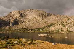
1. Unfortunately, I'm not too sure. The ascent looks like it shouldn't be a problem. Descent looks steeper but probably doable? I'd expect some snow on the descent though. There was a good amount just on our descent of Hailey Pass. That's the pass on the left.
View attachment 79869
2. You could definitely get there in either vehicle. It has some good pot holes and big rocks sticking out, but I always think about whether my Civic could make it up the roads I drive to trailheads, and I was pretty confident I could do it if I drove it carefully. So a minivan should be fine. Just drive aware because some of those potholes, hit at high speed, could be a bad deal.
3. You could bring microspikes just in case, since those north-facing ascents on your route will likely have some snow still. I didn't use mine when we were on snow though because the snow seemed to be at the point where it would just ball up on the spikes and make walking harder. We just used trekking poles for stability and potential self-arrest and no one ended up sliding anyway. There's definitely going to be a lot less snow now because of the warm temperatures we've had all over the past week, and it'll still be warm this coming week. So if it were me, I'd skip the axe and pack the spikes. But I'm also not terribly experienced or well-versed in that and someone else could probably give you more certain advice.
Thanks for the prompt and thorough response! If anyone else has opinions/input on questions 1&3, please chime in!


Assuming he's not on one of his multi-week forays into the wilderness!hopefully he'll chime in since he's been tagged.
Fording shouldn't be much of an issue. None of our fords were that bad and the weather was warm during our trip. The snowpack is even lower now, probably mostly melted, so flows are certain to be even less than when we were there. Peak flow was probably very early July.I'm planning a 5 day loop early next week similar to Jackson's (but returning via Lizard Head Plateau and Jackass Pass instead of Washakie), and I'm a little concerned that all the recent warm temps might lead to some dangerous fords. This'll be my first time in the Winds.... Any locals have an opinion on whether there will likely be unsafe creek crossings on that route next week? Thanks in advance!!
I'll be there the week before. I'll be sure to post a trip report.I’m going out via Big Sandy trailhead first week of September. We shall see what we shall see.
I’ll be on the lookout. Have a great trip. I’m going into the Sawtooth’s last week of August. Hiding out over the holiday.I'll be there the week before. I'll be sure to post a trip report.
Fording shouldn't be much of an issue. None of our fords were that bad and the weather was warm during our trip. The snowpack is even lower now, probably mostly melted, so flows are certain to be even less than when we were there. Peak flow was probably very early July.
Here's the flow of the Big Sandy River at Farson over the past month.
And here's the flow of the Little Wind River over the past month.
Those are the two major rivers you'll be around, and most creeks you cross drain into them, so you can reasonably infer that most to all of the tributaries have had similar trend throughout July.
Hope you have an awesome trip!
I’m late to the party as usual, and I’ll likely fall asleep on the couch. Yeah, that’s a go. Nothing scary.If the snow isn't an issue, the Pyramid Lake to Hailey Pass route should go. Looked at it myself, just never had the opportunity to try it yet. Actually discussed it with @Dreamer when I met him on the top of Hailey Pass a couple years ago. I seem to recall that he's done it, but hopefully he'll chime in since he's been tagged.