Wind River Mountain Conditions 2019

Artemus

I walk
.
Joined
Jun 25, 2012
Messages
4,429
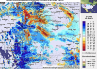
Well, this is interesting. Contrast this "Departure from Normal" map of the region to the one I posted in the OP from last year. Admittedly they are from much different dates but each compares the current conditions to the average or normal conditions for that date. For this new tracking thread note the Wind River Mountains. Even though most of the region has had above normal snowfall and snowfall stored on the ground this year the Windies are an aberration as are the Bighorn Mountains and much of the Greater Yellowstone.

The Wasatch and Bear River range in Utah, the Wyoming range and the Beartooth's in Montana and Wyoming are all well above normal for this time of year but the Windies are different.

This indicates to me that maybe we can get into the high country of the Windies (and Yellowstone and the Bighorns) a little early again this year while in many other places we are going to be postholing in snow in the high country through June and July.
Region capture 10.png
 
Last edited:
S. Montana and the Yellowstone region were quite a bit below normal until some big snows hit in Feb. I'm watching the N. Absarokas, and there's still plenty of snow up there, but I'm starting to see some high ridges go from white to brown, and it hasn't even been that warm, maybe high 40s for the past week or so in the valleys.
 
This indicates to me that maybe we can get into the high country of the Windies (and Yellowstone and the Bighorns) a little early again this year while in many other places we are going to be postholing in snow in the high country through June and July.
That's decent news for me. Planning a trip for the southern Winds in mid-July with a couple east coasters. We're already planning on bad mosquitoes, but a guaranteed lack of snow would be ok with me. I was in the same area in mid-July of last year, and snow was nonexistent in most places, so I guess that's already a good sign.

I always prefer that all mountains have a great snowpack, of course, but you gotta take whatever mother nature throws out and run with it.

Do you have a link to the page that generates this model?
 
Things always even out to about normal. Still have a lot of spring to go.... Melt can still go either way.... As I look out my window there is just under 5 feet on the level.....
IMG_20190402_140919948.jpg
 
Now as for the Wind Rivers, expect a Late Snow melt this year. There was an article in the morning's daily paper here in Jackson Hole, Wy. This is what was in the article for the peak of the runoff for the local Jackson Hole area. It said the peak would not be till early June and late. But the runoff in the rivers would not be as high as previous years the article said.

Now we at first part of the winter were below normal. Then February hit and we were clobbered here in NW Wyoming. And since then it has been a cold spring with a slow melt of of the snow here in the lower elevations. But the weather forecast is calling for at least two weeks of snow and rain on an almost everyday continual basis. This will mean rain / snow in the valleys, but all snow up high. It is only only the beginning of April so anything could still happen. In the bigger weather picture, Alaska and way north like Juneau are having fabulous weather right now with a snow drought. The other day Juneau, Ak. had near 70 degrees. So nice weather to the north. And the southwest right now is having seemingly nice sunny weather also. This means all the storms coming thru the west are being funneled north of Southern Utah (like north of Zion NP and area) and south of Canada - which brings the storms right thru Northern Utah, Idaho, and Wyoming. So from what am seeing right now, expect a bunch of snow to hit the Wind Rivers in these next two weeks up high. Also expect more snow for the Absarokas, Yellowstone, the Wasatch in what I am seeing and in my opinion.

The Snotel Sites have dropped all thru out NW Wyoming. It has been a cool spring but no big storms have passed thru as of late ... here is the Snotel Basin Drainage Area Percentages for several areas right now in Wyoming ....

Snake River Drainage ... 108%
Madison Gallatin ... 119%
Yellowstone ... 107%
Wind River ... 99%
Bighorn Basin ... 88%
Shoshone River ... 101%
Sweetwater ... 94%
Upper Green River ... 97%
Lower Green River ... 99%
Upper Bear River ... 110%

Again everything could change with the forecast calling for locally and thru out the whole area, everyday rain and snow (snow up high) for at least the next two weeks. Plus here in the Town of Jackson and the area .... the snow is still here everywhere. A late spring folks.

For whatever it is worth. Wishing Everyone the Best!
 
Good site. Most recent (Apr 30) looks highly similar. I'd like to say it's slightly improved. Just hope lack of snowpack doesn't translate to yet more fires in the area. Last year's near Pinedale/Bondurant was huge. But, maybe late Spring rains will come. They certainly are in the NE, S. Utah and elsewhere!
 
That fire was man caused in beetle kill and dying timber.... Pushed by 50 mph winds for over a week. We had temps of 15 at night 50 in day.. unfortunately spring rains make late season fires worse.. needs the fall moisture
 
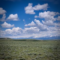
Just back from visiting a new camp spot at South Pass just south of the Wind Rivers at 8,200'. No snow and the snowline was over a thousand feet above us and there had not been snow for weeks. Here is a picture of the main range looking north. The highest peak, left of center and standing alone, is Wind River peak at 13,192'. The snow line looks to be 9K' to 9.5K'. I'll bet even the south facing approach trail to Sweewater Gap may be mostly snow free. As of May 15 the road to Big Sandy opening trailhead was not quite open but I presume it is open now. That forest has not published a status since May 15. The mid elevation Wind Rivers are open for business. Skeets were almost non-existent at south pass thus far. Pronghorn antelope were in profusion. Caveat emptor - the southern Wind Rivers melt off faster than the northern part of the range and the highest land and peaks all through the range may hold snow all year this year.

78805

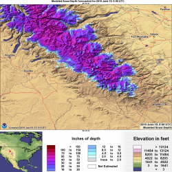
Here is the snow depth model set to show June 19th's depth. Yes, there is still a lot up there.
78806
 
Last edited:
So probably not till mid-July till we get up around even sweetwater @Artemus ?
Yup. Killing my buzz a little. And @Jackson's. I think the Sweetwater Gap area and the peak we climbed or the drainage going up to Temple or Wind River peaks from the south may be our earliest, best bet. I am also liking south facing east fork to hope for.
 
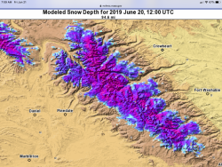
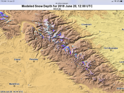
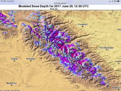
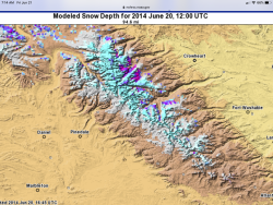
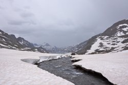
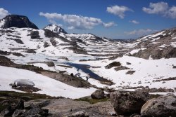
I just finished my drive west. Am now in Steamboat and headed up to Pinedale in a few days. I shall see. Did a little comparison between this year, last year, and two high snow years from the recent past.


AB392764-8418-4C17-8884-E24AA937CE7E.png


CCC23339-15C4-4CE2-9595-CC76D58E3DA0.png


C8E4FA27-F6AD-4A48-9C15-A09B13D8A569.png


2A329DFC-5B0E-49F0-8E25-76E4AB2BBB61.png


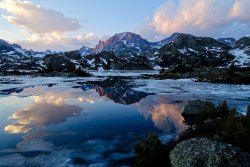
Island Lake July 7, 2017
3808F486-0A06-4BEF-BD4A-63F4FDBC3F74.jpeg


Titcomb Basin July 11. 2014
36DCE684-98F5-4F5D-9FF0-B626A0C36275.jpeg


Indian Basin July 13, 2014
16B4A25C-4D6A-4288-96F5-FBF1568EC103.jpeg
 
I just finished my drive west. Am now in Steamboat and headed up to Pinedale in a few days. I shall see. Did a little comparison between this year, last year, and two high snow years from the recent past.


View attachment 78936


View attachment 78937


View attachment 78938


View attachment 78939


Island Lake July 7, 2017
View attachment 78940


Titcomb Basin July 11. 2014
View attachment 78941


Indian Basin July 13, 2014
View attachment 78942
It's looking to be fairly warm and sunny up that way for the next week+, so hopefully that will help melt things off. You headed into the mountains as soon as you get to Pinedale?
 
You headed into the mountains as soon as you get to Pinedale?
I’ll do a couple short exploratory hikes right off. Likely Photographers Pt. and Marms Lk. to scope the scene. Takes me a while to organize my resupplies. I have a friend in Pinedale with a drift boat and I’ll hopefully get them to float and fish a bit. I may take a ride elsewhere to pass some time. I like Craters of the Moon a lot. I want to get into the Winds yesterday, but I’ve been around enough to know better. Even if we do have an extra rapid melt I expect there is going to be plenty hanging on throughout the summer. The bugs and creek crossings are going to be heavy duty. Those comparison snow depth images above are really dramatic.
 
Thanks for posting that Dreamer! It looks worse than I hoped. Does anyone have any recommendations for good early-season routes in the Winds? I'm hoping to head up there in late July (it looks like that will be early season this year!), and I'm now fearing that most of the routes I know of will still have too much snow on the passes. For all of you who are heading out there between now and then, would you mind posting the conditions here after your trips? Thanks!
 
I’ll do a couple short exploratory hikes right off. Likely Photographers Pt. and Marms Lk. to scope the scene. Takes me a while to organize my resupplies. I have a friend in Pinedale with a drift boat and I’ll hopefully get them to float and fish a bit. I may take a ride elsewhere to pass some time. I like Craters of the Moon a lot. I want to get into the Winds yesterday, but I’ve been around enough to know better. Even if we do have an extra rapid melt I expect there is going to be plenty hanging on throughout the summer. The bugs and creek crossings are going to be heavy duty. Those comparison snow depth images above are really dramatic.
I was up around Marms Lake last year around July 15, and the bugs were incredibly bad then, so I can't imagine what they'll be like this year with how wet it has been. Was hoping to be up around there again this year from July 13-16, but the data makes me think I'll want to strongly consider alternatives.

If you have the time and ability to report back on here after checking some of those spots out, I know I and others would appreciate any updates you can offer! Really appreciate your comparative post as well.
 
Thanks for posting that Dreamer! It looks worse than I hoped. Does anyone have any recommendations for good early-season routes in the Winds? I'm hoping to head up there in late July (it looks like that will be early season this year!), and I'm now fearing that most of the routes I know of will still have too much snow on the passes. For all of you who are heading out there between now and then, would you mind posting the conditions here after your trips? Thanks!
Dad's Lake, Marms Lake, on up to Pyramid Lake was very nice in the middle of July last year. Hopefully thawed out sufficiently by late July this year. Probably a high likelihood of tons of mosquitoes and soggy ground though.
 
I just finished my drive west. Am now in Steamboat and headed up to Pinedale in a few days. I shall see. Did a little comparison between this year, last year, and two high snow years from the recent past.


View attachment 78936


View attachment 78937


View attachment 78938


View attachment 78939


Island Lake July 7, 2017
View attachment 78940


Titcomb Basin July 11. 2014
View attachment 78941


Indian Basin July 13, 2014
View attachment 78942
That pic of Island Lake in July of ,14 is absolutely stunning - just saying..
 
Thanks for the suggestion Bob. From the little that I've read about that loop, it might be more than I am willing to attempt on this trip. I'll keep it in mind though.

I'm thinking I may go out tomorrow and buy an ice axe and maybe crampons, and go practice self-arrest a couple of times in the next several weeks. That would at least give me a little more flexibility if passes are still snowed in. I would only attempt relatively easy passes though.

Here is another conditions report: https://www.greatoutdoorshop.com/blog/2019/06/21/trailhead-conditions-report-06-21-19/
 
Similar threads
Thread starter Title Forum Replies Date
andyjaggy Wind River Range Roberts Mountain Trip Planning 4
meowtaingal Wind river high route mid september Trip Planning 7
D Wind River offtrail route questions Trip Planning 28
W Greetings from the West Side of the Winds (Wind River range) Noobs: Introduce yourself! 5
marquiri Wind River Range - Angel Pass Trip Planning 24
Mikjik86 Backpacking The Wind River Range - Wyoming, September 2022 Trip Reports 3
R Wind River Range: Green River Lakes/Clarks Trail/Porcupine Creek Trail Trip Planning 3
Mikjik86 Another Wind River Trip Planning! Elkhart/Titcomb/Knapsack/Shannons Pass loop back to Elkhart, or continue to Green River Lakes Trailhead? Trip Planning 10
wsp_scott Wind River Range Sept 2021 (part 2) Backpacking 4
wsp_scott Wind River Range Sept 2021 (part 1) Backpacking 16
B Wind river range mid sept. Trip Planning 8
marquiri Wind River Range - September 2022 Trip Planning 31
TheMountainRabbit Northern Wind River Traverse (Bridger/Fitzpatrick Wilderness) - September 2021 Backpacking 16
D Wind River Blowdown Trip Planning 2
westy Wind River Range Backpacking 4
Artemus Wind River Mountains Conditions 2021 Trip Planning 17
eobie Wind River Blowdowns Situtation... Trip Planning 14
wsp_scott Wind River Range (beginning of Sept 2021) Meet Up (Members Only) 11
TheMountainRabbit NW Wind River Range (Bridger Wilderness) - August 2020 Backpacking 3
travel2walk trip report: Wind River Range – Ross Lakes, Bear Basin, Grasshopper Glacier, & Dinwoody Creek loop, Aug-Sep 2020 Trip Reports 41
marquiri Wind River Range - Green River Lakes Trailhead Trip Planning 9
Gunnahafta Green River <> Big Sandy WIND RIVER RANGE Trip Planning 1
M 5 days Green > Elk Wind River route advice August 17th Trip Planning 9
Matt Van Natta HELP: Wind River Range, Baker Lake to Green River Lakes Trip Planning 7
T Grizzly bears in Wind River Mountains Noobs: Introduce yourself! 12
Dreamer Wind River Dreaming | Summer 2019 July 17 - July 29 | Green River Lakes - Elkhart Park Backpacking 14
Artemus Wind River Mountains Snowpack 2019/2020 Trip Planning 12
S Backcountry camping tips for Wind Rivers - upper Green River valley via canoe Trip Planning 5
TrektheWorld Wind River Range 5 Day Loop Backpacking 16
Hiker Seth Thinking about this Wind River Route. Trip Planning 11
H Wind River Range route planning Trip Planning 6
Dreamer Wind River Dreaming | Summer 2014 the first few days July 9 - 14 Backpacking 5
10KFly Wind River Range in Late September Trip Planning 6
b.stark Wind River Range 2009 "From The Vault" Backpacking 9
blueeyes Wind River Range August 2018 Backpacking 11
Lowro East Temple Peak - Wind River Range Backpacking 13
DuneElliot Backpacking Wyoming's Wind River Range, August 2018 Backpacking 4
b.stark Wind River Range 2007 "From The Vault" Backpacking 4
Wolverine1875 Wind River Range: Llama Trekking from Dickinson Park to The Cirque of The Towers Trip Planning 19
Dreamer Wind River Dreaming | Summer 2012 trip 3 July 22 - August 8 | part two Backpacking 2
Bob Wind River Mountains Trip Planning 2
N Wind River and Medicine Bow Peak July 6-13 Backpacking 3
Curt Wind River Range - July 2018 Backpacking 26
DaveNC Wind River Range August-September - with time to roam Trip Planning 8
Dreamer Wind River Dreaming | Summer 2012 trip 3 July 22 - August 8 Backpacking 19
pstm13 Texas Pass Cirque of Towers Lower Wind River Range August 2018 Trip Planning 7
Artemus Wind River Mountains Conditions 2018 Trip Planning 45
DuneElliot Wind River Range, WY: August 2018 Trip Planning 3
Cburton A week along the Continental Divide in Wind River Range Backpacking 20
D Wind River High Route Trip Planning 4

Similar threads

Back
Top