When might road to Salt Creek TH be ok?

Janice

Member
.
Joined
Dec 5, 2017
Messages
1,050
Months ago I got a permit for 5 nights in the Needles to head down Salt Creek and eventually make it to Chesler Park, starting in about two weeks. Our plan was for Coyote Shuttle to drive us to Cathedral Butte TH and stay SC1, SC3, Open Zone, LC1, EC3 then exit. I had been delighted to get almost all of our 1st choice campsites. But Winter 2023 had other plans for us... NPS says the road to the TH is impassable and will remain that way for awhile. We've created a Plan B, to start at the Needles CG and stay Open Zone, then head up to SC3 and do as much exploration between SC3 and SC1 as possible, then head back down and continue as originally booked, staying at Open Zone (again) and beyond. To do Plan B, I have to change SC1 to Open Zone for our 1st night, and I haven't done that yet; I have a tiny hope that the road might be passable after all and we'd hate to give up SC1 prematurely. But we also don't want to lose the opportunity to get an Open Zone permit for the 1st night. Because of conditions, they're reserving Open Zone based on # people rather than # groups, so there are still spots left, but you never know how things might develop.

SO my question is: Does anyone have a sense of the roads in that area and think there's a possibility Bridger Jack Rd (107) will be passable two weeks from now (in contrast to what the NPS says)? I welcome your info and advice.
 
Hi Janice,

It might be worth emailing the fantastic couple, Amber and Caleb, who run Needles Outpost (needlesoutpostut@gmail.com), which is the private campground/store just outside of the park.

They often explore the surrounding area themselves and with clients in their ATVs, so would be able to give you another perspective on how the local roads are looking at the moment.

In fact, it might be worth asking if they could shuttle you to Cathedral Butte TH.
 
Last edited:
Thank
Hi Janice,

It might be worth emailing the fantastic couple, Amber and Caleb, who run Needles Outpost (needlesoutpostut@gmail.com), which is the private campground/store just outside of the park.

They often explore the surrounding area themselves and with clients in their ATVs, so would be able to give you another perspective on how the local roads are looking at the moment.

In fact, it might be worth asking if they could shuttle you to Cathedral Butte TH.
This is super helpful. Thanks - I will contact them!
 
See if you can find how far the road goes before closure - the road to the trailhead might be impassable, but parking your rig and walking a few miles or two isn't a big deal is it?
 
@Janice - just walked in and talked with a more senior ranger at the The Needles visitor center.

Road to Cathedral Butte: There are several feet of snow up there. Somebody tried to drive out recently in a proper vehicle and didn’t even make it half way from the paved road. Got stuck and had to get towed out.
They expect it’s going to be a long while before you can get close, like May! o_O
The ranger said they get their info directly from the BLM office in Monticello- so best to call them directly for updates about the road to CB.

Then Lost canyon has a lot of water now, multiple water crossings are necessary, shin deep.

The rest of the regular day area hiking routes are all clear, no ice, no snow. Mud, water and big pools in the canyons are more of a concern. Lost canyon being the wettest.
No ice on the ladders and no ice on the moki steps.
 
@Titans - you are amazing! This is incredibly helpful, as you know I have been deliberating about this a ton. I actually had on my list for tomorrow to contact Monticello BLM.

Regardless of how we start our trip, I am thrilled to hear that we won't have to worry about ice on the other parts. That is great news for ALL of us who are excited to hike in the Needles right now.

I hope you two have a wonderful time there. It will be great to hear about your adventures!!!
 
Interesting. Were you ever there early in the season when the road was snowy? If so, I'd love to hear what that was like, including if the initial descent on the trail was difficult (snow/ice on the steep sections, etc.).
 
Interesting. Were you ever there early in the season when the road was snowy? If so, I'd love to hear what that was like, including if the initial descent on the trail was difficult (snow/ice on the steep sections, etc.).

I drove up there during a winter storm a couple years ago and it's not an experience I care to repeat. The descent of the trail was steep and slippery at first, but nowhere near as bad as the drive.

 
Great to read your report. Sounds like that muddy road was intense!

I've enjoyed a lot of your reports, including others from the Needles, but I had missed this one. Beautiful photos as always!
 
@Titans - you are amazing! This is incredibly helpful, as you know I have been deliberating about this a ton. I actually had on my list for tomorrow to contact Monticello BLM.

Regardless of how we start our trip, I am thrilled to hear that we won't have to worry about ice on the other parts. That is great news for ALL of us who are excited to hike in the Needles right now.

I hope you two have a wonderful time there. It will be great to hear about your adventures!!!

We met several guys yesterday on the Peekaboo trail in the same boat as you, nobody is able to drive to Cathedral Butte now or any time soon. Some maintained their Peekaboo campsite- others did day hikes.

We were surrounded by snow squalls yesterday and dodged them till the evening and night in the CG. Very windy during the squalls and cold! There’s snow on the ground this morning, but it will soon be gone.

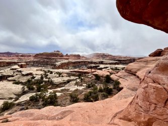
View from the end of the Peekaboo trail towards Salt Creek and maybe Cathedral Butte? Snow squalls everywhere!

9182824B-B1E2-476C-973A-52DA2F829338.jpeg

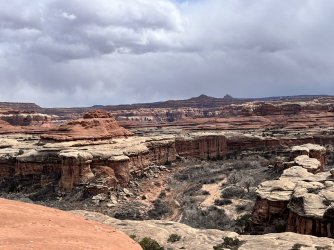
View into Salt Crerk
C3AF57C7-5E99-4EF3-A5A2-FAFF9CF8B36A.jpeg
 
Any updates? Did you have to change your itinerary? I'm in the same boat for a May 5th start date. Any info on the road conditions would be greatly appreciated. I'll be calling around to NPS, BLM and Needles Outpost tomorrow.
 
Any updates? Did you have to change your itinerary? I'm in the same boat for a May 5th start date. Any info on the road conditions would be greatly appreciated. I'll be calling around to NPS, BLM and Needles Outpost tomorrow.
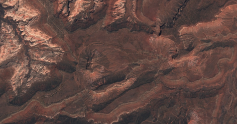
I pasted a Sentinel capture from Apr 29. Looks like the recent warm weather has melted the road out. One concern I would still have is whether the crossing of Indian Creek at the start of the road is high because of recent melt. The forecast for later this week is for pretty cool conditions so that may help.

1682964761190.png
 
The river crossing is what I'm trying to get some detailed info about. I'm familiar with the road and as long as it's dry it shouldn't be a big deal.
 
From the latest ( 5/1 ) Canyonlands Road Report

  • Beef Basin Road/Bridger Jack Road/CR-107: Impassable due to high flood waters produced by rain and snowmelt cutting off access, including access by high clearance 4WD vehicles. Conditions change quickly and water may rise rapidly. Visitors may not be able to access the south boundary of The Needles or Cathedral Butte Trailhead at this time.
 
Hey gang. I've been anxiously holding to bump this and can't wait any longer. I am hoping to take Beef Basin rd to the upper Salt Creek TH at Cathedral Butte next Wednesday. I'll be calling in to BLM and NPS tomorrow but also wanted to ask if anyone here has input. Thanks!!
 
Up the road out of canyonlands from Bobby's hole is always tough... If that's the way you are talking
 
No sir I am thinking of coming up 211 from the south and east, then turning on to Beef Basin rd not far past Newspaper Rock. I believe Indian Creek is what I'll need to cross almost immediately.

Edited to add the coordinates near turnoff 38.0835564, -109.5688193
 
Similar threads
Thread starter Title Forum Replies Date
Bob Watch this for when you think you might call SAR ...... General Discussion 4
Rockskipper Might want to stay away from Virtika products General Discussion 15
Langdon Greene 2016 might be your best chance to do Wonderland (Rainier) Trip Planning 2
TrailScot Hole-in-the-Rock Road - Escalante General Discussion 11
Titans Cedar Mesa 3/11/24- Springs & Road conditions Trip Planning 3
Noun Sequitur 2023 Road Trips Everything Else 1
Outdoor_Fool Brooks Range trek - Anaktuvuk Pass to the Haul Road - Cancelled Flight - last minute change-up Backpacking 21
Writhdar Old Sheffield/Spencer Flats Road end (wellhead) questions Hiking & Camping 4
SteveR Sheep River Road Ride on May Day Everything Else 2
regehr conditions at the Mexican Mountain road? Trip Planning 8
rhubarrbb White Pocket - Lone Tree Road / Southern Road Trip Planning 3
regehr maze road has a sand dune Trip Planning 14
TrailScot "I'll take the High Road ..." - A Loop Hike around the Canyons of Needles - May 2022 Trip Reports 14
Stephanie B Lockhart Road and Bobby's Hole Trip Planning 7
F Who has been here? Ruin off Hole-in-the-Rock road General Discussion 4
RyanP road from Hite to Water Hole Flat Trip Planning 20
D White Rim Road Off Road 2
Parma White Rim Road FKT General Discussion 4
Gwen T Fortymile Ridge Road Trip Planning 5
T Status of Traffic - Hole in the rock road - Escalante - September? Trip Planning 2
fossana Red Cliffs & Dixie NF fire-related trail/road closures (St George area) Trip Planning 1
norwegianxplorer Death Hollow from Hells Backbone road 7 day loop with My Own Frontier Canyoneering 0
Titans 2020 Road Conditions Southern Utah (& Arizona Strip ) Trip Planning 1
Artemus Road Proposed to be Bulldozed through Red Cliffs Recreation Area General Discussion 7
regehr late 2019 road conditions in S Utah Trip Planning 55
Titans COLORADO PLATEAU ROAD TRIP - November & December 2018. Hiking & Camping 21
powderglut Colonnade Arch road conditions General Discussion 7
J How is the dirt road to the East Fork of Blacks Fork TH? Trip Planning 1
Ross Arizona/Utah road trip loop with sandstone/badlands/canyon hikes Hiking & Camping 14
C Skutumpah road closed at Bull Valley Gorge General Discussion 9
kwc Canada road tripping Northwest Territories question(s) General Discussion 2
Parma Elephant Hill Road Advice General Discussion 1
fossana Death Valley road closures post flooding Trip Planning 3
canadug Current Escalante and Cap Reef Road conditons Trip Planning 17
fossana Kolob Canyons (Zion NP) still closed for road construction Trip Planning 2
wesleyS The Maze road conditions Off Road 0
Titans 3 week Arizona road trip: Tucson Desert Rain & Hiking SAGUARO NP Hiking & Camping 1
P Tuckup Canyon Trailhead road conditions Trip Planning 0
Rockskipper The Road to Tuk Off Road 8
RyanP White Rim Road vehicle/difficulty questions Trip Planning 8
wesleyS Road from Boulder airstrip, UT Hiking & Camping 5
Nick PNW Road Trip Trip Planning 20
Dustin Gent Red Breaks via Spencer Creek Road General Discussion 1
Strawsome What is your favorite hike in the Escalante/Hole in the rock road area? General Discussion 6
H Wahweep Hoodoos access road Trip Planning 1
Nick Grand Bench Road Trip Planning 15
Dustin Gent San Juan Mountain backpacking/road questions General Discussion 3
Rockskipper Has anyone driven the Denali road to Wonder Lake in their own vehicle? General Discussion 11
Mike Jones Smithsonian Butte Road Utah BLM camping? Trip Planning 5
Perry Capitol Reef NP Hiking and Road Trip Suggestions Wanted Trip Planning 1

Similar threads

Back
Top