Uintas Conditions 2019

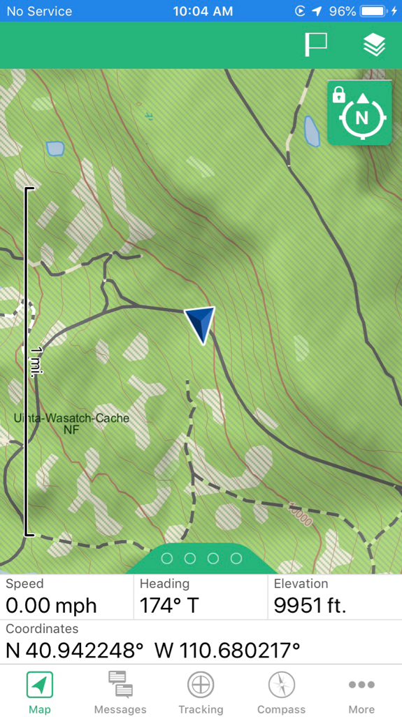
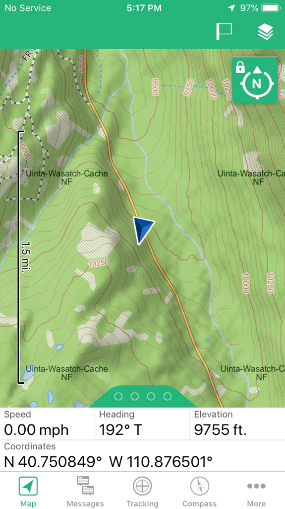
The Trial Lake snotel is at about 9900 feet and it’s saying 26” as of 1:00 today. It’s lost 3” in the last 24 hours. While the access to the high country is later this year *I think* there’s going to be a fast melt. But I’m no meteorologist, I just play one on backcountry forums.;)

I'm planning on being out here 2nd week of July. Curious what the estimates of the snow are looking like. I did Alpine Lakes Pass in the winds in August 2017 using microspikes and poles, and it wasn't terrible, but wasn't easy.

Any sense of the angle/snow composition at that time? Will it be hard ice or soft corn?
You're definitely looking at softer snow in July than in August. By August, snow has pretty much turned to glacier and you really dont posthole unless it's real late in the afternoon.

The snow in the Uintas in July will be softer (though still supportable in the mornings) and far more widespread than your Winds adventure. Timing will be key in order to avoid frustratingly slow travel.
 
Did some recon on the north end of MLH today....

Rivers and creeks are raging. Most are out of their banks.

North Slope Road is still closed near Elizabeth Ridge right here...

7a84a1ae5259ae8674fbfa8cdfe5465a.jpg
810e47a5023f18fe72450d2e9fade7c6.jpg


MLH is closed approx 1/2 mile south of the Kletting Peak historical marker. Right here...

e8df4d53f360154e7f1d8876847d65d1.jpg
b2e5753232a42d7f24fc99bdbdad671c.jpg


Hiked up Bear River Smiths Fork trail to Deadman Mtn 10,750 ft. About four feet of snow on top. Trail snow free until Deadman Pass at 10,500 ft. All west/south facing. Shaded and north east facing slopes still have a ton of snow. Slushy, post holing up to the waist yikes! Very inconsistent to make matters worse.

Very green and beautiful where you can get to!


Sent from my iPhone using Tapatalk
 
Last edited:
Oh, and, the ranger at the Bear River Ranger Station said UDOT ran out of funding and now won’t be clearing the road until July 1st.


Sent from my iPhone using Tapatalk
 
You're definitely looking at softer snow in July than in August. By August, snow has pretty much turned to glacier and you really dont posthole unless it's real late in the afternoon.

The snow in the Uintas in July will be softer (though still supportable in the mornings) and far more widespread than your Winds adventure. Timing will be key in order to avoid frustratingly slow travel.
Any sense of what pct of the trail will be snow-covered in 3 weeks? Seems to be melting pretty quickly according to the snotels, but they are a bit lower than the passes.

Is it worth bringing snowshoes?
 
Attempted to drive the Red Cloud Loop outside of Vernal this weekend. Ran into snow across the road up high around 10,000 ft. Everything is melting and just mush up at that elevation. Still tons of snow up high, it's going to be a while before backpacking in there this year.
 
I thought this was interesting and worth sharing . . .

I did a 10 year historical view of the snotel at Trial Lake on June 17.

8 of those 10 years had zero snow. The two that did. Not surprisingly,
2011 and 2019.

The good news is that 2019 is 2/3 less (19" vs 56") than 2011.
 
The thing that’ll get ya this year will be drifts hanging around foorrrreeeevveeerrr.


Sent from my iPhone using Tapatalk
 
Thanks for all of the great information posted here. I have a question that I understand may be difficult to answer, but I would appreciate some input from those of you who have experienced planning and executing trips into the Unitas on these larger/longer snow years. I'm just recently getting back into backpacking and have yet to attempt a trip that falls in this time frame at the fringe of the high county being open (I thought I would have one last year in mid-June, but everything was GTG so early last year, it was not a good gauge). Further, the trip I am planning is with my bro-in-law who will be returning to Utah for a short time on leave from the army, so we don't have much flexibility on schedule.

My original goal was to plan a 2-3 night trip into one of the Uinta basins that rests in the 10,500' (no passes). Timing for around June 30-July 3. My bro-in-law has been in Europe for the last 3 years and wants to prioritize solitude so we would like to avoid anything accessed via MLH or the Grandaddy area. I'm leaning towards the south slope vs the north slope, hoping the conditions would be a little better. I have some plans of where I would like to go and they mostly fall into the above description.

Any thoughts on whether this will even be a possibility? Or should I start prepping now to use a backup plan?

Thanks in advance.

Anything not involving major passes might not provide a lot of solitude. Otherwise Red Castle and Deadhorse lakes are a good deal.


Sent from my iPhone using Tapatalk
 
Thanks for all of the great information posted here. I have a question that I understand may be difficult to answer, but I would appreciate some input from those of you who have experienced planning and executing trips into the Unitas on these larger/longer snow years. I'm just recently getting back into backpacking and have yet to attempt a trip that falls in this time frame at the fringe of the high county being open (I thought I would have one last year in mid-June, but everything was GTG so early last year, it was not a good gauge). Further, the trip I am planning is with my bro-in-law who will be returning to Utah for a short time on leave from the army, so we don't have much flexibility on schedule.

My original goal was to plan a 2-3 night trip into one of the Uinta basins that rests in the 10,500' (no passes). Timing for around June 30-July 3. My bro-in-law has been in Europe for the last 3 years and wants to prioritize solitude so we would like to avoid anything accessed via MLH or the Grandaddy area. I'm leaning towards the south slope vs the north slope, hoping the conditions would be a little better. I have some plans of where I would like to go and they mostly fall into the above description.

Any thoughts on whether this will even be a possibility? Or should I start prepping now to use a backup plan?

Thanks in advance.

When I want solitude I go high, I go early in the year, and I go during the middle of the week. Seems to work out. If you plan appropriately, you should be fine pretty much anywhere you go. A little snow isn't that big a deal.

I have a trip planned on the 27th/28th and I'm expecting plenty of snow on passes so we'll see how things go.
 
Forest Service update:
Mt. View Ranger District Henry's Fork update wilderness rangers/volunteers were out this weekend, they made it to Elk Horn Crossing without having to walk through any snow, there is a big drift of snow from the bridge crossing over to Dollar Lake. Horses are able to make it to Alligator Lake.
 
Looks like they aren't going to start plowing the Mirror Lake Highway until June 17th this year and they think it'll take about a week once they do.

I reached out to the forest on their FB page begging for snow blowing pics and status and they said they would post some:

UPDATE - looks like I am no good linking to a FB post. Keep an eye on their post page yourself...
 
Last edited:
Did some recon on the north end of MLH today....

Rivers and creeks are raging. Most are out of their banks.

North Slope Road is still closed near Elizabeth Ridge right here...

7a84a1ae5259ae8674fbfa8cdfe5465a.jpg
810e47a5023f18fe72450d2e9fade7c6.jpg


MLH is closed approx 1/2 mile south of the Kletting Peak historical marker. Right here...

e8df4d53f360154e7f1d8876847d65d1.jpg
b2e5753232a42d7f24fc99bdbdad671c.jpg


Hiked up Bear River Smiths Fork trail to Deadman Mtn 10,750 ft. About four feet of snow on top. Trail snow free until Deadman Pass at 10,500 ft. All west/south facing. Shaded and north east facing slopes still have a ton of snow. Slushy, post holing up to the waist yikes! Very inconsistent to make matters worse.

Very green and beautiful where you can get to!


Sent from my iPhone using Tapatalk
Thanks pal!
 
Oh, and, the ranger at the Bear River Ranger Station said UDOT ran out of funding and now won’t be clearing the road until July 1st.


Sent from my iPhone using Tapatalk
BULL PUCKY! (anybody remember that reference?)
I've paid use fees to the forest for the MLH for most of my adult life and not used one square of toilet paper. Where is the agency fund sharing love ???? :)

"for most of my adult life.." Oh, and that is not a short time...
 
Any sense of what pct of the trail will be snow-covered in 3 weeks? Seems to be melting pretty quickly according to the snotels, but they are a bit lower than the passes.

Is it worth bringing snowshoes?
What trail?
 
Anything not involving major passes might not provide a lot of solitude. Otherwise Red Castle and Deadhorse lakes are a good deal.


Sent from my iPhone using Tapatalk
Thanks Perry! Both of your suggestions are great ones. I've shifted my focus to the south slope because I'm visioning better conditions. Is thinking the south side will melted out more than the north side a false assumption?

I've been watching a few snotel stations and monitoring the melt that way. Based on just that, it appears elevation plays the largest factor, but some locations aren't what you would expect based on elevation alone.
 
Last edited:
When I want solitude I go high, I go early in the year, and I go during the middle of the week. Seems to work out. If you plan appropriately, you should be fine pretty much anywhere you go. A little snow isn't that big a deal.

I have a trip planned on the 27th/28th and I'm expecting plenty of snow on passes so we'll see how things go.
Thanks Eric O!
 
Thanks Perry! Both of your suggestions are great ones. I've shifted my focus to the south slope because I'm visioning better conditions. Is thinking the south side will melted out more than the north side a false assumption?

I've been watching a few snotel stations and monitoring the melt that way. Based on just that, it appears elevation plays the largest factor, but some locations aren't what you would expect based on elevation alone.

South facing is a good bet. I was up on Saturday and I purposely picked a south/west-facing trail and it was snow free. Once into the dark trees or on north/east-facing slopes there was still plenty of snow. I maxed out at 10,700 ft so I wasn't terribly high.
 
Last edited:
Similar threads
Thread starter Title Forum Replies Date
Upgrayedd Uintas Conditions 2023 Trip Planning 39
2eez4life Uintas Conditions 2022 Trip Planning 18
Upgrayedd Uintas Conditions 2021 Trip Planning 9
Upgrayedd Uintas Conditions 2020 Trip Planning 69
Dave Uintas Conditions 2018 General Discussion 210
Dave Uintas Conditions 2017 General Discussion 128
Jackson Uintas Conditions 2016 General Discussion 93
Vegan.Hiker Wasatch/Uintas conditions late April/early May Trip Planning 6
Upgrayedd Starting a fire in damp conditions in the Uintas General Discussion 14
Nick Uintas Conditions 2015 General Discussion 212
Udink Uintas Conditions 2014 Trip Planning 219
MtnMatt Uintas conditions?? Trip Planning 9
MtnMatt current conditions in the Uintas General Discussion 1
Nick Uintas Conditions 2013 General Discussion 115
Tarp Boy Looking for Shuttle service for Uintas Granddaddy basin trip Trip Planning 0
2eez4life Suggestions: Uintas Backpacking with some rock climbing routes Trip Planning 0
regehr (Uintas) Lake Fork Fun Backpacking 8
scatman Reid's Peak - Uintas - July 22, 2023 Hiking & Camping 6
NorthwestWanderer First time in the High Uintas | Red Castle SNEAK Loop | I give these mountains 5 out of 5 stars Backpacking 7
regehr Uintas this weekend? Trip Planning 4
2eez4life 4 days 3 nights in the Uintas Trip Planning 9
6 Uintas Trip Planning Trip Planning 5
Perry Sunrise/Sunset Uintas Marriage Proposal Location Suggestions Trip Planning 25
N Gilbert Meadows- High Uintas Trip Planning 0
WasatchWill The High Uintas 4-4-4: Four Basins, Four Passes, Four Days Backpacking 20
C High Uintas Wilderness - Last minute plans Trip Planning 4
Mountain Wanderer High Uintas Wilderness - Granddaddy Basin Backpacking 4
scatman Bourbon Lake, Uintas - July 11, 2020 Hiking & Camping 4
ridings82 Uintas Backpacking Loop Trip Reports 12
B Uintas question Hiking & Camping 3
Tarp Boy Uintas in late June? Trip Planning 10
Born to Hike Mountain Solitude: Reconnaissance Lake, High Uintas, early Sept 2019 Backpacking 9
Ehouston24 Uintas Loop (Red Castle/Kings Peak) Trip Planning 14
DrNed Plan B to High Uintas Backpacking Trip Planning 20
DrNed Recommendation for 35-45 Mile Route in the Uintas Trip Planning 7
Yvonne A weekend in the Uintas Hiking & Camping 10
WasatchWill 5 Guys on a Trail: A Tour of the Southwestern Uintas Backpacking 12
wabenho Rainbow Lake, Uintas - September 2018 Backpacking 6
DesertRatShorty Solitude in the Uintas -- Gilbert Lake Loop Backpacking 14
jdfut66 Uintas - Priord Lake to Deadhorse Lake Loop Backpacking 6
Born to Hike Clements Lake and East Basin in the High Uintas, mid-July 2018 Backpacking 6
TrektheWorld Need help with Uintas trip - camping Trip Planning 8
Perry Missing hiker in Uintas - Ray Humpherys General Discussion 104
Mike K Uintas Three Nighter Backpacking 13
LarryBoy In Which I Forget Sunscreen (Uintas 2015) Backpacking 11
Brian Handsaker Uintas Backpacking (or Montana) Trip Planning 9
Uncle_Dim October in the Uintas Trip Planning 2
Perry Late Season Uintas Day Hike Ideas. Bear River to WFBF and Back? Trip Planning 13
r3biker Backpacking trip to Clyde lake in Uintas Backpacking 8
WasatchWill An Intro to the Uintas Hiking & Camping 2

Similar threads

Back
Top