Uintas Conditions 2014

Man, I wimped out of the stream crossing in my Xterra! I'd like to go to McCoy Park, but I'm afraid I won't have enough time to drive that far. If the weather doesn't cooperate, I may go to Cat Canyon in the Confusion Range. It's hard to pick a short weekend hike when you don't live there anymore and you want it to be a good one!
 
I have never been to West Fork Blacks fork. How do you guys usually get there? Do you take the North slope road from the Mirror Lake Highway or drive up and down through Evanston?
 
Yeah, I go from Evanston down to Meeks Cabin Reservoir then to the trailhead. I went in early spring one year, and the road from Meeks Cabin was completely clear, but the North Slope road was still snowed in and very muddy in most places. So the Meeks Cabin route was the only passable route during that time of year.
 
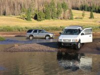
I've always done it via North Slope Road from the Mirror Lake Highway. It's an easy graded road all the way to WFBF, then it turns into a two-track going up the canyon. The last mile or two of the road is accessed by driving your truck right through the river. Good times!

5461893458_0183608be9_z.jpg
 
For those of us with a sedan I assume the river is the end of the line? Is there a bridge or anything for walking over, or do you just have to get soaking wet and fjord it on foot?
 
Depending on water levels, you can pick your way across without getting too awful wet.

And yeah, as Nick said, you can drive the north slope to get there. I think I took the north slope once and then I had to take Meeks Cabin the other time because of the snow on the north slope road.
 
I've never had to cross it on foot, but I would probably just start hiking from the crossing and look for a better way. I fly fished it a bit and I seem to recall there being more crossable spots.
 
Well it is runoff right now, albeit a light one. I think you will have a hard time crossing while wading at the moment and it might even be a spicy crossing.
 
After doing the math on my flight schedule and driving times to trailheads, I think I'll hit Christmas Meadows, instead.
 
Curious . . . I've got a Suburban that I'm pretty sure I could drive through water like that pictured above . . . but I've never done it before - is the technique just gun it through? Or something else? And how do you know when it's too deep to attempt?

How far is this crossing from the trailhead?
 
A Suburban could totally do it. It just takes a bit of blind faith. I imagine you need to wait until the spring runoff is done too. No need to gun it, just slow and steady and keep the doors shut! ;)
 
And how do you know when it's too deep to attempt?
The way you know and the only way I use when I think it is marginal is to wade it to measure it and then gage it to to Randy's recommended max. depth above. Everything else is guesswork. With consequences.
 
Last edited:
I've always done it via North Slope Road from the Mirror Lake Highway. It's an easy graded road all the way to WFBF, then it turns into a two-track going up the canyon. The last mile or two of the road is accessed by driving your truck right through the river. Good times!

5461893458_0183608be9_z.jpg

Another shot of the stream crossing looking the other way. This is probably in August when the river is low. This photo is probably 10 years old.
crossing.jpg
 
Saturday evening I ran up there just to look around. The lakes are all melted out. Very little snow at the summit, just patches here and there. I think a trip to some of the lakes around the Bald mountain area would be very doable.

christmas_meadows_june.jpg
 
Last edited:
I went to Christmas Meadows on Friday to do an overnighter. I changed my mind when I counted FIFTY boyscouts listed on the trailhead register who were currently on the trail. Fifty. One was an illegal group of 17. I made my displeasure with that known on the register.

I ended up at East Fork Blacks Fork. That was much better.
 
Similar threads
Thread starter Title Forum Replies Date
Upgrayedd Uintas Conditions 2023 Trip Planning 39
2eez4life Uintas Conditions 2022 Trip Planning 18
Upgrayedd Uintas Conditions 2021 Trip Planning 9
Upgrayedd Uintas Conditions 2020 Trip Planning 69
J Uintas Conditions 2019 Trip Planning 209
Dave Uintas Conditions 2018 General Discussion 210
Dave Uintas Conditions 2017 General Discussion 128
Jackson Uintas Conditions 2016 General Discussion 93
Vegan.Hiker Wasatch/Uintas conditions late April/early May Trip Planning 6
Upgrayedd Starting a fire in damp conditions in the Uintas General Discussion 14
Nick Uintas Conditions 2015 General Discussion 212
MtnMatt Uintas conditions?? Trip Planning 9
MtnMatt current conditions in the Uintas General Discussion 1
Nick Uintas Conditions 2013 General Discussion 115
Tarp Boy Looking for Shuttle service for Uintas Granddaddy basin trip Trip Planning 0
2eez4life Suggestions: Uintas Backpacking with some rock climbing routes Trip Planning 0
regehr (Uintas) Lake Fork Fun Backpacking 8
scatman Reid's Peak - Uintas - July 22, 2023 Hiking & Camping 6
NorthwestWanderer First time in the High Uintas | Red Castle SNEAK Loop | I give these mountains 5 out of 5 stars Backpacking 7
regehr Uintas this weekend? Trip Planning 4
2eez4life 4 days 3 nights in the Uintas Trip Planning 9
6 Uintas Trip Planning Trip Planning 5
Perry Sunrise/Sunset Uintas Marriage Proposal Location Suggestions Trip Planning 25
N Gilbert Meadows- High Uintas Trip Planning 0
WasatchWill The High Uintas 4-4-4: Four Basins, Four Passes, Four Days Backpacking 20
C High Uintas Wilderness - Last minute plans Trip Planning 4
Mountain Wanderer High Uintas Wilderness - Granddaddy Basin Backpacking 4
scatman Bourbon Lake, Uintas - July 11, 2020 Hiking & Camping 4
ridings82 Uintas Backpacking Loop Trip Reports 12
B Uintas question Hiking & Camping 3
Tarp Boy Uintas in late June? Trip Planning 10
Born to Hike Mountain Solitude: Reconnaissance Lake, High Uintas, early Sept 2019 Backpacking 9
Ehouston24 Uintas Loop (Red Castle/Kings Peak) Trip Planning 14
DrNed Plan B to High Uintas Backpacking Trip Planning 20
DrNed Recommendation for 35-45 Mile Route in the Uintas Trip Planning 7
Yvonne A weekend in the Uintas Hiking & Camping 10
WasatchWill 5 Guys on a Trail: A Tour of the Southwestern Uintas Backpacking 12
wabenho Rainbow Lake, Uintas - September 2018 Backpacking 6
DesertRatShorty Solitude in the Uintas -- Gilbert Lake Loop Backpacking 14
jdfut66 Uintas - Priord Lake to Deadhorse Lake Loop Backpacking 6
Born to Hike Clements Lake and East Basin in the High Uintas, mid-July 2018 Backpacking 6
TrektheWorld Need help with Uintas trip - camping Trip Planning 8
Perry Missing hiker in Uintas - Ray Humpherys General Discussion 104
Mike K Uintas Three Nighter Backpacking 13
LarryBoy In Which I Forget Sunscreen (Uintas 2015) Backpacking 11
Brian Handsaker Uintas Backpacking (or Montana) Trip Planning 9
Uncle_Dim October in the Uintas Trip Planning 2
Perry Late Season Uintas Day Hike Ideas. Bear River to WFBF and Back? Trip Planning 13
r3biker Backpacking trip to Clyde lake in Uintas Backpacking 8
WasatchWill An Intro to the Uintas Hiking & Camping 2

Similar threads

Back
Top