- Joined
- Aug 9, 2007
- Messages
- 12,955
I was never that interested in seeing the Grand Canyon. It's like it was too hyped up or something. So many people flocking to the edge of an abyss to stare off into... what? A big canyon? The pictures are pretty and all, but it just never struck me as some place I had to go to NOW. Hiking and backpacking there sounded okay, but not something I wanted to do more than a ton of other places I wanted to see more. The river sounds great, but so out of reach without commercial assistance. So over the years I have avoided it. In fact, before this trip, I've never camped further south than White Pocket, just south of the Utah-Arizona border. Totally content hopping around the rest of the Colorado Plateau in solitude-filled blissful ignorance. I think I would have happily gone there if someone else had pushed me toward doing it, it just never happened.
A few years ago I came close. After seeing photos and video of the canyons within the canyon, I booked a permit to do a big backpack-canyoneering loop there, but my knee was toast by the time the dates rolled around and hiking down thousands of feet to just hike right back up seemed like a terrible idea. Back to the 'maybe someday' pile you go, Grand Canyon.
Out of the blue this fall, I decided it was time. Or maybe it wasn't totally out of the blue. First, I read The Emerald Mile. An excellent book that is technically about the fastest float down the Grand, but really about so much more than that. Grand Canyon, Glen Canyon, conservation, breaching dams, theoretical walls of water 500 feet high, and the dams that almost got built in the Grand. That book really worked it's way into my psyche. The urgency to experience the Grand was now there. Maybe not for a year or two, or three, but it was there. Especially toward the river. And then something else, and I know it sounds silly, but a song by a band called Puscifer kind of pushed me over the edge. Puscifer is Maynard James Keenan's little pet project. The guy from Tool and A Perfect Circle for those familiar with his work. He's been living down in Jerome, Arizona making wine for quite some time now and it seems the desert has infiltrated his soul much like it has mine. MJK has had the strongest influence on me when it comes to music, so it feels good to see someone I admire so much fall in love with the same landscape I hold so dear and start incorporating it into their art. Anyway, that song is called Grand Canyon and the video for it is fabulous in my opinion. A time lapse from sunset to sunrise and into the day, all in and around the Grand Canyon, and even into Glen Canyon. It certainly won't be to everyone's musical tastes, but I'll post it here anyway. At the very least, the visuals are excellent.
Sorry, I'm getting long winded here, and this isn't nearly as entertaining as when someone like @slc_dan starts busting out paragraphs. So back to the point... It was time to finally see this big ditch everyone won't shut up about. So when I found out I needed to make a business trip to St. George, I started planning. I figured I'd just go out after work on Friday and go see the touristy overlooks. Just to finally be able to say I've seen the damn thing. So I posted a thread and asked for your advice from BCP. Great advice. The greatest of which, was to skip the traditional north rim area and head for Toroweap. A 60-mile long dead-end dirt road notorious for eating tires did not initially sound like something I wanted to do solo, but then @Artemus finished a post with three words, and I was sold...
I finished up working in St. George midday on Friday. It was hot for mid-September. Real hot. Before I left pavement, I stopped in Hildale, Utah. I've always been compelled to get through Hildale/Colorado City as fast as possible, but I wanted to drive through town and take a look at the aftermath from the deadly floods that had swept through a little more than a week earlier. 13 dead in this flood in Hildale, 7 more in Zion and I believe one more near Hurricane. Still hard to believe a month later. All from one storm. The railing that used to span the edge of the sidewalk looked like nothing more than thin copper wires wrapped in debris. Huge piles of sand around. I stopped just for a moment, took a few photos and was on my way. I didn't want to be disrespectful, but I wanted to see this.

I found my way back to the highway and to an unsigned dirt road that I hoped would lead me to the Grand Canyon, 60 miles south. It felt weird doing this alone. Exhilarating.

I had my GPS, but this was the first thing along the road that confirmed I was headed in the right direction.

I made a stop along the way to check out an archaeological site known as Paiute Cave. The spur road that led me to it was rough and totally petered out as I arrived at the cave. You would never know it was here until you're pretty much on top of it.


Looking down into the cave. It's just a collapsed lava tube.

But it has some very interesting rock art hiding down there.
I took very careful steps as I scrambled the steep and loose rock down into the cave. Not the place to take a fall by myself. At one point I looked up to see this little bird's nest on the opposite wall.

The cave was deep, dark and cool. I should have brought my tripod, but I didn't feel like climbing back out and back in, so these are handheld at high ISO. The colors look like they were done yesterday.


Looking back out from the bottom of the cave.

Onward to Toroweap. I thought about heading over to Nampaweap en route, but I decided I'd better get out to the canyon rim and see Nampaweap the next day or on my way out. The landscape certainly started looking a little more grand as I rolled through Grand Canyon Parashant National Monument.

After entering the park, I found myself approaching a stop sign. I pulled up and a nice volunteer named Stewart came out and greeted me. I was at the Tuweep Ranger Station. He told me about the hikes, the campground and sent me on my way.
I stopped to admire this old grader just past the station.

The road got pretty bumpy in a few spots for the last few miles, but nothing bad. In fact, I saw a 90-something Toyota Tercel parked less than a mile from the overlook. Now that's pretty gutsy. Or something. I had the overlook to myself when I arrived, so I grabbed my camera and walked to the edge. The anticipation was huge. I felt like if I didn't look over that edge and see unicorns shitting rainbows, then I might just be disappointed in all of this. The view was good. Okay, it was really good. So I climbed down to the next layer where I could really see the river well. A bit dazed, I leaned back away from the edge and took some photos. And more photos. Not sure what to think of this. Wow. Just wow. I got down on my hands and knees and crawled. No, I didn't crawl, I wormed my way out until my head was suspended 3,000 feet above the Colorado River. And there they were... unicorns, pooping rainbows all over the f-ing place. Well done, Grand Canyon, well done. Not over hyped at all. This was truly one of the most amazing things I've ever seen.
I walked around a bit and took it in before I decided I better get up to the campground and get a spot. Maybe come back for sunset in a couple hours. There were three groups in the 10-site campground when I arrived. Stewart told me there would be only one other group. Oh well, I was prepared for full. I took site #8 and I was very happy with my choice. I unloaded some gear, made a cocktail and read a couple chapters of Desert Solitaire as the light turned golden. After my second cocktail, I realized I may have made them a bit strong and that I was very sleepy from an early start that day. The temptation struck to skip the overlook tonight and stay in camp. There were few clouds in the sky, I thought. I didn't come all this way to sit in camp though. Back to Toroweap.
I started with the view up canyon. Doing the self portrait near the edge was a bit frightening, but if you're going to fall off a cliff taking a photo, what better cliff than this?


I eventually settled in further down canyon where I could see Lava Falls. The views were so tremendous. I didn't even know where to point my camera so I just set it up for a time lapse and sat and took it in.

Cell phone shot as the time lapse was going.

Another cell phone shot. See the 5 or 6 rafts parked on the point down there. 3,000 feet is so big.

A shot from the time lapse as the clouds lit up.

And finally, the time lapse itself, along with a couple of clips looking over the edge and one of the sunset from camp on the second night.
That night the moon was nearly full. I sat alone and read for a while before sacking out. The next morning I cooked bacon and eggs before heading out for Nampaweap to see more rock art.

Nampaweap is by no means close to Toroweap. I think it was like 20 some odd miles one-way, some of which on pretty rough roads, but I didn't have anything to do that day, so why not. After getting to the trailhead, it was a short 2/3 mile hike to this site where there are hundreds(?) of petroglyphs chipped into basalt boulders lining the side of the canyon.

You think you see them, then you take a step or two and there are more and more. It's a very impressive site.


I ran into an archaeologist for the monument on my way in. He was friendly and we talked for a moment. Maybe it's because I was re-reading Desert Solitaire, but he was a spitting image of Ed Abbey from 1957. NPS truck, cowboy hat, beard, jeans, checkered shirt. Real nice guy.
On the way back out I ran into him again. He had seen my truck and asked about Backcountry Post. I believe he was concerned about these sites getting published. I assured him that no directions to rock art sites would ever come from me or become public on BCP. I think what he really meant was 'just don't post ANYTHING on the internet', but come on... there are signs on the dirt roads pointing to this place, and info all over the place. It is marked on the NPS maps. There are interpretive signs at the trailhead. If people want to seek it out, they will, and fortunately, they have to go to a pretty remote place to do that. Coincidentally, I also got a talking to from Stewart about not posting things on the internet after he got a better look at my truck. Time to ditch the BCP vanity plates and swap my big BCP sticker out for a normal sized one, I suppose. Parks are for people, just not ones who see them on the internet? But then again, it did feel kind of like how Abbey describes Arches in 1957 out here.
After Nampaweap it was back to the rim, but not before passing back by the Greater Tuweep Metro Area, aka the ranger station.

I wanted to watch some rafts run Lava Falls Rapid so I headed back out to Toroweap. These yellow flowers were blooming along the road.

I got there just in time to see a group of rafts run Lava, but without binoculars, or rather, a telescope, all I could really see were tiny spots. This cropped photo shows it better than I could even see through my 'long' lens. See 'em? A few lined up and a few running it.

It was hot out there that afternoon. I hid under a little juniper and watched some ravens ride the currents before heading back to camp.


I went back to camp to find just what I was hoping for; lots of shade to sit and read with a damn fine view. It was the chapter in Desert Solitaire where they're floating down Glen Canyon while the dam is being build. The part where they finally find Rainbow Bridge canyon. Where he is talking about how he should have forced Newcomb to come with, shoes or no shoes. How could he miss that opportunity?! That's when I looked up and realized I ought to get off my ass and go for a nice walk. I'd noticed on the topo map that there was something called 'Saddle Horse Spring' not too far from my camp. It looked like it was right on the rim of the canyon, but how could that be? I tossed some water in a pack and started wandering east toward the rim. I took great care to avoid the plentiful cryptobiotic soil. For as much use as the campground gets, it seemed that few wondered out this way. Or maybe they were also careful.

An old trough as I neared the point where I hoped to find the spring.

And 20 feet away I found a pipe dangling in mid air. Upon further inspection, it continued down into a small side canyon, held up by old sticks tied together with metal wire, gently swooping downward and outward toward the abyss. Well I have to see where this goes...

I didn't expect that. It went to the edge and hit a 90 and went straight down!

I poked around at the edge and all I could see is that it went down to a ledge just below. And that I could walk down there. On I go.
The view down into Saddle Horse Canyon.

Once down to the next ledge, I found that the pipe turned again and continued along the ledge. At one point passing a spot that had rocks stacked up to give it a little less pucker factor.

I followed the pipe around another corner until I found Saddle Horse Spring.

I was stunned. There just below the rim of the canon was a perfect spring. Held back by no more than a 2 foot strip of earth covered in grasses. A small trickle rolled down and over the edge while water gurgled in through a hanging garden in the back.
Tadpoles were swimming everywhere. Spiders lurked in the grass waiting to catch bugs that came in for a drink. Little red flowers leaned in. The water was probably 2 feet deep in the middle, 6 feet wide and at least 12-15 feet end to end. I wanted to strip down and jump in and soak it in through every pore. As Abbey said, "If the water is scummed with algae, crawling with worms, grubs, larvae, spiders and liver flukes, be reassured, drink hearty, you'll get nothing worse than dysentery".


But this was not a place to swim. It would have been fantastic, but it was so beautiful and so delicate. My presence in there would have made a bloody mess. Instead, I took off my shirt, crawled out to the edge and plunged my face in, sucking in as much of that delicious water as I could. I splashed a bit on my chest and sat there with my mind blown, and just took in the view.

I didn't want to leave, but eventually I packed up and continued exploring. Just following the rim.

Not too far from the trough, I found this old relic. Any ideas?


Eventually I got cut off by a side canyon and had to start angling back toward the campground. I connected with the Saddle Horse Loop trail where I thought about taking it, but the clouds had moved in and blocked out the sun. Back to camp.

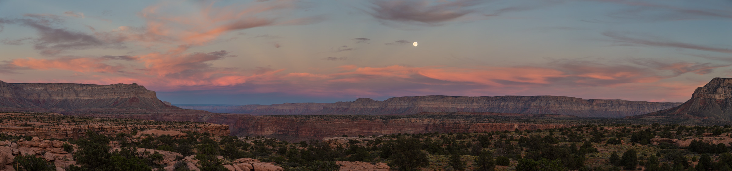
It was a good decision. The view was really great from camp, and the light in the distance was nice.

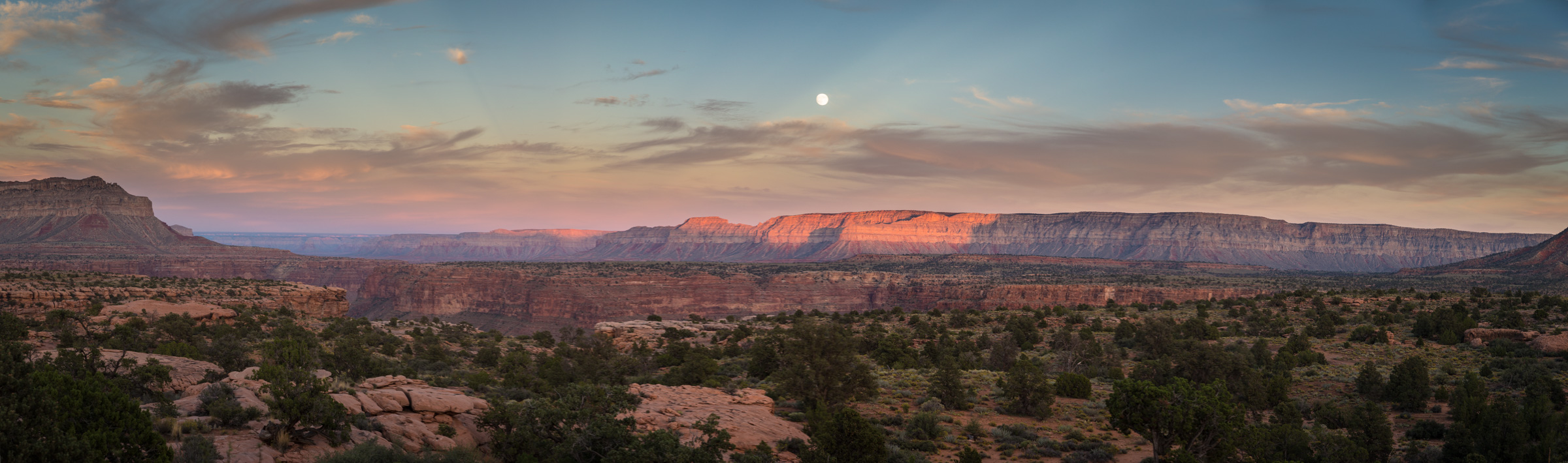
It was the day before the Harvest Moon. Also a super moon, I've been told. One that would experience a lunar eclipse the following night. Not tonight though, instead I got to watch that big thing take flight over the cliffs of the south rim.

I took too many pictures of that sunset.


I had thought about going back to Toroweap for the sunset, but I'm glad I stayed in camp this night. Don't get me wrong, it would have been epic there too, but it was nice to see a different view too.
The next morning I got up with the sun and hit the road. I saw a red tailed hawk just sitting on a rock, and soon after I nearly hit a big healthy coyote. I made it from my campsite at Tuweep back to Salt Lake in just under 6 hours. Not bad. Why haven't I been here before again?

I was settled in at home when Audra told me we were going to see the super moon eclipse. After a little complaining, I had camera and tripod in hand and we were out watching it rise over the Wasatch. I have to admit, it was pretty cool. And a good way to wrap up the weekend. This trip to The Grand was a good taste. I get it now. And I will be back.


Featured image for home page:

A few years ago I came close. After seeing photos and video of the canyons within the canyon, I booked a permit to do a big backpack-canyoneering loop there, but my knee was toast by the time the dates rolled around and hiking down thousands of feet to just hike right back up seemed like a terrible idea. Back to the 'maybe someday' pile you go, Grand Canyon.
Out of the blue this fall, I decided it was time. Or maybe it wasn't totally out of the blue. First, I read The Emerald Mile. An excellent book that is technically about the fastest float down the Grand, but really about so much more than that. Grand Canyon, Glen Canyon, conservation, breaching dams, theoretical walls of water 500 feet high, and the dams that almost got built in the Grand. That book really worked it's way into my psyche. The urgency to experience the Grand was now there. Maybe not for a year or two, or three, but it was there. Especially toward the river. And then something else, and I know it sounds silly, but a song by a band called Puscifer kind of pushed me over the edge. Puscifer is Maynard James Keenan's little pet project. The guy from Tool and A Perfect Circle for those familiar with his work. He's been living down in Jerome, Arizona making wine for quite some time now and it seems the desert has infiltrated his soul much like it has mine. MJK has had the strongest influence on me when it comes to music, so it feels good to see someone I admire so much fall in love with the same landscape I hold so dear and start incorporating it into their art. Anyway, that song is called Grand Canyon and the video for it is fabulous in my opinion. A time lapse from sunset to sunrise and into the day, all in and around the Grand Canyon, and even into Glen Canyon. It certainly won't be to everyone's musical tastes, but I'll post it here anyway. At the very least, the visuals are excellent.
Sorry, I'm getting long winded here, and this isn't nearly as entertaining as when someone like @slc_dan starts busting out paragraphs. So back to the point... It was time to finally see this big ditch everyone won't shut up about. So when I found out I needed to make a business trip to St. George, I started planning. I figured I'd just go out after work on Friday and go see the touristy overlooks. Just to finally be able to say I've seen the damn thing. So I posted a thread and asked for your advice from BCP. Great advice. The greatest of which, was to skip the traditional north rim area and head for Toroweap. A 60-mile long dead-end dirt road notorious for eating tires did not initially sound like something I wanted to do solo, but then @Artemus finished a post with three words, and I was sold...
Toroweap, Toroweap, Toroweap.
I finished up working in St. George midday on Friday. It was hot for mid-September. Real hot. Before I left pavement, I stopped in Hildale, Utah. I've always been compelled to get through Hildale/Colorado City as fast as possible, but I wanted to drive through town and take a look at the aftermath from the deadly floods that had swept through a little more than a week earlier. 13 dead in this flood in Hildale, 7 more in Zion and I believe one more near Hurricane. Still hard to believe a month later. All from one storm. The railing that used to span the edge of the sidewalk looked like nothing more than thin copper wires wrapped in debris. Huge piles of sand around. I stopped just for a moment, took a few photos and was on my way. I didn't want to be disrespectful, but I wanted to see this.
I found my way back to the highway and to an unsigned dirt road that I hoped would lead me to the Grand Canyon, 60 miles south. It felt weird doing this alone. Exhilarating.
I had my GPS, but this was the first thing along the road that confirmed I was headed in the right direction.
I made a stop along the way to check out an archaeological site known as Paiute Cave. The spur road that led me to it was rough and totally petered out as I arrived at the cave. You would never know it was here until you're pretty much on top of it.
Looking down into the cave. It's just a collapsed lava tube.
But it has some very interesting rock art hiding down there.
I took very careful steps as I scrambled the steep and loose rock down into the cave. Not the place to take a fall by myself. At one point I looked up to see this little bird's nest on the opposite wall.
The cave was deep, dark and cool. I should have brought my tripod, but I didn't feel like climbing back out and back in, so these are handheld at high ISO. The colors look like they were done yesterday.
Looking back out from the bottom of the cave.
Onward to Toroweap. I thought about heading over to Nampaweap en route, but I decided I'd better get out to the canyon rim and see Nampaweap the next day or on my way out. The landscape certainly started looking a little more grand as I rolled through Grand Canyon Parashant National Monument.
After entering the park, I found myself approaching a stop sign. I pulled up and a nice volunteer named Stewart came out and greeted me. I was at the Tuweep Ranger Station. He told me about the hikes, the campground and sent me on my way.
I stopped to admire this old grader just past the station.
The road got pretty bumpy in a few spots for the last few miles, but nothing bad. In fact, I saw a 90-something Toyota Tercel parked less than a mile from the overlook. Now that's pretty gutsy. Or something. I had the overlook to myself when I arrived, so I grabbed my camera and walked to the edge. The anticipation was huge. I felt like if I didn't look over that edge and see unicorns shitting rainbows, then I might just be disappointed in all of this. The view was good. Okay, it was really good. So I climbed down to the next layer where I could really see the river well. A bit dazed, I leaned back away from the edge and took some photos. And more photos. Not sure what to think of this. Wow. Just wow. I got down on my hands and knees and crawled. No, I didn't crawl, I wormed my way out until my head was suspended 3,000 feet above the Colorado River. And there they were... unicorns, pooping rainbows all over the f-ing place. Well done, Grand Canyon, well done. Not over hyped at all. This was truly one of the most amazing things I've ever seen.
I walked around a bit and took it in before I decided I better get up to the campground and get a spot. Maybe come back for sunset in a couple hours. There were three groups in the 10-site campground when I arrived. Stewart told me there would be only one other group. Oh well, I was prepared for full. I took site #8 and I was very happy with my choice. I unloaded some gear, made a cocktail and read a couple chapters of Desert Solitaire as the light turned golden. After my second cocktail, I realized I may have made them a bit strong and that I was very sleepy from an early start that day. The temptation struck to skip the overlook tonight and stay in camp. There were few clouds in the sky, I thought. I didn't come all this way to sit in camp though. Back to Toroweap.
I started with the view up canyon. Doing the self portrait near the edge was a bit frightening, but if you're going to fall off a cliff taking a photo, what better cliff than this?
I eventually settled in further down canyon where I could see Lava Falls. The views were so tremendous. I didn't even know where to point my camera so I just set it up for a time lapse and sat and took it in.
Cell phone shot as the time lapse was going.
Another cell phone shot. See the 5 or 6 rafts parked on the point down there. 3,000 feet is so big.
A shot from the time lapse as the clouds lit up.
And finally, the time lapse itself, along with a couple of clips looking over the edge and one of the sunset from camp on the second night.
That night the moon was nearly full. I sat alone and read for a while before sacking out. The next morning I cooked bacon and eggs before heading out for Nampaweap to see more rock art.
Nampaweap is by no means close to Toroweap. I think it was like 20 some odd miles one-way, some of which on pretty rough roads, but I didn't have anything to do that day, so why not. After getting to the trailhead, it was a short 2/3 mile hike to this site where there are hundreds(?) of petroglyphs chipped into basalt boulders lining the side of the canyon.
You think you see them, then you take a step or two and there are more and more. It's a very impressive site.
I ran into an archaeologist for the monument on my way in. He was friendly and we talked for a moment. Maybe it's because I was re-reading Desert Solitaire, but he was a spitting image of Ed Abbey from 1957. NPS truck, cowboy hat, beard, jeans, checkered shirt. Real nice guy.
On the way back out I ran into him again. He had seen my truck and asked about Backcountry Post. I believe he was concerned about these sites getting published. I assured him that no directions to rock art sites would ever come from me or become public on BCP. I think what he really meant was 'just don't post ANYTHING on the internet', but come on... there are signs on the dirt roads pointing to this place, and info all over the place. It is marked on the NPS maps. There are interpretive signs at the trailhead. If people want to seek it out, they will, and fortunately, they have to go to a pretty remote place to do that. Coincidentally, I also got a talking to from Stewart about not posting things on the internet after he got a better look at my truck. Time to ditch the BCP vanity plates and swap my big BCP sticker out for a normal sized one, I suppose. Parks are for people, just not ones who see them on the internet? But then again, it did feel kind of like how Abbey describes Arches in 1957 out here.
After Nampaweap it was back to the rim, but not before passing back by the Greater Tuweep Metro Area, aka the ranger station.
I wanted to watch some rafts run Lava Falls Rapid so I headed back out to Toroweap. These yellow flowers were blooming along the road.
I got there just in time to see a group of rafts run Lava, but without binoculars, or rather, a telescope, all I could really see were tiny spots. This cropped photo shows it better than I could even see through my 'long' lens. See 'em? A few lined up and a few running it.
It was hot out there that afternoon. I hid under a little juniper and watched some ravens ride the currents before heading back to camp.
I went back to camp to find just what I was hoping for; lots of shade to sit and read with a damn fine view. It was the chapter in Desert Solitaire where they're floating down Glen Canyon while the dam is being build. The part where they finally find Rainbow Bridge canyon. Where he is talking about how he should have forced Newcomb to come with, shoes or no shoes. How could he miss that opportunity?! That's when I looked up and realized I ought to get off my ass and go for a nice walk. I'd noticed on the topo map that there was something called 'Saddle Horse Spring' not too far from my camp. It looked like it was right on the rim of the canyon, but how could that be? I tossed some water in a pack and started wandering east toward the rim. I took great care to avoid the plentiful cryptobiotic soil. For as much use as the campground gets, it seemed that few wondered out this way. Or maybe they were also careful.
An old trough as I neared the point where I hoped to find the spring.
And 20 feet away I found a pipe dangling in mid air. Upon further inspection, it continued down into a small side canyon, held up by old sticks tied together with metal wire, gently swooping downward and outward toward the abyss. Well I have to see where this goes...
I didn't expect that. It went to the edge and hit a 90 and went straight down!
I poked around at the edge and all I could see is that it went down to a ledge just below. And that I could walk down there. On I go.
The view down into Saddle Horse Canyon.
Once down to the next ledge, I found that the pipe turned again and continued along the ledge. At one point passing a spot that had rocks stacked up to give it a little less pucker factor.
I followed the pipe around another corner until I found Saddle Horse Spring.
I was stunned. There just below the rim of the canon was a perfect spring. Held back by no more than a 2 foot strip of earth covered in grasses. A small trickle rolled down and over the edge while water gurgled in through a hanging garden in the back.
Tadpoles were swimming everywhere. Spiders lurked in the grass waiting to catch bugs that came in for a drink. Little red flowers leaned in. The water was probably 2 feet deep in the middle, 6 feet wide and at least 12-15 feet end to end. I wanted to strip down and jump in and soak it in through every pore. As Abbey said, "If the water is scummed with algae, crawling with worms, grubs, larvae, spiders and liver flukes, be reassured, drink hearty, you'll get nothing worse than dysentery".
But this was not a place to swim. It would have been fantastic, but it was so beautiful and so delicate. My presence in there would have made a bloody mess. Instead, I took off my shirt, crawled out to the edge and plunged my face in, sucking in as much of that delicious water as I could. I splashed a bit on my chest and sat there with my mind blown, and just took in the view.
I didn't want to leave, but eventually I packed up and continued exploring. Just following the rim.
Not too far from the trough, I found this old relic. Any ideas?
Eventually I got cut off by a side canyon and had to start angling back toward the campground. I connected with the Saddle Horse Loop trail where I thought about taking it, but the clouds had moved in and blocked out the sun. Back to camp.
It was a good decision. The view was really great from camp, and the light in the distance was nice.
It was the day before the Harvest Moon. Also a super moon, I've been told. One that would experience a lunar eclipse the following night. Not tonight though, instead I got to watch that big thing take flight over the cliffs of the south rim.
I took too many pictures of that sunset.
I had thought about going back to Toroweap for the sunset, but I'm glad I stayed in camp this night. Don't get me wrong, it would have been epic there too, but it was nice to see a different view too.
The next morning I got up with the sun and hit the road. I saw a red tailed hawk just sitting on a rock, and soon after I nearly hit a big healthy coyote. I made it from my campsite at Tuweep back to Salt Lake in just under 6 hours. Not bad. Why haven't I been here before again?
I was settled in at home when Audra told me we were going to see the super moon eclipse. After a little complaining, I had camera and tripod in hand and we were out watching it rise over the Wasatch. I have to admit, it was pretty cool. And a good way to wrap up the weekend. This trip to The Grand was a good taste. I get it now. And I will be back.
Featured image for home page:

")