The Maze Overlook and Jasper Ridge

#1 is the one with more trees and less views.
#2 is more open. Here is a picture of my Jeep in #2. #1 is located to the left from my Jeep.
View attachment 42527

Thank you. I've spent many a night at #2 long before there was a #1. I prefer a few more trees in July but I have a hunch that I will have both sites.
 
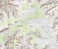
Are there any opportunities to traverse a slightly southern route off the 4WD between Standing Rock and Doll House? For example, if a backpacking group wanted to camp somewhere near approximately (say 38.1654,-109.9741) on their way back to the Doll House?
 
It looks like it's still on current topo maps. Walking off-trail in that area can be difficult with the crazy amounts of huge cryptobiotic soil that you must avoid crushing. The more I think about it, walking that old road could be an option, but the best would be to keep your footprints in the bottoms of minor drainages to keep the impact down. It looks like much of that road follows a more significant drainage.

upload_2017-2-6_17-23-35.png
 
Yeah, we'll definitely do our best to protect the cryptobiotic soil. Yeah, I was wondering if even further south was an option than that route...
 
Last edited:
Are there any opportunities to traverse a slightly southern route off the 4WD between Standing Rock and Doll House? For example, if a backpacking group wanted to camp somewhere near approximately (say 38.1654,-109.9741) on their way back to the Doll House?
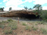
Yes, there is a closed road that cuts off to the right just past Standing Rock. There is a nice Cave along the way that used to be an official campsite up until 1981. They don't want you to camp there now for some silly reason.The Cave.JPG
 
Nice. Will see if I can track down a map that shows it.

The Standing Rock end of that road is quite visible and marked to this day. The entire road is easy to follow except for one large white rock ledge close to Standing Rock. Your tendency would be to cut to the right on this open rock but cut to the left and you will see where the road dropped off of the rock. It is then that you will pass by the cave on your left. The rest of the road is overgrown with grass but quite visible with no cryptobiotic sections. The slab above the cave has lots of jasper and chert that has been worked.
 
Ah, so anywhere on that closed road (sans the cave) should be permissible for camping - presuming we had adequate water already?
 
Are there any opportunities to traverse a slightly southern route off the 4WD between Standing Rock and Doll House? For example, if a backpacking group wanted to camp somewhere near approximately (say 38.1654,-109.9741) on their way back to the Doll House?
The cave I mentioned is N 37 57 57.2 W109 43 1.1
 
Ah, so anywhere on that closed road (sans the cave) should be permissible for camping - presuming we had adequate water already?

I believe so. If there was inclement weather I would not hesitate to stay in the cave. I holed up in there for three straight nights in May 1977.
 
@Nick - looks like Tex's Riverways shuttle schedule will keep us out in The Maze one extra day. If you had one extra day to spend on this adventure, what else would you have done? The Fins? A better view of Chocolate Drops? Water Canyon to Green River? something else?
 
It would be pretty cool to use South Fork Horse as an access point to/from The Maze canyons and tie in a walk through The Fins. That's probably what I would do, either on the front or back end.
 
It would be pretty cool to use South Fork Horse as an access point to/from The Maze canyons and tie in a walk through The Fins. That's probably what I would do, either on the front or back end.
Have you seen a route that ties them together? Not finding one easily (yet)
 
Have you seen a route that ties them together? Not finding one easily (yet)

Obviously you can head down the road and head in on the trail that starts near the mother and child. I imagine you could even cut off a good chunk of that looking at the topography. I do know of one possible route a bit west of Standing Rock. We started to scout it and we felt it would go but we didn't do it. It's far west of the springs though so it wouldn't be ideal.
 
@Nick - yeah, was hoping there was a 'secret' route from Standing Rock down past Tibbett Arch or Muffin Arch :)
 
Last edited:
there is a route into the easternmost canyon in the fins (Alice...the one that contains muffin). Can't remember exactly where but it's close to the very head of the canyon and goes out the east side.

That's the one I'm thinking of. We started down it just to check it out during a sunset walk from Standing Rock.
 

Don't like ads? Become a BCP Supporting Member and kiss them all goodbye. Click here for more info.

Back
Top