- Joined
- Dec 23, 2013
- Messages
- 4,378
I believe that I might be a bit of a complainer by nature, so this report will have some minor complaints throughout unfortunately. ")
First off, this trip around Shoshone Lake was supposed to be a nice relaxing family backpacking trip. Originally, Katie, Sheila and I were going to be the participants, but Katie started working a summer job at the library here in town, which meant she was no longer available to see the splendors of Yellowstone. BCP member Pringles also showed an interest in going, but she had to pull out of the trip the week before due to a board meeting that she had to sit in on (virtually) that conflicted with a couple of the days that we would be in the backcountry. So that just left Sheila and myself to enjoy Shoshone Lake and vicinity.
Our plans were to head up on Friday, the 23rd of July, and stay overnight at the Grant Village Campground, and then we would head into the backcountry on the morning of the 24th. Well, on Wednesday morning the 21st, I woke up not feeling quite right. As the day progressed, I still felt kind of funky, but I wasn't sure if it was just the heat of the day here in Salt Lake, or if I was actually coming down with something. On Thursday morning, I could definitively tell that I wasn't feeling well. So after getting up, I took a COVID test to see if I had the virus. The test came back "negative." I continued to feel crummy throughout the day, and Sheila asked me if perhaps we should cancel the trip. I told her that I'd see how I felt in the morning and make a decision.
I woke up Friday morning and thought that I felt a little bit better and that we should go. I knew that I still had one more day before backpacking in to the backcountry, so I was slightly optimistic that I could pull this off. Now @Bob had invited us to swing by and say "Hi" on our way to the Park, so I again took another COVID test Friday morning, and once again it returned a negative result.
Now I talked a little bit earlier about complaining. Well, let me start off by complaining about myself. We packed all our gear up and hit the road just before 8:00 am, and just before we reached Malad, Idaho, I realized that I had forgotten both of our cans of bear spray, sitting on the kitchen counter! So we stopped in Pocatello at the Sportsman's Warehouse and purchased a coupe cans of new spray.
  Now, you'd think the first thing that one would remember when planning a backpacking trip to Yellowstone, it would be bear spray. Man, what a nincompoop I am! That turned out to be an expensive forget.
As we got closer to Island Park, Bob let us know that the Forest Service was having a Wildfire Awareness Event along Highway 20 at the Island Park Ranger Station for the Targhee National Forest, and if we were interested, we could stop and have a burger or a hotdog for lunch. So we stopped in an had a bite to eat and visited the information booths that they had set up for the public. When we first arrived, they had Smokey Bear out front waving at folks passing by, and I wanted to get my picture taken with him. Unfortunately, by the time we finished our meal, Smokey had left. So I did the next best thing instead.


Sheila, checking out the info booths

Not the "Real Deal," but close.
After lunch, we headed on down the road and stopped in to see Bob. We chatted for around thirty minutes, mostly talking about our upcoming Teton Wilderness trip, after which we said our goodbyes and headed to West Yellowstone to pick up our official backcountry permit.
After getting our permit, it was on to Grant Village for the night.
We arrived at Grant Village and checked in. We ended up in Loop J sight 367. So off we went to set up our tent and have some dinner.

Site 367

Our tent.
After getting everything set up, I began to feel worse, and ended up turning in for the night around eight o'clock. This is where complaint number two arises. The Grant Village Campground has a policy that quiet hours begin at 10:00 pm and last through 6:00 am the following morning. That seems pretty straight forward to me, but obviously not to everyone. Our next door neighbors, a couple of what appeared to be mid-twenty type young men, decided that ten o'clock was just when the fun begins. They had two others from somewhere else in the loop join them for beer and loud conversation, along with deep guttural laughter. This went on until 1:15 am the next morning. I bring earplugs for just such an occasion, but with my sinuses feeling like they were going to explode every time I tried to lie down, I just couldn't handle it with my ears plugged too. I was miserable. After they finally retired to their tent for the evening, I came this close (my thumb and index finger are roughly 1/16 on an inch apart) to unloading my newly acquired bear spray into their tent. It seemed as though I might have to pull the plug on our trip after all. I did eventually fall asleep, and woke up the next morning around eight.

Our breakfast at Grant Village.
I told Sheila that I felt better than last night and that I thought I could make it to our first campsite on the lake. We packed up our gear and drove to the DeLacy Creek Trailhead. I knew at this point that Sheila could just tip, or push me over and roll me to the lake if necessary. We only had approximately 3.5 miles to go to reach 8S2 anyway. If things got worse, we could always hike right back out the following day.
Here is our story:
Day 1 - Delacy Creek Trailhead to campsite 8S2 - 3.5 miles.
The trailhead was busy when we arrived, as the hike down to Shoshone Lake is a popular day hike. This meant that on our way to the lake, we ran into a lot of hikers. As a matter of fact, the Walker Family had about thirty family members hiking down to the lake. It was definitely a busy stretch of trail that day.

The DeLacy Creek Trailhead

The map at the info sign that shows our intended lollipop loop

@TractorDoc, @wsp_scott and I were the last to see this gentleman alive last year when
we stayed at campsite 8R5 on the lake.

DeLacy Creek

The original Howard Eaton Trail - one of the highlights of the trip for me.

I walked down the Howard Eaton for a little ways. The mosquitoes got so bad though
that I had to make a hasty retreat.

The beautiful Delacy Creek Meadows

The DeLacy Creek Trail

Geese in the meadow

Monkshood along the trail

First glimpse of Shoshone Lake

Lily pad filled DeLacy Creek

Arriving at the trail junction sign just before the lake

Shoshone Lake

Heading west to campsite 8S2

Arriving at camp

Our tent site at 8S2

The Red Mountains and Mount Sheridan across the lake

Dinner for night one.
Day 2 - Campsite 8S2 to Campsite 8R5 - approximately 8.0 miles
I woke up still not feeling well. I knew day two would be the longest day for us, and it took me a good portion of the day to cover those eight miles. I took plenty of rest breaks along the way between the campsites. At first, the trail follows the shoreline of the lake, but it eventually leaves the lake and heads through the Cement Hills on the north side of the lake. We only returned to the lake when we reached campsite 8R5.
Originally, we thought we might take in the geyser basin that evening, but I just didn't feel up to it, so we saved it for the next day.
Once again after setting up camp and eating dinner I called it a day.

Morning of day 2 on Shoshone Lake

These canoers were going to attempt a day hike to Pocket Lake before heading on to their next campsite

Getting close to leaving the lake for a time

Crossing a stream before leaving the lake

Making our way through the Cement Hills

I believe this sign marks the trail that heads south to the Cove Patrol Cabin on the north
side of Shoshone Lake

Arriving at the trail to our night's campsite

Our tent site at 8R5

Night two's dinner

Lake shot from 8R5

Our setup at the feeding area

One last lake shot, looking east, before calling it a day.
Day 3 - Campsite 8R5 to Campsite 8M2 on Moss Creek - 5.1 miles
When I awoke on day three, I could tell that I was feeling better than the previous two days, but I was still nowhere near 100%.
Today's route would take us through the Shoshone Geyser Basin, where we dropped our packs for awhile and explored the thermal area a bit. We also got to experience the marshy west side of Shoshone Lake. While making our way along the west side, we encountered something seismic! Also, it is time for complaint number three: The trail along this section is in bad shape. The footbridges across streams have collapsed, and have yet to be replaced. Charging for people to camp overnight in the backcountry ought to equate to getting these things fixed. A pet peeve of mine I guess.
After leaving the west end of the lake, we had a steep climb up and over the ridge that then drops down to Moose Creek. I had never camped at either site on Moose Creek, so I was excited to stay the night at someplace new.
Another exciting thing about day three was that we would have the opportunity to meet a number of CDT hikers because this stretch of trail is part of the CDT. One couple from Holland was particularly memorable, as they were very enthusiastic. They were very excited to eat breakfast at Old Faithful the next morning. Their cheerfulness was very contagious and I'm sure it helped me reach our camp on Moose Creek. Another gentlemen that we met was averaging 25 miles a day. Bravo! I told him that I was impressed and wished him luck on finishing the trail.

A look towards geyser basin in the morning of day 3. The basin is behind the hill directly ahead in the image

A couple of canoes and two foot peddled craft leaving the geyser basin

Arriving at a trail junction

Entering the geyser basin

Thermal feature - @TractorDoc will have to name these for everyone.

Hot spring

Always worth a trip to see the geyser basin

Thermal feature and Shoshone Creek

Continuing on through the basin

A bubbler.

Sheila taking a picture

Hot spring

Another hot spring

Is this Minuteman @TractorDoc ?

I liked this one

A bubbler

Not sure, but maybe Union Geyser?

West end of Shoshone Lake, looking towards the narrows

Old sicko crossing Shoshone Creek

And begins the marshy section of our day

Collapsed footbridge made for an interesting big step.

Yellow pond-lily

I feel the earth move under my feet, I feel the sky tumblin' down! A tumbin' down! A Seismic Event! Did you feel a disturbance in
the Force @Rockskipper? I'm not sure how the camera survived this shot. What a joy to run into a fellow kilter on the trail.

The marshy west side of the lake made for some good dragonfly opportunities.

Another one

And one last one

Cold Mountain Creek on its way to the lake

Back at the lake, before starting our climb up and over the ridge to Moose Creek

Gaining some elevation off the lake

An old Yellowstone trail marker

Almost at the top of the ridge. This hill tired me out.

Arriving at 8M2 - Moose Creek Meadows

Moose Creek

Moose Creek Meadows

More Moose Creek

Tent at 8M2

Moose tracks on Moose Creek.
Day 4 - Campsite 8M2 to Campsite 8S0 - 5.2 Miles
I felt around 90% when I awoke on day four. It was good to be getting better, and to have increased energy levels, and also have another short day. I did begin to cough a lot on this day though. So day four offered up a couple of water crossings: one being Moose Creek, and the second being the Lewis River at the outlet of Shoshone Lake. At the ford of Moose Creek, I lost my little green, tear-dropped thermometer, and I had to take some time to look around for it, but I finally found it thank goodness.
I was a bit surprised after we left 8M2, thinking that we would follow Moose Creek all the way to the crossing. But the trail actually leaves the creek and climbs above it, and really doesn't return to the creek until the ford. After the ford, we climbed another ridge, dropped down to a marshy meadow, and then up another ridge before finally switchbacking down to the Shoshone Lake outlet. After crossing the outlet, it was a short beach walk to reach out campsite 8S0.
Gripe number four: Campsite 8S0 is actually one of two campsites in the Park that allow two parties to reserve the site. One, 8S1, is for paddlers, and 8S0 is for backpackers. The site has two numbers, but they are the same location. Since I had reserved 8S0 in the raffle, and 8S1 is reserved for boaters, I thought the only chance of meeting people would be of the canoeing and kayaking type. Now back in the old days, if 8S1 hadn't been reserved by 4:00 pm that same day, the Backcountry Office could release it to another backpacking party.
Well, once we arrived at camp, we did our usual routine - set up camp, hung our food, and then headed over to check out the patrol cabin located just to the east of the campsite. After dinner, we set up our camp chairs on the shore of the lake and just kicked back and enjoyed the scenery. We crashed about 8:30 pm. Along about nine o'clock I can hear a tinker, tinker, tinker off in the distance, but I can tell it is getting closer. Eventually a bear bell wearing couple shows up and pitches their tent right next to ours. I can hear them talking, and the man says that they covered 30.5 miles today. So I came to the conclusion that they must be CDT hikers too. A few minutes later another couple showed up and pitched their tent at a site that was furthest away from out tent. So the thought occurred to me that they probably hadn't reserved a place at 8S1, just showed up late and stayed. Perhaps I'm wrong. I tried to balance the impressive goal that they were accomplishing with the not following the rules part of it - at least in Yellowstone.

Moose Creek in the morning

A couple artic fritillaries enjoying some mountain dandelions

Fording Moose Creek

My teardrop thermometer that I temporarily lost.

Lots of new growth along this stretch, with Shoshone Lake visible again

The marshy meadow that we dropped down to

This is the old trail down to the outlet ford. I tried to get Sheila to take this one, but
she was a no-go.

Looking down on the outlet of Shoshone Lake

The other end of the original trail to the outlet ford

Arriving at the outlet

Crossing the outlet

The DeLacy Creek Drainage across the lake

Small section of beach hiking to reach camp

Arrived

Tent site at 8S0

The essentials.

The Outlet Patrol Cabin - I can't believe that these are not manned fulltime.
Complaint #5!

Checking out our map.

Dinner for night four

Tomorrow's trail

Arnica going to seed

Looks cold, but actually was very pleasant

The life of luxury.

Sunset on Shoshone
Day 5 - Campsite 8S0 to the DeLacy Creek Trailhead - 7.2 Miles
As our tent was right on the trail that led to the cooking area and the bear pole, I could hear one of the people from the second arrivals head down and then back to their tent. We awoke at 6:00 am the next morning so that we could get an early start, since we had to hike out and then drive down to Jackson for the evening. So while we are taking down our tent, the lady from the couple that had arrived the latest got out of their tent and went and got their food bag off of the bear pole and then returned to their tent. The couple that had done the 30.5 miles the previous day hadn't hung their food, and they began eating in their tent as we finished up taking down our tent. This is a no-no in grizzly country. So not only did they potentially endanger their lives, they also endangered ours, and perhaps anyone else who comes along and uses that campsite. Sheila and I headed down to the food area and ate our oatmeal. When we returned, both parties had made haste and were gone.
The east side trail that runs along Shoshone Lake took me a bit by surprise - certainly not hard to do. It was a very up and down trail, down to the lake then back up to the top of the ridge, taking us at first through burn and new growth from the '88 fires, then through some old growth the rest of the way for the most part. When the trail did level out, we had to hike along some pea to nickel sized rocks along the beach which made for a good workout. The trail was very narrow in places, and at least twice, it looked as if the trail would slide down the steep hillside towards the lake. This trail appeared to be seldom used except by the occasional elk or two. I commented to Sheila that a mule wouldn't be stupid enough to take this trail. And the mosquitoes! The mosquitoes were killers along this stretch! 4.2 miles of being eaten alive. While the trail may have been for elk, mosquitoes, dogbane and lupine, I'm not quite sure it was for me. I felt like I was chasing hellhounds @Rockskipper! Or maybe it was just the illness getting to me. By the way, I was feeling about 98% on this last day, with mostly some coughing and phlegm issues to deal with.
So as we arrived at the junction with the DeLacy Creek Trail, we met a retired police officer who was bringing his grandson into the Yellowstone backcountry for the first time. His grandson was fishing in the lake as we chatted. They were essentially doing our route in reverse. He also mentioned that his wife was going to join them and that she was still coming down the DeLacy Creek Trail. He then mention that she was losing her sight and required a service dog to guide her. What? Service dog? I didn't think that Yellowstone allowed dogs into the backcountry? They tend not to play well with the wildlife. I looked it up when I got home and sure enough you can get a permit to take a service dog into the Yellowstone backcountry. Who knew?
We said our goodbyes to the two gentlemen and began the last stretch back to the trailhead. About twenty minutes from the lake we ran into the lady with the dog and chatted for a few minutes. Once again this was very inspirational to me. They were heading all the way to Moss Creek - 11 miles roughly, and she would be going on that trail on the east side of the lake. If they actually made it to Moss Creek, then my hats off to her. Quite an accomplishment - on par with the 30.5 mile day in my book.

Some fog lifting off the lake in the morning

Heading through the '88 burn

Some nice views up above the lake - looking towards the narrows

New growth as thick as dog's hair

The narrows

Time for some more beach hiking

The marsh on the east side of Shoshone Lake

Almost to the end of the beach

Arriving back at the DeLacy Creek Trail junction

DeLacy Creek

The lady with the service dog

Hey, I found a penny. This must be my lucky day!

A pale swallowtail

Back at the trailhead

And what is this? A note from @The Trout Whisperer!
So we packed up our gear and headed out to Jackson, stopping at Grant Village Campground to see @The Trout Whisperer. He turned out not to be at his site, so we continued on to Jackson, stopping at the Grand Teton Visitors Center on our way. When we arrived in Jackson, we checked into our motel, cleaned up a bit and went out for some Tex-Mex at the Merry Piglets. After dinner I had to make my annual pilgrimage to Moos for a Oreo malt with dark malt. Delicious!

I just loved this bus, parked in loop G at the Grant Village Campground on our way to see if @The Trout Whisperer was around.

I had two chicken spinach enchiladas.

While Sheila had two chili rellenos. Both meals were good, but I think Sheila's was a tad bit better.


Of course, every time I see the above two images I wonder why me and @Rockskipper aren't paddling down
the mighty Mississip?

Pure Heaven!
Well, it was an interesting trip to say the least. I was a bit disappointed that we didn't get to see any large wildlife while we were in the backcountry. On the other hand, the temperatures were perfect, with mid to high seventies in the day, and low to mid-forties at night. And I do know this, I'd rather be sick in Yellowstone than sick in Salt Lake.
The End.
First off, this trip around Shoshone Lake was supposed to be a nice relaxing family backpacking trip. Originally, Katie, Sheila and I were going to be the participants, but Katie started working a summer job at the library here in town, which meant she was no longer available to see the splendors of Yellowstone. BCP member Pringles also showed an interest in going, but she had to pull out of the trip the week before due to a board meeting that she had to sit in on (virtually) that conflicted with a couple of the days that we would be in the backcountry. So that just left Sheila and myself to enjoy Shoshone Lake and vicinity.
Our plans were to head up on Friday, the 23rd of July, and stay overnight at the Grant Village Campground, and then we would head into the backcountry on the morning of the 24th. Well, on Wednesday morning the 21st, I woke up not feeling quite right. As the day progressed, I still felt kind of funky, but I wasn't sure if it was just the heat of the day here in Salt Lake, or if I was actually coming down with something. On Thursday morning, I could definitively tell that I wasn't feeling well. So after getting up, I took a COVID test to see if I had the virus. The test came back "negative." I continued to feel crummy throughout the day, and Sheila asked me if perhaps we should cancel the trip. I told her that I'd see how I felt in the morning and make a decision.
I woke up Friday morning and thought that I felt a little bit better and that we should go. I knew that I still had one more day before backpacking in to the backcountry, so I was slightly optimistic that I could pull this off. Now @Bob had invited us to swing by and say "Hi" on our way to the Park, so I again took another COVID test Friday morning, and once again it returned a negative result.
Now I talked a little bit earlier about complaining. Well, let me start off by complaining about myself.
We packed all our gear up and hit the road just before 8:00 am, and just before we reached Malad, Idaho, I realized that I had forgotten both of our cans of bear spray, sitting on the kitchen counter! So we stopped in Pocatello at the Sportsman's Warehouse and purchased a coupe cans of new spray. Now, you'd think the first thing that one would remember when planning a backpacking trip to Yellowstone, it would be bear spray. Man, what a nincompoop I am! That turned out to be an expensive forget.As we got closer to Island Park, Bob let us know that the Forest Service was having a Wildfire Awareness Event along Highway 20 at the Island Park Ranger Station for the Targhee National Forest, and if we were interested, we could stop and have a burger or a hotdog for lunch. So we stopped in an had a bite to eat and visited the information booths that they had set up for the public. When we first arrived, they had Smokey Bear out front waving at folks passing by, and I wanted to get my picture taken with him. Unfortunately, by the time we finished our meal, Smokey had left.
So I did the next best thing instead.Sheila, checking out the info booths
Not the "Real Deal," but close.
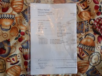
After lunch, we headed on down the road and stopped in to see Bob. We chatted for around thirty minutes, mostly talking about our upcoming Teton Wilderness trip, after which we said our goodbyes and headed to West Yellowstone to pick up our official backcountry permit.
After getting our permit, it was on to Grant Village for the night.
We arrived at Grant Village and checked in. We ended up in Loop J sight 367. So off we went to set up our tent and have some dinner.
Site 367
Our tent.
After getting everything set up, I began to feel worse, and ended up turning in for the night around eight o'clock. This is where complaint number two arises.
The Grant Village Campground has a policy that quiet hours begin at 10:00 pm and last through 6:00 am the following morning. That seems pretty straight forward to me, but obviously not to everyone. Our next door neighbors, a couple of what appeared to be mid-twenty type young men, decided that ten o'clock was just when the fun begins. They had two others from somewhere else in the loop join them for beer and loud conversation, along with deep guttural laughter. This went on until 1:15 am the next morning. I bring earplugs for just such an occasion, but with my sinuses feeling like they were going to explode every time I tried to lie down, I just couldn't handle it with my ears plugged too. I was miserable. After they finally retired to their tent for the evening, I came this close (my thumb and index finger are roughly 1/16 on an inch apart) to unloading my newly acquired bear spray into their tent. It seemed as though I might have to pull the plug on our trip after all. I did eventually fall asleep, and woke up the next morning around eight.Our breakfast at Grant Village.
I told Sheila that I felt better than last night and that I thought I could make it to our first campsite on the lake. We packed up our gear and drove to the DeLacy Creek Trailhead. I knew at this point that Sheila could just tip, or push me over and roll me to the lake if necessary. We only had approximately 3.5 miles to go to reach 8S2 anyway. If things got worse, we could always hike right back out the following day.
Here is our story:
Day 1 - Delacy Creek Trailhead to campsite 8S2 - 3.5 miles.
The trailhead was busy when we arrived, as the hike down to Shoshone Lake is a popular day hike. This meant that on our way to the lake, we ran into a lot of hikers. As a matter of fact, the Walker Family had about thirty family members hiking down to the lake. It was definitely a busy stretch of trail that day.
The DeLacy Creek Trailhead
The map at the info sign that shows our intended lollipop loop
@TractorDoc, @wsp_scott and I were the last to see this gentleman alive last year when
we stayed at campsite 8R5 on the lake.
DeLacy Creek
The original Howard Eaton Trail - one of the highlights of the trip for me.
I walked down the Howard Eaton for a little ways. The mosquitoes got so bad though
that I had to make a hasty retreat.
The beautiful Delacy Creek Meadows
The DeLacy Creek Trail
Geese in the meadow
Monkshood along the trail
First glimpse of Shoshone Lake
Lily pad filled DeLacy Creek
Arriving at the trail junction sign just before the lake
Shoshone Lake
Heading west to campsite 8S2
Arriving at camp
Our tent site at 8S2
The Red Mountains and Mount Sheridan across the lake
Dinner for night one.
Day 2 - Campsite 8S2 to Campsite 8R5 - approximately 8.0 miles
I woke up still not feeling well. I knew day two would be the longest day for us, and it took me a good portion of the day to cover those eight miles. I took plenty of rest breaks along the way between the campsites. At first, the trail follows the shoreline of the lake, but it eventually leaves the lake and heads through the Cement Hills on the north side of the lake. We only returned to the lake when we reached campsite 8R5.
Originally, we thought we might take in the geyser basin that evening, but I just didn't feel up to it, so we saved it for the next day.
Once again after setting up camp and eating dinner I called it a day.
Morning of day 2 on Shoshone Lake
These canoers were going to attempt a day hike to Pocket Lake before heading on to their next campsite
Getting close to leaving the lake for a time
Crossing a stream before leaving the lake
Making our way through the Cement Hills
I believe this sign marks the trail that heads south to the Cove Patrol Cabin on the north
side of Shoshone Lake
Arriving at the trail to our night's campsite
Our tent site at 8R5
Night two's dinner
Lake shot from 8R5
Our setup at the feeding area
One last lake shot, looking east, before calling it a day.
Day 3 - Campsite 8R5 to Campsite 8M2 on Moss Creek - 5.1 miles
When I awoke on day three, I could tell that I was feeling better than the previous two days, but I was still nowhere near 100%.
Today's route would take us through the Shoshone Geyser Basin, where we dropped our packs for awhile and explored the thermal area a bit. We also got to experience the marshy west side of Shoshone Lake. While making our way along the west side, we encountered something seismic!
Also, it is time for complaint number three: The trail along this section is in bad shape. The footbridges across streams have collapsed, and have yet to be replaced. Charging for people to camp overnight in the backcountry ought to equate to getting these things fixed. A pet peeve of mine I guess.After leaving the west end of the lake, we had a steep climb up and over the ridge that then drops down to Moose Creek. I had never camped at either site on Moose Creek, so I was excited to stay the night at someplace new.
Another exciting thing about day three was that we would have the opportunity to meet a number of CDT hikers because this stretch of trail is part of the CDT. One couple from Holland was particularly memorable, as they were very enthusiastic. They were very excited to eat breakfast at Old Faithful the next morning. Their cheerfulness was very contagious and I'm sure it helped me reach our camp on Moose Creek. Another gentlemen that we met was averaging 25 miles a day. Bravo! I told him that I was impressed and wished him luck on finishing the trail.
A look towards geyser basin in the morning of day 3. The basin is behind the hill directly ahead in the image
A couple of canoes and two foot peddled craft leaving the geyser basin
Arriving at a trail junction
Entering the geyser basin
Thermal feature - @TractorDoc will have to name these for everyone.
Hot spring
Always worth a trip to see the geyser basin
Thermal feature and Shoshone Creek
Continuing on through the basin
A bubbler.
Sheila taking a picture
Hot spring
Another hot spring
Is this Minuteman @TractorDoc ?
I liked this one
A bubbler
Not sure, but maybe Union Geyser?
West end of Shoshone Lake, looking towards the narrows
Old sicko crossing Shoshone Creek
And begins the marshy section of our day
Collapsed footbridge made for an interesting big step.
Yellow pond-lily
I feel the earth move under my feet, I feel the sky tumblin' down! A tumbin' down! A Seismic Event! Did you feel a disturbance in
the Force @Rockskipper? I'm not sure how the camera survived this shot.
What a joy to run into a fellow kilter on the trail.The marshy west side of the lake made for some good dragonfly opportunities.
Another one
And one last one
Cold Mountain Creek on its way to the lake
Back at the lake, before starting our climb up and over the ridge to Moose Creek
Gaining some elevation off the lake
An old Yellowstone trail marker
Almost at the top of the ridge. This hill tired me out.
Arriving at 8M2 - Moose Creek Meadows
Moose Creek
Moose Creek Meadows
More Moose Creek
Tent at 8M2
Moose tracks on Moose Creek.
Day 4 - Campsite 8M2 to Campsite 8S0 - 5.2 Miles
I felt around 90% when I awoke on day four. It was good to be getting better, and to have increased energy levels, and also have another short day. I did begin to cough a lot on this day though. So day four offered up a couple of water crossings: one being Moose Creek, and the second being the Lewis River at the outlet of Shoshone Lake. At the ford of Moose Creek, I lost my little green, tear-dropped thermometer, and I had to take some time to look around for it, but I finally found it thank goodness.
I was a bit surprised after we left 8M2, thinking that we would follow Moose Creek all the way to the crossing. But the trail actually leaves the creek and climbs above it, and really doesn't return to the creek until the ford. After the ford, we climbed another ridge, dropped down to a marshy meadow, and then up another ridge before finally switchbacking down to the Shoshone Lake outlet. After crossing the outlet, it was a short beach walk to reach out campsite 8S0.
Gripe number four: Campsite 8S0 is actually one of two campsites in the Park that allow two parties to reserve the site. One, 8S1, is for paddlers, and 8S0 is for backpackers. The site has two numbers, but they are the same location. Since I had reserved 8S0 in the raffle, and 8S1 is reserved for boaters, I thought the only chance of meeting people would be of the canoeing and kayaking type. Now back in the old days, if 8S1 hadn't been reserved by 4:00 pm that same day, the Backcountry Office could release it to another backpacking party.
Well, once we arrived at camp, we did our usual routine - set up camp, hung our food, and then headed over to check out the patrol cabin located just to the east of the campsite. After dinner, we set up our camp chairs on the shore of the lake and just kicked back and enjoyed the scenery. We crashed about 8:30 pm. Along about nine o'clock I can hear a tinker, tinker, tinker off in the distance, but I can tell it is getting closer. Eventually a bear bell wearing couple shows up and pitches their tent right next to ours. I can hear them talking, and the man says that they covered 30.5 miles today.
So I came to the conclusion that they must be CDT hikers too. A few minutes later another couple showed up and pitched their tent at a site that was furthest away from out tent. So the thought occurred to me that they probably hadn't reserved a place at 8S1, just showed up late and stayed. Perhaps I'm wrong. I tried to balance the impressive goal that they were accomplishing with the not following the rules part of it - at least in Yellowstone.Moose Creek in the morning
A couple artic fritillaries enjoying some mountain dandelions
Fording Moose Creek
My teardrop thermometer that I temporarily lost.
Lots of new growth along this stretch, with Shoshone Lake visible again
The marshy meadow that we dropped down to
This is the old trail down to the outlet ford. I tried to get Sheila to take this one, but
she was a no-go.
Looking down on the outlet of Shoshone Lake
The other end of the original trail to the outlet ford
Arriving at the outlet
Crossing the outlet
The DeLacy Creek Drainage across the lake
Small section of beach hiking to reach camp
Arrived
Tent site at 8S0
The essentials.
The Outlet Patrol Cabin - I can't believe that these are not manned fulltime.
Complaint #5!
Checking out our map.
Dinner for night four
Tomorrow's trail
Arnica going to seed
Looks cold, but actually was very pleasant
The life of luxury.
Sunset on Shoshone
Day 5 - Campsite 8S0 to the DeLacy Creek Trailhead - 7.2 Miles
As our tent was right on the trail that led to the cooking area and the bear pole, I could hear one of the people from the second arrivals head down and then back to their tent. We awoke at 6:00 am the next morning so that we could get an early start, since we had to hike out and then drive down to Jackson for the evening. So while we are taking down our tent, the lady from the couple that had arrived the latest got out of their tent and went and got their food bag off of the bear pole and then returned to their tent. The couple that had done the 30.5 miles the previous day hadn't hung their food, and they began eating in their tent as we finished up taking down our tent. This is a no-no in grizzly country. So not only did they potentially endanger their lives, they also endangered ours, and perhaps anyone else who comes along and uses that campsite. Sheila and I headed down to the food area and ate our oatmeal. When we returned, both parties had made haste and were gone.
The east side trail that runs along Shoshone Lake took me a bit by surprise - certainly not hard to do.
It was a very up and down trail, down to the lake then back up to the top of the ridge, taking us at first through burn and new growth from the '88 fires, then through some old growth the rest of the way for the most part. When the trail did level out, we had to hike along some pea to nickel sized rocks along the beach which made for a good workout. The trail was very narrow in places, and at least twice, it looked as if the trail would slide down the steep hillside towards the lake. This trail appeared to be seldom used except by the occasional elk or two. I commented to Sheila that a mule wouldn't be stupid enough to take this trail. And the mosquitoes! The mosquitoes were killers along this stretch! 4.2 miles of being eaten alive. While the trail may have been for elk, mosquitoes, dogbane and lupine, I'm not quite sure it was for me. I felt like I was chasing hellhounds @Rockskipper! Or maybe it was just the illness getting to me. By the way, I was feeling about 98% on this last day, with mostly some coughing and phlegm issues to deal with.So as we arrived at the junction with the DeLacy Creek Trail, we met a retired police officer who was bringing his grandson into the Yellowstone backcountry for the first time. His grandson was fishing in the lake as we chatted. They were essentially doing our route in reverse. He also mentioned that his wife was going to join them and that she was still coming down the DeLacy Creek Trail. He then mention that she was losing her sight and required a service dog to guide her. What? Service dog? I didn't think that Yellowstone allowed dogs into the backcountry? They tend not to play well with the wildlife. I looked it up when I got home and sure enough you can get a permit to take a service dog into the Yellowstone backcountry. Who knew?
We said our goodbyes to the two gentlemen and began the last stretch back to the trailhead. About twenty minutes from the lake we ran into the lady with the dog and chatted for a few minutes. Once again this was very inspirational to me. They were heading all the way to Moss Creek - 11 miles roughly, and she would be going on that trail on the east side of the lake. If they actually made it to Moss Creek, then my hats off to her. Quite an accomplishment - on par with the 30.5 mile day in my book.
Some fog lifting off the lake in the morning
Heading through the '88 burn
Some nice views up above the lake - looking towards the narrows
New growth as thick as dog's hair
The narrows
Time for some more beach hiking
The marsh on the east side of Shoshone Lake
Almost to the end of the beach
Arriving back at the DeLacy Creek Trail junction
DeLacy Creek
The lady with the service dog
Hey, I found a penny. This must be my lucky day!
A pale swallowtail
Back at the trailhead
And what is this? A note from @The Trout Whisperer!
So we packed up our gear and headed out to Jackson, stopping at Grant Village Campground to see @The Trout Whisperer. He turned out not to be at his site, so we continued on to Jackson, stopping at the Grand Teton Visitors Center on our way. When we arrived in Jackson, we checked into our motel, cleaned up a bit and went out for some Tex-Mex at the Merry Piglets. After dinner I had to make my annual pilgrimage to Moos for a Oreo malt with dark malt. Delicious!
I just loved this bus, parked in loop G at the Grant Village Campground on our way to see if @The Trout Whisperer was around.
I had two chicken spinach enchiladas.
While Sheila had two chili rellenos. Both meals were good, but I think Sheila's was a tad bit better.
Of course, every time I see the above two images I wonder why me and @Rockskipper aren't paddling down
the mighty Mississip?
Pure Heaven!
Well, it was an interesting trip to say the least. I was a bit disappointed that we didn't get to see any large wildlife while we were in the backcountry. On the other hand, the temperatures were perfect, with mid to high seventies in the day, and low to mid-forties at night. And I do know this, I'd rather be sick in Yellowstone than sick in Salt Lake.
The End.
Attachments
Last edited:
