NEW: Sentinel Satellite Imagery in Caltopo

Stickerbumper

Member
Joined
May 16, 2017
Messages
43
This is a total game changer when it comes to early season trip planning and I haven't seen anyone posting this yet, so I thought I'd share it.


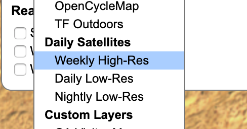
Basically, caltopo's daily updated low-res satellite imagery is now supplemented with high-res Sentinel imagery on a weekly basis. That means you can see real time snow coverage and estimate melt off rates since you can go back a few weeks (or years if you wish to) and compare, something you really couldn't do well before with the low-res images. For now the feature is free, but it might only be accessible to premium users in the future.
 
Last edited:
That really will be a game changer. Is it live for anyone yet? I looked for the option and can't find it.
 
Works like a champ. It's in the drop down menu when you add a layer. However, looking at the Beartooth plateau is making me sad.
 
That really will be a game changer. Is it live for anyone yet? I looked for the option and can't find it.

Maybe it's already behind the paywall? Can anyone who doesn't have premium confirm this works for them?
 
Me.

1) Stack new layer
2) Satellite images
3) Weekly Hi-res
4) Change opacity to whatever works for your needs.
 
79242

Interesting. I'm not seeing it as an option in layers.
 
BTW... this is HHUUUUGGGE!
 
Last edited:
Wow. This is an unbelievably wonderful tool. I'll pay for Caltopo if they make this a paid-only feature. I've been agonizing over where to go for a 3-nighter I've got planned with some friends who are flying out in under two weeks. This really makes it a lot easier.
 
Wow. This is an unbelievably wonderful tool. I'll pay for Caltopo if they make this a paid-only feature. I've been agonizing over where to go for a 3-nighter I've got planned with some friends who are flying out in under two weeks. This really makes it a lot easier.

Can't go wrong with the loop route I just did on Boulder over the weekend. As for paying for Caltopo, I've been paying for the mid-tier membership the last couple years, just to support the incredibly awesome collection of tools already made available there. This new addition looks awesome!
 
Wow. This is an unbelievably wonderful tool. I'll pay for Caltopo if they make this a paid-only feature. I've been agonizing over where to go for a 3-nighter I've got planned with some friends who are flying out in under two weeks. This really makes it a lot easier.

I believe that's the plan long term. They said on reddit it is pricey but they will leave it on as long as they can. I will absolutely pay for this kind of realtime data.
 
Wow. Glad this was pointed out. Looking at my upcoming route in Alaska, this is amazingly helpful. I feel a lot more confident after having looked it over on this new layer. Hard to get on the ground reports of snow/ice conditions up there. Will be checking this often over the next month to keep an eye on things.

I never feel like my caltopo subscription money is wasted.
 
Any way to tell what date the picture/imagery was taken?
Oh, I see, zoom out a little and date stamps show up. Next question.. any way to cycle back and forth to different dates as you can in Worldview?
 
Oh, I see, zoom out a little and date stamps show up. Next question.. any way to cycle back and forth to different dates as you can in Worldview?
OK answered that one myself also - I should poke around before asking the world. There is a dropdown to go back in time...
 

Similar threads

Back
Top