- Joined
- Aug 9, 2007
- Messages
- 12,967
A few weeks ago I would have laughed my ass off if you'd told me I'd be backpacking over Memorial Weekend this year. But with all the allergy drama over my knee replacement largely figured out, my recovery has sailed right along. Still too weak for a huge trip, but good for something shorter.
The weather forecast was dismal though. Week after week of extremely stormy weather, so much so as to actually cause flooding, like this and this in the preceding weeks. Something like Death Hollow (our original plan from over the winter) was out of the question, not only because of my knee but the weather. Even if it didn't flash, that would be pretty miserable to walk in 50-60 degree temps with rain drizzling down all day.
So instead we set out to a relatively unexplored area of the Grand Staircase-Escalante National Monument. I'm deliberately leaving the location vague, to keep it that way, but some of the landmarks are pretty easy to figure out if you're so inclined. The cool thing about our chosen route was that we would have no rivers or springs to draw from, instead we would rely on the rainwater to fill the tinajas.
Just as Nate showed up at my place to leave, a huge thunderstorm hit. Big enough that we were totally wondering what the hell we were thinking. We made a last minute stop at Dick's to pickup an easy-up type canopy. Backpacking was still the plan, but worst case we could sit under that and drink for the next 3 days and probably still have a pretty good time!
We picked up @slc_dan on the way out of town and made it to camp just before sunset and met up with @NateGeesaman who was just going to camp that night and hike a little with us the next day. A little disturbance blew through right at sunset, but then it turned out to be a nice night around the campfire. I didn't even bother setting up a tent, instead I just threw out a pad in the back of my truck like I usually do. Sometime in the middle of the night I felt rain on my face. I reached up and pulled the tonneau down. An hour later I realized my pad was still sticking out onto the tailgate and water was leaking into my bed. I folded it over and went into a slight fetal position and managed to stay mostly dry as the rain poured through the rest of the night and into the morning. It was kind of cool to still be out in it but protected enough to sleep.
We had a little break in the morning while we ate breakfast and packed our bags, but then right as we got to the trailhead, another wave of rain came. We waited it out for 10 minutes before saying screw it and heading off into the rain.
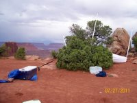
BCP was well represented at this trailhead.

Out came the rain coats, pack covers and ponchos. Walking through the sand was much easier and the drama all around was captivating.
There were a few moqui marbles here and there.

We didn't know a lot about our route. We knew there was sort of a way down somewhere around here, but that was about it.


A wrong turn led us through a precarious section.

The rain wasn't really coming down hard, just a light drizzle that kept the rocks soaked and the footing a bit on the slippery side. I loved the way everything looked wet.

We finally found the way down marked by a few cairns, the only cairns or trail of any kind we'd see until near the end of the hike 3 days later. The climb down was really tough for me. It was very steep, very loose, and very wet. If there's one thing my new knee still can't do, it's downhill. It took every bit of me to get down without taking a header. Oh, and the rain picked up here as well.

My place on this trip was almost always at the back of the group. I'm still moving slow, but more importantly, it made it so the more agile fellas in the group could scout ahead and warn me when it was a dead end or bad way to go. Very helpful to a guy with a bad knee. Thanks, guys. I was pleased to reach the bottom of the trail and find them all huddled up in this nice, dry alcove. We took a break and watched the rain come down.

The area just outside the alcove was like a flower garden. Everything blooming and just loving all the water they've gotten this month.

Nate G. had to turn around at that point to go to work at Hells Backbone Grill while the rest of us snacked and waited for the rain to lighten up a bit. And soon enough it did and we were walking down the canyon. But of course within 5 minutes it started raining even harder. Small waterfalls started to appear and the usually dry wash started to catch their flow.

And it rained and it rained. Never very hard but enough to soak everything. Little overhangs like this were nice when we found them.


Soon enough the entire wash bottom had gone from dry to flowing. We were hoping for a nice, big alcove to hide in but it wasn't happening. But this looked promising and there was a huge waterfall coming down right on top of it.


Here's a little video I shot with my phone as we headed up into the alcove.
The waterfall near our break spot was coming down right on top of this poor tree. Limbs were broken on the ground nearby.

The alcove wasn't big enough for more than a break, but for that it worked well. They're a little hard to see, but you can see at least 4 nice waterfalls on the opposite canyon wall.

Sage doesn't like being cold and wet.


Soon the rain lightened up and the waterfalls slowed. We put on our gear and set out and once again, the rain started up again. The main canyon drops into this slot but there was no way I was going in there with this weather. We found a nice bypass on the left LDC.

Nearing where this canyon meets the river. I'm not sure if there is a way down here or not, but at this point we changed course and worked our way through a pass that we weren't sure would go.

Rain slowed here and there but it never stopped. Happy flowers.


So many moqui marbles! Watch your step on these, sometimes they act like ball bearings.

The pass ended up going and we ended up right where we had hoped for camp 1. Right on the rim of the mighty Escalante. The rain finally stopped just after dark. The next morning I was so stoked to see the sun rising out the window of my tent.

A surprisingly awesome day given the poor forecast. Getting packs ready at our kitchen rock in camp.

The view of the Escalante from camp.

We didn't have a long day ahead of us so it was nearly noon before we were on the trail. We did have quite a bit of uncertainty though. There was a big canyon dividing us from where we wanted to go and we weren't sure if we would be able to find a way.

But luckily, Dan found a very old cattle trail with chipped steps cut right down into this slot, and then out the other side.

The cattle trail clearly hadn't been used in decades. There was not even a thread of cow shit to be found anywhere in this area. No cairns. No sign of anyone for a long, long time.

Looking back toward camp from the rim of the canyon with the cattle trail through it.

Next up, head for that notch. Again, we weren't sure if we could actually get through it, but that was a great part of the fun on this trip.

The only cow evidence in this area was this very old skull under a tree.

Heading up to the notch with millions of moquis underfoot.

This one was still full of rainwater.

Taking in the view from the notch.

And what a fine view it was. The aquarius plateau was taking the storms today. You can see our campsite in the photo as well. The sandy area in the center of the photo just to the left of the overhang and shaded cliff face.

Into the notch. We had a different name for it on the trail, but I'm keeping this family-friendly.")

The inside of the notch was pretty cool.

Coming out the other side we found a huge varnished wall and an impassable dryfall. Dan got up on the bench to the right and scouted for a way around it.


This is where we got down around the dryfall. Easy. Our navigational uncertainty for the trip is now basically over.

So many fresh puddles made life easy, especially for the dogs.

Big pools were plentiful

It was getting hot now and that water was looking nice. Time to stop.

Should have checked depth. It was only waist deep!

Crazy tadpole frenzy at the edge of the pool. They were big ones too. Video below.

Sage and Mya loved fetching sticks out of the pool.

Eventually we decided to just camp there at the pool. We though about moving for a bit but then a storm finally came. We quickly setup tents as the wind swept through and dark thunderstorms moved over the top of us. Crazy mixed light as the storms swirled in.

Sage gets serious when the storms come. No more fetch addiction, crawl into those rocks!

The storm threatened all evening. We got a few raindrops and a good amount of lightning nearby, but overall we were spared. We were able to stay outside through all of it and on into the night.

The next day was a big one. We would continue up this canyon and then on to a unique feature that goes by many names. I'm going with Cosmic Navel.

It was a few miles overland to the navel, just winding our way through domes and dunes. There it is on the horizon.

Approaching the navel after a steep climb up it's flank.

How's this for scale. Mya is in the foreground staring across at her human, @slc_dan on the opposite rim. See him?

Crazy cool colors and textures in there.

Dan went into the navel via some moqui steps and tried his best to climb to the top of the dome inside. he wasn't able to tackle it, but we were happy to sit and take in the scene while he tried.

Heading back to the trailhead was at least 5 or 6 miles of route finding. First in and around some really big domes like this.

And eventually out into the desert where it became more tedious crossing soft sand dunes over and over. It was a bit more than my body was ready for that day. Maybe like 3 miles less and it would have been perfect. Or if we'd just hiked closer to the navel the previous day, that would have been great. A storm moved in on us and cooled things down, which was actually nice. By mid afternoon we were back at the truck enjoying a victory drink before the drive back to Slick City. An awesome trip with some awesome folks. They could have run circles around me the whole time, but they took it slow and it was just the kind of trip I needed to get the pack back on and get out there.

I had to cut a ton of photos to get this down to a reasonable size. If you want to see all 95, check out the full album here: https://goo.gl/photos/hWMoA9yB4ZTgE8XK8
Featured image for home page:

The weather forecast was dismal though. Week after week of extremely stormy weather, so much so as to actually cause flooding, like this and this in the preceding weeks. Something like Death Hollow (our original plan from over the winter) was out of the question, not only because of my knee but the weather. Even if it didn't flash, that would be pretty miserable to walk in 50-60 degree temps with rain drizzling down all day.
So instead we set out to a relatively unexplored area of the Grand Staircase-Escalante National Monument. I'm deliberately leaving the location vague, to keep it that way, but some of the landmarks are pretty easy to figure out if you're so inclined. The cool thing about our chosen route was that we would have no rivers or springs to draw from, instead we would rely on the rainwater to fill the tinajas.
Just as Nate showed up at my place to leave, a huge thunderstorm hit. Big enough that we were totally wondering what the hell we were thinking. We made a last minute stop at Dick's to pickup an easy-up type canopy. Backpacking was still the plan, but worst case we could sit under that and drink for the next 3 days and probably still have a pretty good time!
We picked up @slc_dan on the way out of town and made it to camp just before sunset and met up with @NateGeesaman who was just going to camp that night and hike a little with us the next day. A little disturbance blew through right at sunset, but then it turned out to be a nice night around the campfire. I didn't even bother setting up a tent, instead I just threw out a pad in the back of my truck like I usually do. Sometime in the middle of the night I felt rain on my face. I reached up and pulled the tonneau down. An hour later I realized my pad was still sticking out onto the tailgate and water was leaking into my bed. I folded it over and went into a slight fetal position and managed to stay mostly dry as the rain poured through the rest of the night and into the morning. It was kind of cool to still be out in it but protected enough to sleep.
We had a little break in the morning while we ate breakfast and packed our bags, but then right as we got to the trailhead, another wave of rain came. We waited it out for 10 minutes before saying screw it and heading off into the rain.
BCP was well represented at this trailhead.
Out came the rain coats, pack covers and ponchos. Walking through the sand was much easier and the drama all around was captivating.
There were a few moqui marbles here and there.
We didn't know a lot about our route. We knew there was sort of a way down somewhere around here, but that was about it.
A wrong turn led us through a precarious section.
The rain wasn't really coming down hard, just a light drizzle that kept the rocks soaked and the footing a bit on the slippery side. I loved the way everything looked wet.
We finally found the way down marked by a few cairns, the only cairns or trail of any kind we'd see until near the end of the hike 3 days later. The climb down was really tough for me. It was very steep, very loose, and very wet. If there's one thing my new knee still can't do, it's downhill. It took every bit of me to get down without taking a header. Oh, and the rain picked up here as well.
My place on this trip was almost always at the back of the group. I'm still moving slow, but more importantly, it made it so the more agile fellas in the group could scout ahead and warn me when it was a dead end or bad way to go. Very helpful to a guy with a bad knee. Thanks, guys. I was pleased to reach the bottom of the trail and find them all huddled up in this nice, dry alcove. We took a break and watched the rain come down.
The area just outside the alcove was like a flower garden. Everything blooming and just loving all the water they've gotten this month.
Nate G. had to turn around at that point to go to work at Hells Backbone Grill while the rest of us snacked and waited for the rain to lighten up a bit. And soon enough it did and we were walking down the canyon. But of course within 5 minutes it started raining even harder. Small waterfalls started to appear and the usually dry wash started to catch their flow.
And it rained and it rained. Never very hard but enough to soak everything. Little overhangs like this were nice when we found them.
Soon enough the entire wash bottom had gone from dry to flowing. We were hoping for a nice, big alcove to hide in but it wasn't happening. But this looked promising and there was a huge waterfall coming down right on top of it.
Here's a little video I shot with my phone as we headed up into the alcove.
The waterfall near our break spot was coming down right on top of this poor tree. Limbs were broken on the ground nearby.
The alcove wasn't big enough for more than a break, but for that it worked well. They're a little hard to see, but you can see at least 4 nice waterfalls on the opposite canyon wall.
Sage doesn't like being cold and wet.
Soon the rain lightened up and the waterfalls slowed. We put on our gear and set out and once again, the rain started up again. The main canyon drops into this slot but there was no way I was going in there with this weather. We found a nice bypass on the left LDC.
Nearing where this canyon meets the river. I'm not sure if there is a way down here or not, but at this point we changed course and worked our way through a pass that we weren't sure would go.
Rain slowed here and there but it never stopped. Happy flowers.
So many moqui marbles! Watch your step on these, sometimes they act like ball bearings.
The pass ended up going and we ended up right where we had hoped for camp 1. Right on the rim of the mighty Escalante. The rain finally stopped just after dark. The next morning I was so stoked to see the sun rising out the window of my tent.
A surprisingly awesome day given the poor forecast. Getting packs ready at our kitchen rock in camp.
The view of the Escalante from camp.
We didn't have a long day ahead of us so it was nearly noon before we were on the trail. We did have quite a bit of uncertainty though. There was a big canyon dividing us from where we wanted to go and we weren't sure if we would be able to find a way.
But luckily, Dan found a very old cattle trail with chipped steps cut right down into this slot, and then out the other side.
The cattle trail clearly hadn't been used in decades. There was not even a thread of cow shit to be found anywhere in this area. No cairns. No sign of anyone for a long, long time.
Looking back toward camp from the rim of the canyon with the cattle trail through it.
Next up, head for that notch. Again, we weren't sure if we could actually get through it, but that was a great part of the fun on this trip.
The only cow evidence in this area was this very old skull under a tree.
Heading up to the notch with millions of moquis underfoot.
This one was still full of rainwater.
Taking in the view from the notch.
And what a fine view it was. The aquarius plateau was taking the storms today. You can see our campsite in the photo as well. The sandy area in the center of the photo just to the left of the overhang and shaded cliff face.
Into the notch. We had a different name for it on the trail, but I'm keeping this family-friendly.
The inside of the notch was pretty cool.
Coming out the other side we found a huge varnished wall and an impassable dryfall. Dan got up on the bench to the right and scouted for a way around it.
This is where we got down around the dryfall. Easy. Our navigational uncertainty for the trip is now basically over.
So many fresh puddles made life easy, especially for the dogs.
Big pools were plentiful
It was getting hot now and that water was looking nice. Time to stop.
Should have checked depth. It was only waist deep!
Crazy tadpole frenzy at the edge of the pool. They were big ones too. Video below.
Sage and Mya loved fetching sticks out of the pool.
Eventually we decided to just camp there at the pool. We though about moving for a bit but then a storm finally came. We quickly setup tents as the wind swept through and dark thunderstorms moved over the top of us. Crazy mixed light as the storms swirled in.
Sage gets serious when the storms come. No more fetch addiction, crawl into those rocks!
The storm threatened all evening. We got a few raindrops and a good amount of lightning nearby, but overall we were spared. We were able to stay outside through all of it and on into the night.
The next day was a big one. We would continue up this canyon and then on to a unique feature that goes by many names. I'm going with Cosmic Navel.
It was a few miles overland to the navel, just winding our way through domes and dunes. There it is on the horizon.
Approaching the navel after a steep climb up it's flank.
How's this for scale. Mya is in the foreground staring across at her human, @slc_dan on the opposite rim. See him?
Crazy cool colors and textures in there.
Dan went into the navel via some moqui steps and tried his best to climb to the top of the dome inside. he wasn't able to tackle it, but we were happy to sit and take in the scene while he tried.
Heading back to the trailhead was at least 5 or 6 miles of route finding. First in and around some really big domes like this.
And eventually out into the desert where it became more tedious crossing soft sand dunes over and over. It was a bit more than my body was ready for that day. Maybe like 3 miles less and it would have been perfect. Or if we'd just hiked closer to the navel the previous day, that would have been great. A storm moved in on us and cooled things down, which was actually nice. By mid afternoon we were back at the truck enjoying a victory drink before the drive back to Slick City. An awesome trip with some awesome folks. They could have run circles around me the whole time, but they took it slow and it was just the kind of trip I needed to get the pack back on and get out there.
I had to cut a ton of photos to get this down to a reasonable size. If you want to see all 95, check out the full album here: https://goo.gl/photos/hWMoA9yB4ZTgE8XK8
Featured image for home page:

")