Kings Peak (August 2014)

Thanks for posting! Perfect timing too.

My #2 daughter asked me last night if I would take her to summit Kings Peak for her "Senior Trip." I guess kids here in Utah do a trip to celebrate graduating HS. Hey, if it means a trip to the Uintas and summiting KIngs Peak, I'm all for it!

I will post questions when I do a little more study of this area. At this point I don't even know what I should ask - so thanks for the offer.

@WasatchWill I'd definitely be interested if you could tolerate a fat, old guy and a few loud mouthed teen agers who are more often than not yelling, "hurry up dad!"
I wouldn't complain about that "senior trip". I didn't ask for one, but my sister went to New York (she saved up a good portion of the money herself though) and others in my graduating class went to the Eastern US, on a cruise and some even to Europe.
 
So now that I've studied the map and all the locations have context, here are my questions:

1. @Parma you hiked up to Gunsight Pass then took the ridge line to Anderson Pass and from Anderson you ascended to the peak. Then you descended straight down on the north side of Anderson, affectionately refered to as the Chute? Did I understand correctly?

2. @WasatchWill you said taking the ridge line from Gunsight to Anderson is pretty well established. Is there anything sketchy about taking that ridge line? And you suggest descending the same way, instead of going down the chute?

3. Ideally what Id like to do is do a "drive-by" ascent of Kings Peak. Take packs as far as Anderson do the ascent come back to packs and follow the trail towards Smiths Fork. This would allow me to include Red Castle in the time I have available. Is this a doable plan?

4. To this point of my backpacking career I have strictly observed doing mountain passes & peaks in the mornings to avoid storms & lightning in the afternoons. I done almost 20 nights in the Uintas and have been stormed on during the day once. Should I stick to this rule or have I been overly cautious?
Your advice is greatly appreciated!
 
4. To this point of my backpacking career I have strictly observed doing mountain passes & peaks in the mornings to avoid storms & lightning in the afternoons. I done almost 20 nights in the Uintas and have been stormed on during the day once. Should I stick to this rule or have I been overly cautious?
I think that's a good guideline but not necessarily a hard rule. You've been very lucky to only have been stormed on once in that many days out there. Usually the monsoon gets going and it's like clockwork most afternoons, but not all.
 
Yes, we stayed up high on Gunsight Pass instead of descending into Painter Basin and headed straight to Anderson Pass.
The trail is very visible at the start, and then becomes a bit of a scramble, and then there really isn't a trail across to Anderson Pass. You have it in view and you just make your way across.
And yes, we did go down the chute, primarily because it was there...not because it's the best/easier route. If I were to do it again, I'd just retrace my steps and go back around to Gunsight Pass. Stopping atop The Chute is photo worthy and cool to look down at the valley.

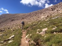
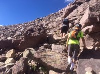
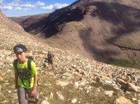
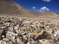
Here are some photos from Gunsight to Anderson:

This is right after you turn right at the top of Gunsight instead of dropping into Painter Basin. As you can see, the trail is well marked.
IMG_3846.JPG

This is the part where it's a bit of a scramble...nothing too bad at all.
IMG_3849.JPG

Then you get over the hump where you can almost see Anderson Pass and King's Peak. (Gunsight Pass in the background)
IMG_3853.JPG

Then the rocks begin. That's Anderson Pass to the right of center and you turn left and head up up up...all on rocks.
IMG_3862.JPG
 
@Parma pretty much answered your question to me too. The chute is something that can be fun to do just to say you did it, but like @Parma said, if I were descending back into Henry's from Kings or Anderson Pass, I'd probably go back down Gunsight. Just easier on the knees that way. It's pretty easy to hit a lose rock or scree going down the chute which can make for a painful, if not scary, experience. I had that happen about halfway down and quickly traversed over to the line of bigger boulders going down the chute where I found more stability with each step down. I really think you can get back onto the main trail in Henrys just as fast by going back down Gunsight because you'll have much more sure footing and don't have to be so careful with each step. There are ultra runners and hikers that will actually ascend Kings by going up that chute as well. I think that just makes everything harder on the lungs and at that altitude, would probably make it slower for me, despite the big decrease in distance, than it would be to stick to Gunsight.

With all that said, if you're looking to loop in a visit to Red Castle from Anderson Pass, you won't have to worry about which way to go back down. You'll just keep on the Highline going westward and descend into the Yellowstone basin. RE: Q3 - Ditching your packs at Anderson for the quick jaunt up to the summit is not only doable, but recommended.
 
Chiming in... The Highline stretches west from Anderson Pass into Yellowstone basin and once you get to mid-basin it is easy cross country travel north to the divide pass on the east side of Red Castle which is called Smiths Fork Pass. There is a trail to that pass coming from the north I have used. I didn't go down the south side of that pass but if the trail was missing it would still be easy route finding coming over from the south. The USGS topo shows the trail going up to Smiths Fork Pass so I am 90% sure it is still there and no big deal if it is not. This would make for a great loop and one I have in the planning list. Maybe with a car shuttle and starting somewhere way north of King's Peak (not the Yellowstone river - because of what my friends here have taught me).
 
To this point of my backpacking career I have strictly observed doing mountain passes & peaks in the mornings to avoid storms & lightning in the afternoons. I done almost 20 nights in the Uintas and have been stormed on during the day once. Should I stick to this rule or have I been overly cautious?
Ned, I use the same rule as a "rule of thumb" too. Have forever. Sometimes you can climb a peak in the afternoon and sometime you get whacked when you try. I just evaluate the forecast and the general trend in weather as far as afternoon bloomers and the overall wetness of the atmosphere are concerned. Then you play it by ear, more appropriately, I mean you keep your eyes and ears wide open. Generally it takes a long time to go up a peak but if you hear explosions or see flashes you can run right back down. And you can generally descend at a great increase in speed. Especially amped up with adrenaline...

Lastly you know the rule of thumb with thunder and lightning in the distance, right? You see a flash and start counting in seconds. Divide the total between the flash and the boom by six and that is the distance away, in miles, of the lightning flash and the approximate storm cell center. Helps you decide how fast to run. :help:

Caveat (or climber) Emptor!
 
Last edited:
With all that said, if you're looking to loop in a visit to Red Castle from Anderson Pass, you won't have to worry about which way to go back down. You'll just keep on the Highline going westward and descend into the Yellowstone basin. RE: Q3 - Ditching your packs at Anderson for the quick jaunt up to the summit is not only doable, but recommended.

Thank you all for your replies. I didn't ask this part very well - what I should have asked: is taking the ridge line from Gunsight to Anderson with packs doable? Being above tree line are there places to ditch our packs at Anderson?

Apologies for hijacking the thread.
 
Found this image. Was helpful for me to see that the Gunsight to Anderson isn't actually on the top ridge. image.jpg
 
The packs would be exposed up on Anderson, but I think p people will often build up little rock walls to stash them behind so they aren't so visible to the main line of traffic. Taking them on that shortcut from Gunsight to Anderson is totally doable, as seen in the pics from @Parma. I'd venture to say that your most exposed section would be on that initial stretch of the Highline heading west off Anderson, but that is still a well established trail, probably comparable to the trail around the summit and saddle of Timp.
 
Similar threads
Thread starter Title Forum Replies Date
Dave Kings Peak, Uintas (August 2-3, 2010) Backpacking 14
K Kings Peak Trip Trip Planning 6
Mike K Kings Peak Via Garfield Basin Backpacking 18
Ehouston24 Uintas Loop (Red Castle/Kings Peak) Trip Planning 14
DrNed Red Castle Kings Peak Henry's Fork Take Two Backpacking 8
JackBurns Kings Peak at 50 General Discussion 13
Skiwi Kings Peak in mid July? Trip Planning 5
Perry Injured Utah Hiker Rescued Near Kings Peak General Discussion 9
Kishenehn Kings Peak in 1930 ... General Discussion 2
Ben uintas, kings peak from swift creek th Backpacking 5
Nick Missing Hiker on Kings Peak General Discussion 3
WillisBodillus Kings Peak (7/31-8/2) Backpacking 7
shredhiker Kings Canyon July 2022 Kearsarge, Rae, & Sixty Lakes Backpacking 8
balzaccom Kings Canyon NP Day Hikes Hiking & Camping 3
norwegianxplorer Mt Whitney Virtual Hike via Horseshoe Meadows & Mt Langley, Sequoia Kings Canyon National Park Backpacking 1
Muddy Waters Stevens, Fold, Escalante River, Fools, Kings Mesa Trip Reports 3
norwegianxplorer Big SEKI loop, Sequoia Kings Canyon Backpacking 1
WasatchWill A Birthday Along the 'Kings Castle' Loop Backpacking 11
norwegianxplorer Bear Standoff and Bluff Charge in Kings Canyon yesterday June 30th Backpacking 16
peakbagger1971 Kings-Emmons ridge Trip Planning 1
BobFink Goschute Mountains, NV , Pisgah Peak, Hawk Watch Migration Site Everything Else 3
TheMountainRabbit Ortenburger Lake, Talus Lake, & Glacier Peak (Grand Teton NP) - October 2023 Backpacking 14
scatman Ensign Peak to Grandview Peak - October 9, 2023 Hiking & Camping 30
scatman Yellowstone's Thorofare, Headwaters of Thorofare Creek, Majo Pass, Younts Peak, Bob's Canyon, and Cub Creek - August 9, 2023 - Days 7 through 10 Backpacking 34
scatman Yellowstone's Thorofare, Headwaters of Thorofare Creek, Majo Pass, Younts Peak, Bob's Canyon, and Cub Creek - August 9, 2023 - Days 1 through 6 Backpacking 56
RockyMntCol Trip Planning Younts Peak / South Fork Yellowstone Trip Planning 12
T Cloud Peak backpack Trip Planning 0
RockyMntCol Cloud Peak Wilderness Loop Trip Planning 1
scatman Reid's Peak - Uintas - July 22, 2023 Hiking & Camping 6
W Paper map for Teton Wilderness (Younts Peak) Gear 4
scatman Grandeur Peak - Dragon Tail Route - June 10, 2023 Hiking & Camping 13
scatman Lookout Peak - May 27, 2023 Hiking & Camping 13
scatman Frary Peak - Antelope Island - February 20, 2023 Hiking & Camping 10
scatman Ensign Peak - November 24, 2022 Hiking & Camping 11
scatman Grandeur Peak - November 11, 2022 Hiking & Camping 15
Titans What’s your unfinished business? Hard canyon access, mtn peak, you name it! General Discussion 54
ram Eldorado Peak 2022 Backpacking 3
TheMountainRabbit Younts Peak (Teton/Washakie Wilderness) - July 2022 Backpacking 22
regehr Lookout Peak 6/25/22 Hiking & Camping 3
scatman Unnamed Peak 8194 - June 25, 2022 Hiking & Camping 17
scatman Mendon Peak - Wellsville Mountain Wilderness - June 4, 2022 Hiking & Camping 13
scatman Dale Peak - May 22, 2022 Hiking & Camping 21
westy Invite Glacier Peak, Washington Meet Up (Members Only) 2
TheMountainRabbit Invite Younts Peak, July 2022 Meet Up (Members Only) 11
LarryBoy SLC: Terrace Hills Drive to Big Mountain Peak Trip Planning 16
ram Glacier Peak July 2021 Backpacking 9
scatman Grandeur Peak - January 15, 2022 Hiking & Camping 6
scatman Frary Peak - Antelope Island - January 7, 2022 Hiking & Camping 21
Wanderlust073 Raleigh Peak Hiking & Camping 4
scatman Grandeur Peak Loop - December 4, 2021 Hiking & Camping 4

Similar threads

Back
Top