Navigation
Install the app
How to install the app on iOS
Follow along with the video below to see how to install our site as a web app on your home screen.
Note: This feature may not be available in some browsers.
More options
You are using an out of date browser. It may not display this or other websites correctly.
You should upgrade or use an alternative browser.
You should upgrade or use an alternative browser.
Island in the Sky: Cheatin and I Know It
- Thread starter SKLund
- Start date
chandlerwest
Member
- Joined
- Feb 7, 2015
- Messages
- 550
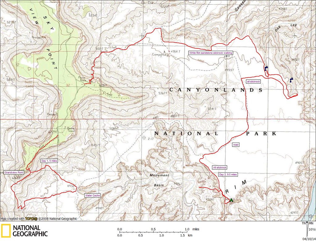
Take the Gooseberry Trail then walk the road. I can't help you with how to get into the basin. Looks like it is a pretty crisp edge. The trail head is just north of Grandview Pt.

Udink
Still right here.
- Joined
- Jan 17, 2012
- Messages
- 1,734
Steve Allen describes a sheep trail in Utah's Canyon Country Place Names that descends from the White Rim into Monument Basin starting near elevation 4900T on the USGS 7.5' topo. I can't locate the trail in the satellite imagery, but I'd wager it starts right about here: https://caltopo.com/map.html#ll=38.29912,-109.81139&z=19&b=sat
John Morrow
Member
- Joined
- May 22, 2015
- Messages
- 1,102
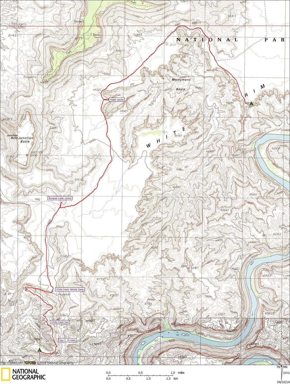
Entrance shown by "Day 2 9.5 Miles"
 April 5 and 6, 2014 by John Morrow, on Flickr
Traverse from below White Crack entrance on wide ledge around 4700' should go too.
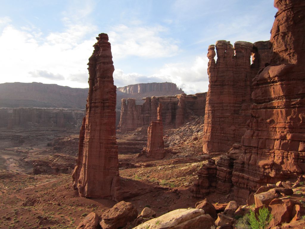
 April 7, 2014 by John Morrow, on Flickr
Part of this TR where pics and text detail the mapped entrance east of the Basin:
http://www.nwhikers.net/forums/viewtopic.php?t=8010081
April 5 and 6, 2014 by John Morrow, on FlickrTraverse from below White Crack entrance on wide ledge around 4700' should go too.
April 7, 2014 by John Morrow, on FlickrPart of this TR where pics and text detail the mapped entrance east of the Basin:
http://www.nwhikers.net/forums/viewtopic.php?t=8010081
John Morrow
Member
- Joined
- May 22, 2015
- Messages
- 1,102
Have you gone?Howdy,
I'm looking for a way into Monument Basin from the White Rim without getting a "Kelsey Headache".
Obliged I am.
norwegianxplorer
Norwegian Xplorer
- Joined
- Apr 1, 2018
- Messages
- 111
Howdy,
I'm looking for a way into Monument Basin from the White Rim without getting a "Kelsey Headache".
Obliged I am.
Here is a gps track of a route I followed, old post I see now, but anyway, did you go down there?

RyanP
Member
- Joined
- Mar 1, 2015
- Messages
- 700
@John Morrow and @norwegianxplorer---It looks like you both entered Monument Basin in the same general area (which is probably Allen's sheep trail route referenced by @Udink); how hard was that descent? Class 2? Class 3? It seems like I read somewhere that you can also enter the basin from the South (from the White Rim), but I can't find that info now... do any of you know about that route? I'm intrigued with the idea of entering the basin from the East (like both of you did), and then exiting via the South
John Morrow
Member
- Joined
- May 22, 2015
- Messages
- 1,102
That map looks very accurate. I remember one small drop off right at the top, like maybe a tiny dryfall? After that the little north traverse was sidehill and the descent was scree and draw. I didn't make any mental note of perhaps not wanting to take a full pack down. That was part of the reason for the route scout, to go back someday and get down below. Honestly, from vague memory I'd say 1 Class 2 more or two. Government trail required far more concentration!@John Morrow and @norwegianxplorer---It looks like you both entered Monument Basin in the same general area (which is probably Allen's sheep trail route referenced by @Udink); how hard was that descent? Class 2? Class 3? It seems like I read somewhere that you can also enter the basin from the South (from the White Rim), but I can't find that info now... do any of you know about that route? I'm intrigued with the idea of entering the basin from the East (like both of you did), and then exiting via the South
fossana
Member
- Joined
- Jan 11, 2018
- Messages
- 1,035
There are also a few climber approaches described here: https://www.mountainproject.com/area/120539387/monument-basin
RyanP
Member
- Joined
- Mar 1, 2015
- Messages
- 700
Thanks, that's what I was hoping to hear. Yeah, I have no interest in the Government Trail based on your trip report!That map looks very accurate. I remember one small drop off right at the top, like maybe a tiny dryfall? After that the little north traverse was sidehill and the descent was scree and draw. I didn't make any mental note of perhaps not wanting to take a full pack down. That was part of the reason for the route scout, to go back someday and get down below. Honestly, from vague memory I'd say 1 Class 2 more or two. Government trail required far more concentration!
RyanP
Member
- Joined
- Mar 1, 2015
- Messages
- 700
Thanks, that's good to see a 3rd class gully is listed on the S side.There are also a few climber approaches described here: https://www.mountainproject.com/area/120539387/monument-basin
John Morrow
Member
- Joined
- May 22, 2015
- Messages
- 1,102
Hmm, actually, when I look closer norwegianexplorer and I entered in slightly different locations. The track follows the same idea, enter through a weakness in the white, then traverse below it northward, to a slope descent. But I was definitely north
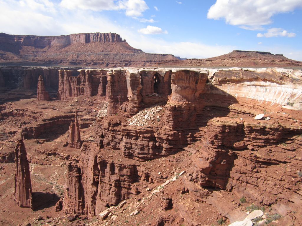 Evening among Monuments by John Morrow, on Flickr
 Canyonlands National Park, Island in the Sky District by John Morrow, on Flickr
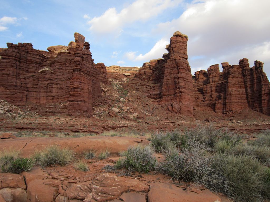 The way in by John Morrow, on Flickr
Evening among Monuments by John Morrow, on Flickr Canyonlands National Park, Island in the Sky District by John Morrow, on FlickrThe way in by John Morrow, on Flickrnorwegianxplorer
Norwegian Xplorer
- Joined
- Apr 1, 2018
- Messages
- 111
I had a very heavy pack so I was very careful, carrying 12L of water, didnt know about the spring down there until I was right on top of it, but I would say class 1 to 2, nothing to be concerned about if you do these sorts of things.@John Morrow and @norwegianxplorer---It looks like you both entered Monument Basin in the same general area (which is probably Allen's sheep trail route referenced by @Udink); how hard was that descent? Class 2? Class 3? It seems like I read somewhere that you can also enter the basin from the South (from the White Rim), but I can't find that info now... do any of you know about that route? I'm intrigued with the idea of entering the basin from the East (like both of you did), and then exiting via the South
John Morrow
Member
- Joined
- May 22, 2015
- Messages
- 1,102
I had a very heavy pack so I was very careful, carrying 12L of water, didnt know about the spring down there until I was right on top of it, but I would say class 1 to 2, nothing to be concerned about if you do these sorts of things.
I don't know about the spring...where are you referencing?
norwegianxplorer
Norwegian Xplorer
- Joined
- Apr 1, 2018
- Messages
- 111
There is a spring down there somewhere once you get closer to the colorado river. There is not really any info to find about it apart from in one of Kelseys books, it right where I have entered "camp night 1" on the mapI don't know about the spring...where are you referencing?
RyanP
Member
- Joined
- Mar 1, 2015
- Messages
- 700
Do you have a trip report for this? I'm intrigued to say the least. Did you go all the way down to the river from that campsite? Or did you meander down towards the canyons below White Crack? Or did you just explore Monument Basin and then head back out the way you came?There is a spring down there somewhere once you get closer to the colorado river. There is not really any info to find about it apart from in one of Kelseys books, it right where I have entered "camp night 1" on the map
norwegianxplorer
Norwegian Xplorer
- Joined
- Apr 1, 2018
- Messages
- 111
Ryan, I went from Gooseberry trailhead on Island in the sky, down to the White Rim, and entered Monument Basin from the South/East side. I walked the canyons below the White Rim towards the South/West for a couple of days and turned north to exit at white crack. I followed the road north towards the Murphys Hogback trail and climbed up to the Island again. Roadwalked back to the Gooseberry TH. I found water at camp 1 and also at camp 2. The first water source might be reliable, the second prob not. This was in May. I carried 12 L of water to start with, heaviest pack I ever carried. I have a recording of the route that I will make public for a few days so you can check it out. https://www.alltrails.com/explore/map/lower-basins-complete-f4334c1Do you have a trip report for this? I'm intrigued to say the least. Did you go all the way down to the river from that campsite? Or did you meander down towards the canyons below White Crack? Or did you just explore Monument Basin and then head back out the way you came?
Don't like ads? Become a BCP Supporting Member and kiss them all goodbye. Click here for more info.