- Joined
- Dec 2, 2019
- Messages
- 212
Update and warning December 2022: @IntrepidXJ Randy Langstraat reports in October 2022 that the narrow rock chute leading from Hole-in-the-Rock trailhead, down to the shore of Lake Powell, may now be impassable.
It was certainly a much trickier descent than I had envisaged, in April 2022, but I was able to complete it, with my backpack. From Randy's trip report, it appears that the route has degraded even further. Perhaps ropes/webbing would now be needed to make the descent/ascent.
See the map in the comments section below, for a possible alternative route to the lake from the trailhead.
Fiftymile Point to Davis Gulch & The Hole-in-the-Rock // ADVENTR.co
Canyons of the Escalante | Southern Utah Wanderings Wednesday – Friday, October 5-7, 2022 After spending the last day and a half along the western end of the Vermilion Cliffs we headed back o…
 adventr.co
===============================================================================================
Ok, where was I ? ... ah yes, my tent had just blown away ! ... not a great start to the day ...
After returning to the scene of the crime, I trudged around the immediate area, with a knot in my stomach, hoping against hope that I might spot the tent somewhere in the distance ... now I could finally see the advantage of a bright red or yellow colored tent ... it was just a pity mine was green. After wandering aimlessly for about 20 minutes, I caught a glimpse of what I thought was a plastic party balloon stuck in a bush a couple of hundred yards away. It couldn't be, could it ? Yes it was; it was my tent. It was spinning around madly in the breeze, but attached to a prickly bush by one of the guy-lines. Wow, I was incredibly fortunate to retrieve it. Thankfully, there would be no need to consider sleeping in damp alcoves for me, from now on
")
(Day 16 14.2 miles, Total 225.3)
=====
The views of the Waterpocket Fold had been wonderful over the past couple of days, but today it was time to scale the colorful sandstone slopes. Initially the walking over the slickrock was straightforward, and it was really just a case of heading upwards, using the easiest available route. Later however, the terrain got more complicated, with unexpected narrow, deep ravines preventing further progress. I was glad to have several GPS locations in this area to help me find the route (known as the Baker Route) up to the top of the Fold. Needless to say, the panoramic views from the top were quite magnificent, especially down into the canyon that I was now headed towards: Stevens Canyon.
The use-trail into Stevens Canyon was fairly sraightforward to follow, and after winding around some side drainages, I descended into the main canyon itself. There are some stunning red and white striped domes in the upper section of the descent. It's a curious drainage in many ways, with the route alternating between steep scree, a wide slickrock 'apron', and the canyon floor itself. It's often just guesswork, as to how to follow the drainage, but generally, in the upper portion of the canyon, the hike wasn't overly difficult.
(Day 17 13.6 miles, Total 238.9)
=====
Hmmm, did I say the hike wasn't too tough on the previous day ? Famous last words ! Less than 30 minutes into my second day here, the flat, wide sandstone apron I was walking along steepened dramatically, and it was necessary to head to a higher level, which meant the upper section of scree. In this particular area, the canyon curves dramatically and the scree slope becomes incredibly steep, with the trail narrowing to less than 18 inches wide. Between the right-hand edge of the path and the canyon floor is 100 vertical feet of fresh air ! Although this section is less than 200 yards long, it was literally the most terrifying path I have ever walked across. I was very, very grateful to reach more solid ground, and needed a few minutes for my shaking legs to recover. I am genuinely getting a cold sweat now, just remembering the experience.
One of the more infamous sections of Stevens Canyon is Poison Ivy Hill, where this plant grows in abundance on a steep muddy slope. I was certainly glad to have my hiking poles on this slippery descent. As pretty as the floor of this canyon is, one is always on the lookout for poison ivy, since there are large quantities in its lower section.
The exit of Stephens Canyon is very dramatic, with the Escalante River running past the canyon mouth. My next objective was a narrow side-canyon half a mile downstream. Due to the thick vegetation and sheer cliff walls, the only way to reach this drainage is to wade through the river, which can be tricky in parts due to some unexpectedly deep sections. Regular fierce battles with tamarisk are also required when one reaches dry-land. The small drainage downstream effectively forms a nice sneak-route into Coyote Gulch. It is steep and scrambly but easy enough to climb. At the top of the slope, I took the spur route that winds out on a narrow promontory to a point directly across from Stevens Arch, affording some wonderful views of the arch and the surrounding canyon system. After taking a narrow high trail above Coyote Gulch, I descended into the canyon and found a beautiful camping spot, surrounded by tall cottonwoods, with an amazing view of Stevens Arch in the distance.
(Day 18 15.5 miles, Total 254.4)
=====
I had visited Coyote Gulch on a couple of previous occasions as long day-hikes so, in some ways, I wasn't initially hugely excited to be returning here again. How wrong I was ! Looking back now on my entire trip, today's hike was possibly the overall scenic highlight. I had forgotten just how incredibly beautiful the canyon is, especially the lower section. I started early, well before the sun's rays reached the canyon floor, but the combination of the glowing red canyon walls, the deep green cottonwood trees, the gently flowing stream, and just the sheer peace and tranquility of the place had me in a vaguely hypnotic state as I proceeded through the gulch. It was undoubtedly one of the most stunning walks I have ever done. A glorious experience. The spell is slightly broken once one approaches Coyote Natural Bridge and Hamblin Arch, where the majority of backpackers and day-hikers congregate, but both these magnificent natural features are still stunning to see.
It was a long haul up through sandy Hurricane Wash to reach the Hole-in-the-Rock road, but at least I had a food resupply stashed near to the trailhead, so could enjoy a couple of bonus cereal bars after my meal this evening. I actually walked another 4 miles from the Hurricane Wash trailhead towards Dance Hall Rock, where I hoped to camp. However, no overnight camping is permitted close by, so I continued on another 1/4 mile, and found a nice spot in a sandy wash beside the road, with a great view of Dance Hall Rock. This particular natural amphitheater set in a huge alcove gets its name from the Mormon pioneers who spent some weeks here in 1880 and had evenings of song and dance on the large smooth sandstone floor, before they made their journey south towards the Hole-in-the-Rock.
I guess I had my own small moment of kinship with the pioneers that evening, because tomorrow I too was heading towards the Hole-in-the-Rock. This then was my final evening before I reached the section of my route that I had termed 'Miracle-Mile'. In a couple of days time, I would know if this difficult part of my trek could realistically be traversed. If not, I'd soon be returning back past Dance Hall Rock feeling rather forlorn. However, this wasn't the time for negativity; I was very excited about being so close.
(Day 19 20.6 miles, Total 275)
=====
My hike today would now intersect the route of the intrepid Mormon pioneers who first traversed the tortuous 200 mile route from Escalante, across the Colorado Plateau, over 140 years ago. The original intention of the group of 236 was to travel for 6 weeks across the red-rock country of Utah to reach Bluff. However the journey took almost 6 months due to the harsh winter and many unexpected obstacles that they had to overcome on the way. The most significant of these came only 2 weeks into their journey south, when they encountered a huge ridge of sandstone rock, towering above the Colorado River, with only a narrow slit a few feet wide for passage. It was therefore necessary to blast a wider gap in the rock, and improvise a 'road' on the other side, in order to allow the party and their wagons to fit through. Remarkably, after 6 grueling weeks of work, they were able to maneuver their 80 wagons and 1,000 head of cattle through the gap and down to the river. This gap is known as the famous 'Hole-In-The-Rock'. The ingenuity and determination of these pioneers throughout the journey was incredible, and they had several further serious natural obstructions to overcome before they reached their final destination.
As one travels along the modern Hole-in-the-Rock Road, and surrounding scrubland plain, there are a series of brown wooden posts in the ground, which indicate the route of these original 1880 pioneers. As I hiked along the dirt road, I passed several of these posts, which always provide a vivid reminder of the hardy 19th century settlers of this land.
Given my relatively enjoyable road-walks earlier in the trip, I was quite looking forward to hiking south along the Hole-in-the-Rock road, even though it was 18 miles until I reached the actual Hole-in-the-Rock itself. I had a few podcasts lined up for the day, and set off feeling good. However, this walk turned out to be extremely energy sapping, mainly due to the regular deep washes which run perpendicular to the road. Each wash requires a steep descent and then ascent, and my legs were getting heavier and heavier as the day wore on. I arrived at Hole-in-the-Rock late in the evening feeling exhausted, and before too long I was fast asleep in my sleeping bag. It had been a long day.
(Day 20 20.7 miles, Total 295.7)
After a great sleep, it was time to make the descent through the Hole-in-the-Rock gap down to the beach below. It is just incredible to think of the pioneers initially blasting a way through the rock, and then proceeding through the narrow gap. I hadn't quite expected the route down to be quite so steep and tricky; it turned out to be quite a challenge, and I needed to lower my pack down over ledges on a couple of occasions. Finally I made it down to the beach, and it was really quite beautiful, with large sections of lovely white sand adjoining the sparkling blue waters of Lake Powell.
I sat on the beach, fired up my stove to make a cup of tea, and looked out towards 'Miracle-Mile' straight in front of me.
.

.
.
This is what I had been working (and hiking) towards for all this time. My hope was that I could flag down a passing boat on the lake, which would ferry me the 1760 yards across the water, and leave me at the mouth of Cottonwood Canyon on the far side. The plan was then that I would hike through this canyon to reach Grey Mesa, Wilson Mesa, Death Valley, and Lake Canyon, before arriving at North Fork Castle Wash and Highway 276, which runs from Highway 95 out to Halls Crossing. It was an ambitious plan, but all would be for naught without a vessel to take me across this one mile wide stretch of water.
I really had no idea if there would be any boats at all on the lake, but hoped to maximize my chances by arriving here on the Easter weekend. My thinking was that, although it is well before peak boating season, this may be a weekend where families take to the water. I had discussed my idea with a friend, who is a long-time Lake Powell boat owner, and he was fairly skeptical of my chances; his final words being: "Well, I think you'll probably have to be quite patient".
The initial idea for this crossing came to me when I met a long-distance cyclist several years ago in Utah, who had been able to flag down a passing houseboat from the beach and get a ride across the lake. This had been in late May though, which could make a considerable difference to the amount of passing traffic. Although, how on earth he managed to descend the steep drop through the Hole-in-the-Rock gap with his bike and all his gear, I'll never know. In addition WasatchWill published a potential plan for the route a few years ago, which was a big help in developing my route.
I had considered bringing a packraft with me to make the crossing, but I just couldn't see how I would manage the extra weight, even if I had been able to pick it up at Hurricane Wash along with my food cache. It would also have been necessary to carry it onward, once I reached the far side of the lake. There are certainly people far fitter than I who could probably do this, but it just wasn't realistic for me. And the fact that I have never been in a packraft in my life, am a poor swimmer, and don't really like water, were also major considerations
It was 10.30am when I reached the beach on the Saturday of the Easter weekend. I was running one day later than schedule, since I had hoped to reach here on Good Friday, but I was delighted to be here in this lovely scenic spot, ready to flag down one of the many vessels that were sure to pass by on this holiday weekend !
So, there really isn't a lot of point detailing my entire weekend. It really just comprised of me sitting on a beach, enjoying the sunshine, munching Snickers bars, and staring out at a tiny 400 yard long stretch of Lake Powell. As relaxing as that was (and the break from 3 weeks of hiking was very welcome), there was not a single boat which passed the beach for the remainder of Saturday, and the whole of Sunday. I was beginning to feel rather stupid for attempting such a fool-hardy scheme.
The reality of the situation was sinking in. Given the current low water levels in the lake, it is only currently realistic for boaters to use the marina at Wahweap, near Page, Arizona, to launch their craft. Lake Powell (at high water mark) is approximately 140 miles long. I was currently staring out at a buoy in the lake with a painted number '66' on the side, indicating the distance from the Wahweap marina. Even on a sunny Easter weekend, 66 miles one-way is a long distance for any pleasure craft to travel on the lake.
Oh my goodness, what was I thinking ? How could I have ever thought that hitching a ride across Lake Powell in mid-April was a good idea ?
(Day 21 2.5 miles, Day 22 zero miles, Total 298.2)
=====
The other parts of the adventure can be found here:
"I Would Walk 500 Miles ..." - A Utah Adventure - April 2022 - Part 1
Despite the many frustrations of the Covid restrictions of 2020 and 2021, I had plenty of time to pore over maps, blogs, and guide-books and plan a big hike on the Colorado Plateau for Spring 2022. My previous long-distance hike in the US South-West in 2019 was a fantastic experience and I...
backcountrypost.com
"I Would Walk 500 Miles ..." - A Utah Adventure - April 2022 - Part 2
I was unsure whether to spend another day in Fable Valley to look for archaeological sites, but decided it was worth staying on a bit longer, if only to dry out my still wet clothes from the previous day. I hiked almost to the end of the canyon, which was a beautiful walk, but I didn't find any...
backcountrypost.com
"I Would Walk 500 Miles ..." - A Utah Adventure - April 2022 - Part 3
After the magnificent hike through Dark Canyon, and the desert traverse to Hite on Lake Powell, I hadn't really been looking forward to the next day of my trip, since it involved an early morning 7 mile road-walk along Highway 95. In order to reach the far side of the lake, and proceed on my...
backcountrypost.com
.
"I Would Walk 500 Miles ..." - A Utah Adventure - April 2022 - Part 5
I had now been camped at the beach below the Hole-in-the-Rock for almost 48 hours. It did appear that my plan to hike almost 300 miles from Needles to Lake Powell and catch a ride across the lake to Cottonwood Canyon and Grey Mesa had ended in failure. Not a single boat had passed by during the...
backcountrypost.com
"I Would Walk 500 Miles ..." - A Utah Adventure - April 2022 - Final Part
Although I had been carrying plenty of water, I hoped that I'd be able to refill my bottles at Lake Canyon. The dirt road from the highway out to Aladdins Lamp Pass used to skirt the edge of the canyon, but it has now completely collapsed and 4WD drivers now need to take a detour further south...
backcountrypost.com
=====
.
.

.
.

.
.

..
.
.
.
.
.
My tent spinning in the wind !

.
.
Grand Gulch

.
.
Southern Grand Gulch

.
.
Grand Gulch from Waterpocket Fold

.
.
Stevens Canyon from Waterpocket Fold, with Hole-in-the-Rock Road, and Fiftymile Mountain in the distance

.
.
The descent into Stevens Canyon

.
.
Stevens Canyon

.
.
Stevens Canyon

.
.
A side canyon of Stevens Canyon

.
.
Stevens Canyon and Poison Ivy Hill
 ..........
.
.
A large undercut in Stevens Canyon and Escalante River
 ..........
.
.
Following the promontory to Stevens Arch viewpoint

.
.
Stevens Arch

.
.
Escalante River

.
.
Coyote Gulch

.
.
Coyote Gulch

.
.
Coyote Gulch

.
.
Coyote Natural Bridge

.
.
Coyote Gulch and Hamblin Arch
 ..........
.
.
Coyote Gulch

.
.
The route of the 1880 Mormon pioneers

.
.
Dance Hall Rock

.
.
A long way to go !

.
.
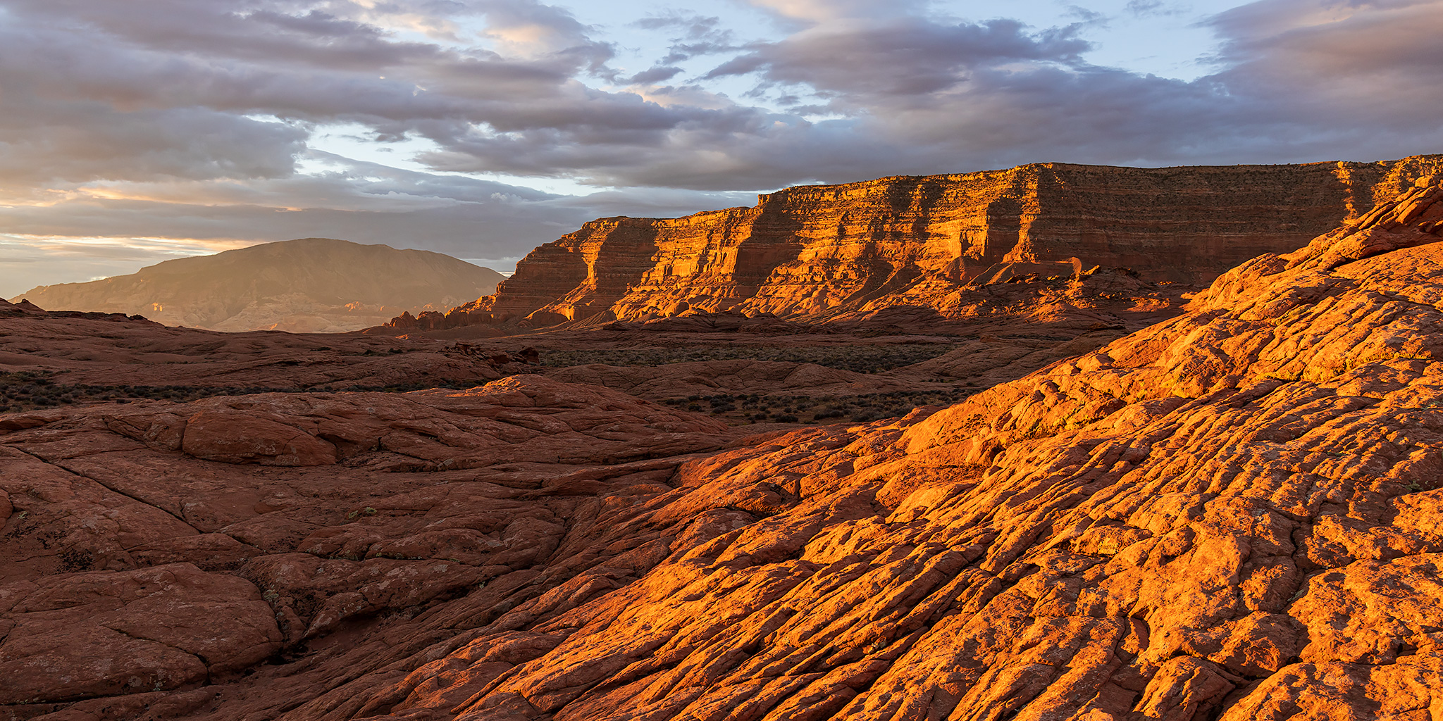
Looking north along Hole-in-the-Rock road with Fiftymile Mountain in the distance

.
.
Looking south along Hole-in-the-Rock road with Fiftymile Mountain in the distance

.
.
Hole-in-the-Rock road

.
.
The route of the 1880 Mormon pioneers with Navajo Mountain in the distance

.
.
The Hole-in-the-Rock

.
.
Looking down from above the Hole-in-the-Rock gap, across Lake Powell, towards Cottonwood Canyon with Aladdins Lamp Pass in the far distance

.
.
Looking down into the Hole-in-the-Rock gap

.
.
Stone steps carved by the 1880 pioneers

.
.
Looking back up to the Hole-in-the-Rock gap

.
.
The sandy beach below the Hole-in-the-Rock gap

.
.
Where are all the boats ?

.
.
"I would walk 500 miles,
And I would walk 500 more,
Just to be the man who walked a thousand
miles to fall down at your door" ... The Proclaimers
Last edited:


