How doable is the sneak route out of Death Hollow with kids and a dog?

climbhigh1119

Member
Joined
Jul 12, 2013
Messages
11
I have a Death Hollow trip planned with the family (2 kids age 11 and 14) and a doggo this fall. I am hoping to cut out a few miles of slogging along the Escalante by using the sneak route exit, but want to make sure that that exit will be doable by everyone.

The dog is on the small side so I'm fine carrying it in a pack up short, steeper sections if necessary. My kids both ascended the Jacob Hamblin Arch exit out of Coyote Gulch a couple years ago easily and do pretty well with exposure as long as it isn't too gnarly. If anybody has done both the Jacob Hamblin Coyote Gulch access and the Death Hollow sneak route, and can comment on how they compare, that would be great.

Thanks in advance!
 
I personally thought the escalante section was very beautiful. You can probably handle the sneak route if you did the Jacob Hamblin route (disclaimer: I've done neither. That's just my impression), but I wouldn't by any stretch refer to that section of the escalante as a slog. And I'm impatient with short subpar sections of hikes!
 
I personally thought the escalante section was very beautiful. You can probably handle the sneak route if you did the Jacob Hamblin route (disclaimer: I've done neither. That's just my impression), but I wouldn't by any stretch refer to that section of the escalante as a slog. And I'm impatient with short subpar sections of hikes!
Yeah, I've done the Escalante section before and agree with you - I found it quite enjoyable. I just know my kids' tolerance to how many miles they can do on a trip and still have a good time, and want to be careful to make sure that they keep having good experiences so that they keep wanting to do trips with me as they get older :).
 
What's the sneak route?
It is relatively short way to exit the Escalante basin shortly after coming out of Death Hollow, where you basically scramble up a steep sandstone ramp to the south where you have a car parked at an overlook, rather than hiking several miles to the east along the Escalante River to the Highway 12 bridge.
 
It is relatively short way to exit the Escalante basin shortly after coming out of Death Hollow, where you basically scramble up a steep sandstone ramp to the south where you have a car parked at an overlook, rather than hiking several miles to the east along the Escalante River to the Highway 12 bridge.
Copy, thanks. I wasn't sure if it was a quicker way up to the Bowington Route from closer to the Death Hollow mouth then where the original Bowington Route drops to the river further to the east (downstream). It is covered in C3. I think this is also covered in C3. .

The sneak route to JH Arch as a gauge opens lots of options. My guess is that JH Arch access would be more challenging. I could see many folks with overnight packs wanting a belay on the JH route.
Thanks,
John
 
Never tried it but met a guy who said he just dropped down in that way. He was wearing his pack on his chest instead of his back so I had a funny thought that he might be some kind of space alien who didn’t know how to wear it right. Girlfriend assured me I was just being silly. We met a lot of interesting people in there. Ever since then I’ve too wondered about that route, sounds interesting.
 
I have a Death Hollow trip planned with the family (2 kids age 11 and 14) and a doggo this fall. I am hoping to cut out a few miles of slogging along the Escalante by using the sneak route exit, but want to make sure that that exit will be doable by everyone.

The dog is on the small side so I'm fine carrying it in a pack up short, steeper sections if necessary. My kids both ascended the Jacob Hamblin Arch exit out of Coyote Gulch a couple years ago easily and do pretty well with exposure as long as it isn't too gnarly. If anybody has done both the Jacob Hamblin Coyote Gulch access and the Death Hollow sneak route, and can comment on how they compare, that would be great.

Thanks in advance!
Did you end up doing it (the sneaker route)? If so, how was it?
 
IMO, the route finding on headwall section of the sneak route out of Lower Death Hollow is less straightforward than the JH Arch sneak route. There's less sustained technical difficulty if you can navigate your way through the exposed ledges, but it's easy to get off-route onto steeper 4th class. I would not take a dog up it unless it can calmly be carried in a pack, and wouldn't take kids on it without a short rope.
 
Route finding on the sneak is complicated depending on the cairn status. Quite a bit of exposure in places. Done it several times with daypack. Retreated first attempt (1973) but had a heavy backpack and medium sized dog. You need to be comfortable with about a 25 ft upper 4th or lower 5th class unprotected crack scramble at the start of main head wall.
 
I had wanted to do the sneak route, but y'all are making me worried about it!

Just to be clear: are we talking about a very steep route that drops down a bit east of Micro Death Hollow, and then lands at the river about a quarter mile east of the mouth of Micro Death Hollow?

Also, are people aware that there's an old road dropping to the river about 1.5 miles east (crow-fly miles, not river miles) of the mouth of Micro Death Hollow? I have not walked it but it looks pretty chill, even with kids.
 
(I'm curious, because Road Trip Ryan has an exit just west of Micro Death Hollow, whereas the one I have mapped out -- but haven't walked -- is a to the east)
 
Nice steep slickrock but safer than the sneak route is go straight up at the end of the ledge section of the Bowington Road and then on to Head of Rocks. The Bowington Road is about 3 river miles down from Death Hollow - I believe that is what Regehr is referring to.
 
(I'm curious, because Road Trip Ryan has an exit just west of Micro Death Hollow, whereas the one I have mapped out -- but haven't walked -- is a to the east)
All the times I’ve done it were just west of Micro Death Hollow. They were done just over the ridge line of this headwall that is bisecting my head in this pic.20120917-BigFlat91.jpg
 
Last edited:
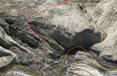
anyhow, here's the route I have marked that's a bit east of MDH. I don't know where I got this from but there's an obvious use trail towards the bottom, so people are definitely using this route

Screenshot from 2024-12-01 10-32-35.png
 
I've only done the one in the vicinity of the RTR exit. There's a use trail up to the base of the rock, but then you have to pick your way through the ledges/slabs. I've gone different ways for fun, but usually hit some exposed 4th class.
 
Your pic looks doable. Maybe sketchy just below the dogleg near the top. Take 20ft webbing.
 
Your pic looks doable. Maybe sketchy just below the dogleg near the top. Take 20ft webbing.
yeah my guess is this is easier than the one on the other side of MHD. however, I have been wrong before, when making predictions from Google Earth imagery
 
  • Like
Reactions: Bob
I get surprised loo9king at routes from GE....but not often. Looks like one I'd try.
 
Back
Top