Halls Creek and Muley Twist

Ross

Member
Joined
May 18, 2012
Messages
295
Halls Creek Narrows: Another place I’d got all planned to visit until storms stopped the plan a few years back.
But this time good weather was forecast and I had good company in the shape of Jack, Paul and Steve.

After much debate over whether to use the shortcut route, we opted for the longer one. The plus was that we got to find this spot near camp & we met nice people both nights at camp.

_MG_9654impsmaller.jpg

An early start - Paul was very proud of his filter coffee and we were grateful for it - and we headed for the far southern end of the Narrows to work our way back. I had hoped we’d have time to head up the slickrock to walk the rim and see some viewpoints looking down in. But we decided as it was going to be a long hike up to the tents later so we could run short on time as we were uncertain if there was a particularly good route to the rim that may take a while to complete. As it turned out we enjoyed the Narrows so much and went to slowly to take it in and get these photos that in hindsight the trade off for the rim would have been more rushed Narrows and less of these memories.

However, if anyone has shots from the rim please do post them as I’ve heard there are some great viewpoints and I’ve only seen a few great photos of the view from one spot on the rim posted from Nick's old trip on here. Would love to see more if anyone has spent more time up there.

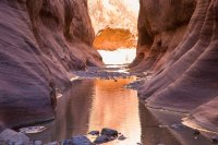
Colourful walls straight off

smaller001.jpg


smaller002.jpg
Steve loved rocks so took a close-up of this beauty

smaller003.jpg


smaller004.jpg
The photos say it all really.
but let’s say that after seeing the huge colourful walls of Paria years ago, Coyote Gulch and many nice canyons since, I knew I’d enjoy Halls, but wondered if afterwards I would regard it as not that special or different to warrant the effort and it’s place on my must-do list. Would it be more of a ticking-off exercise? More of the same-ish or not quite as good?
Well, the answer is I was still blown away from start to finish - hence well over 100 photos.

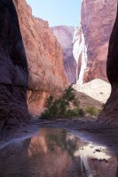
Water, immense walls, often vertical, deep undercuts. Luckily my two “models” - sometimes small specks you have to look carefully in the distance for to realise they are there - showed the scale.

smaller005.jpg


smaller006.jpg


smaller007.jpg


smaller008.jpg
A distant hiker showing the vertical height again


smaller010.jpg


smaller009.jpg


smaller011.jpg


smaller012.jpg


smaller013.jpg


smaller014.jpg


smaller015.jpg


_MG_9687impsmaller.jpg


_MG_9723impsmaller.jpg


_MG_9784impresized.jpg


_MG_9816imp3smaller.jpg


_MG_9838impsmaller.jpg

One of the best undercuts I've been to


_MG_9875impsmaller.jpg


smaller016.jpg


_MG_9888impsmaller.jpg


_MG_9737imp3_edited-1smaller.jpg

Not the prettiest photo, but hikers again show the scale

_MG_9832impsmaller.jpg

and again as Steve eats lunch

_MG_9899impsmaller.jpg


The view on the way back to the trailhead

smaller017.jpg


But what it did mean was that when I did Lower Muley Twist in full a few days later it DID appear like a nice hike but not so special. Perhaps it didn’t help that at one wash junction I took the wrong option which, with some late hunting around before finding the tiny hamburger rocks, I would complete 25 miles after 10 near non- stop hours and only beating darkness by 15 minutes.

But Muley Twist still had some colourful walls, and its own great alcoves near the end.

_MG_0138,9pano.jpg


_MG_0119imp.jpg


_MG_0122imp.jpg


_MG_0138,9pano.jpg


_MG_0157,8panoimpresized.jpg

Two of the only four people I passed

_MG_0162imp.jpg
Back at the trailhead, just beating dark was the most amazing pink twilight sky I've ever seen rising over the slickrock. I don't think this picture did it justice. It wasn't just pink clouds - the whole sky seemed to taken on a pink glow.

Shame the foreground for the shot was a restroom!


_MG_0169imp.jpg
 

Attachments

  • _MG_9846imp.jpg
    _MG_9846imp.jpg
    128.7 KB · Views: 12
  • _MG_9813imp2smaller.jpg
    _MG_9813imp2smaller.jpg
    111.6 KB · Views: 13
Upper or lower Muley Twist?


Sent from my iPhone using Tapatalk
 
Thanks for taking the time to make sure this got put up here. Those canyons were gorgeous.
 
Legitimately awesome TR and photos. I'm with @Jackson on this one. Perhaps we should team up and go @Jackson as my dad isn't feeling like he wants to hike this long of a hike and my wife and kids... yeah that's a no at this point in time as well.
And that's in reference to Halls Narrows.
 
This is definitely on my list for one day. Looks like such an amazing place. This is where Jamal ran into the flash flood as well right? *asking nobody in particular
 
This is definitely on my list for one day. Looks like such an amazing place. This is where Jamal ran into the flash flood as well right? *asking nobody in particular

Yes. It is. After his video I was glad the forecast was not a cloud in the sky. There’s a lot of escape spots but also a few you wouldn’t want to be in


Sent from my iPhone using Tapatalk
 
Great TR and photos! I have to do Hall's Creek now! How many days did it take to do it?
 
Great TR and photos! I have to do Hall's Creek now! How many days did it take to do it?

If you're happy doing the steep shortish cut route and you really rush through and are fit you could just about do it in a day. But I'd say leave at least two for either route. We got back to camp late on day 2 so decided to stay a second night, and then just hike out the last couple of miles and up the switchbacks first thing the 3rd morning. It's a bit of a toss-up - the easier you make the first day, the second day becomes much longer. But the further you go the first day before making camp, the more of the distance both ways you will be carrying a heavy overnight pack and less you will be with a light day pack.
 
Word of warning for those saying they want to do it. Make sure you get your overnight permit from the visitor centre. There was a ruthless ranger out there, ticketing everyone who didn't have one and it was something like $250. I'm sure she checks vehicles left at the trailhead. And there's a no hitching rule in the park which is bad news on hikes like Lower Muley Twist where the exit is different to the entry if you don't have a shuttle. One couple of Hayduke trailers had run into a problem or got lost and had little water and so wanted to hitch out the park to Boulder and she got them too. They were expected to walk about 50 miles!
 
Word of warning for those saying they want to do it. Make sure you get your overnight permit from the visitor centre. There was a ruthless ranger out there, ticketing everyone who didn't have one and it was something like $250. I'm sure she checks vehicles left at the trailhead. And there's a no hitching rule in the park which is bad news on hikes like Lower Muley Twist where the exit is different to the entry if you don't have a shuttle. One couple of Hayduke trailers had run into a problem or got lost and had little water and so wanted to hitch out the park to Boulder and she got them too. They were expected to walk about 50 miles!
WHAT???? Wow!
 
Word of warning for those saying they want to do it. Make sure you get your overnight permit from the visitor centre. There was a ruthless ranger out there, ticketing everyone who didn't have one and it was something like $250. I'm sure she checks vehicles left at the trailhead. And there's a no hitching rule in the park which is bad news on hikes like Lower Muley Twist where the exit is different to the entry if you don't have a shuttle. One couple of Hayduke trailers had run into a problem or got lost and had little water and so wanted to hitch out the park to Boulder and she got them too. They were expected to walk about 50 miles!

Wow! That seems harsh!
 
Nice job! I think I remember seeing your thread recently in doing my own research on here with this place where you were trying to get some company and/or help with transportation a few years back when you first wanted to do this. Or maybe that was someone else? Either way, awesome TR and I'm glad you finally got it all to work out for you. I'm curious, when about did you make it down there? I'm itching to get down there real bad myself, and have been trying to work things out with my wife to let me go down in early April...even if it means getting up at 4 am, making the 5 hour drive down (with a permit stop on the way), and making camp by afternoon and going partway up the narrows, before powering through the whole loop the next morning and and shooting back up to the trailhead that afternoon for the long ride back home that evening. Ideally though, I'd be able to spend 2 nights down there, with a night before and/or after at my in-laws in Torrey.

What you say about Lower Muley being less dramatic being so close on the heels of Halls Creek makes me think though. I had been planning to tackle the middle sections of the park first with each visit down there, and work my way south through UMT and LMT, saving the best for last at the southern tip down there, but I don't think I'm going to be able to resist holding off that long. Hopefully with time, exploring "less dramatic" sections of the park like LMT thereafter will still be very charming and beautiful in its own right.

EDIT: I forgot to also ask in connection with when you did it, how many people did you encounter while doing the narrows hike? Sounds like for most people that do it, they're usually alone the whole way or only bumping into another party or two at most. I wonder if it hasn't gotten more popular in recent years.
 
Last edited:
Nice job! I think I remember seeing your thread recently in doing my own research on here with this place where you were trying to get some company and/or help with transportation a few years back when you first wanted to do this. Or maybe that was someone else? Either way, awesome TR and I'm glad you finally got it all to work out for you. I'm curious, when about did you make it down there? I'm itching to get down there real bad myself, and have been trying to work things out with my wife to let me go down in early April...even if it means getting up at 4 am, making the 5 hour drive down (with a permit stop on the way), and making camp by afternoon and going partway up the narrows, before powering through the whole loop the next morning and and shooting back up to the trailhead that afternoon for the long ride back home that evening. Ideally though, I'd be able to spend 2 nights down there, with a night before and/or after at my in-laws in Torrey.

What you say about Lower Muley being less dramatic being so close on the heels of Halls Creek makes me think though. I had been planning to tackle the middle sections of the park first with each visit down there, and work my way south through UMT and LMT, saving the best for last at the southern tip down there, but I don't think I'm going to be able to resist holding off that long. Hopefully with time, exploring "less dramatic" sections of the park like LMT thereafter will still be very charming and beautiful in its own right.

EDIT: I forgot to also ask in connection with when you did it, how many people did you encounter while doing the narrows hike? Sounds like for most people that do it, they're usually alone the whole way or only bumping into another party or two at most. I wonder if it hasn't gotten more popular in recent years.

Yeah, that's Ross. I picked him up a few years ago to do it but there were too many storms. He was able to do a lot of other things that weren't prone to flooding. This year was the first week of October. I waited at the trailhead and there were always several cars. Not sure how crowded below.

I camped at the trailhead one year in July. I saw nobody else.
 
Nice job! I think I remember seeing your thread recently in doing my own research on here with this place where you were trying to get some company and/or help with transportation a few years back when you first wanted to do this. Or maybe that was someone else? Either way, awesome TR and I'm glad you finally got it all to work out for you. I'm curious, when about did you make it down there? I'm itching to get down there real bad myself, and have been trying to work things out with my wife to let me go down in early April...even if it means getting up at 4 am, making the 5 hour drive down (with a permit stop on the way), and making camp by afternoon and going partway up the narrows, before powering through the whole loop the next morning and and shooting back up to the trailhead that afternoon for the long ride back home that evening. Ideally though, I'd be able to spend 2 nights down there, with a night before and/or after at my in-laws in Torrey.

What you say about Lower Muley being less dramatic being so close on the heels of Halls Creek makes me think though. I had been planning to tackle the middle sections of the park first with each visit down there, and work my way south through UMT and LMT, saving the best for last at the southern tip down there, but I don't think I'm going to be able to resist holding off that long. Hopefully with time, exploring "less dramatic" sections of the park like LMT thereafter will still be very charming and beautiful in its own right.

EDIT: I forgot to also ask in connection with when you did it, how many people did you encounter while doing the narrows hike? Sounds like for most people that do it, they're usually alone the whole way or only bumping into another party or two at most. I wonder if it hasn't gotten more popular in recent years.

Yes. That was me a few years ago. It’s how I got to know @Glasterpiece as he offered to do the 4WD bit with me to save some extra miles hiking. I did it October. Spring and fall must be best to avoid the heat and lessen the chances of storms. We only saw a handful of people. I’m sure lmt and umt aare great and worthwhile. I’m just fussy as I’ve seen quite a bit of nice stuff and because I don’t live in the US I’m very choosy what to do as I can’t visit for a weekend. But the whole area is beautiful and enjoyable.


Sent from my iPhone using Tapatalk

What's on tap for this year?
 
Similar threads
Thread starter Title Forum Replies Date
Cody Halls Creek Loop via Lower Muley and Red Slide Backpacking 16
RyanP Coyote Gulch to Halls Creek via Steven's Canyon and the Baker Route (car/key swap) Meet Up (Members Only) 8
WasatchWill Halls Creek: Version 2.0 Backpacking 9
RyanP Coyote Gulch to Halls Creek via Stevens Canyon Trip Planning 28
Mikjik86 Backpacking Halls Creek Narrows. Backpacking 4
Mikjik86 Halls Creek Narrows Short Video Backpacking 0
Mikjik86 Halls Creek Loop. 2 Days, or 3? General Discussion 6
WasatchWill Halls Creek...It was time. Backpacking 14
Ross Invite Cathedral Valley,Halls Creek.Happy canyon,Bisti,Caineville Mesa + more Meet Up (Members Only) 4
sierrasummits Halls Creek, Moody canyon, Stevens canyon loop ? Trip Planning 5
Jammer Flash Floods in May? (Halls Creek Narrows Video) Backpacking 20
Ross Invite Halls Creek Narrows.....(& perhaps Needles/Behind The Rocks) Meet Up (Members Only) 12
Clint_N Halls Creek Narrows - May 2013 Backpacking 13
Nick Halls Creek Bay On The Water 22
Nick Halls Creek Narrows Backpacking 37
lostlandscapes Halls Creek Narrows, 4/6/13 Backpacking 23
pixie1339 Invite Halls Creek Narrows May 10th - 12th Meet Up (Members Only) 42
NateGeesaman Halls Creek Narrows of Capitol Reef July 2012 Backpacking 20
WasatchWill WRHR: Day 4 - Halls Lake to Camp Lake Backpacking 17
WasatchWill WRHR: Day 3 - 'Desolation Valley' to Halls Lake Backpacking 15
W 9 Days Solo Escalante Loop in October (water advice) - Stevens Canyon, Baker Route over Waterpocket fold, Halls Narrows to Moody Canyons Trip Planning 11
piper01 Escalante, Part 4: Dance Halls and Dinosaurs Hiking & Camping 3
rinats Canyonlands/Needles: Salt Creek to Chesler Park Trip Planning 6
shredhiker Slough Creek mid June? Trip Planning 11
Spud Salt Creek Canyon question Trip Planning 11
BobFink Mirror Plateau via Pelican Valley and Pelican Creek, July / August 2023 Backpacking 12
Janice Such a GRAND Canyon - Deer Creek / Tapeats / Thunder River Backpacking 21
Jackson Little Rock Creek Backpacking 5
scatman Yellowstone's Thorofare, Headwaters of Thorofare Creek, Majo Pass, Younts Peak, Bob's Canyon, and Cub Creek - August 9, 2023 - Days 7 through 10 Backpacking 34
scatman Yellowstone's Thorofare, Headwaters of Thorofare Creek, Majo Pass, Younts Peak, Bob's Canyon, and Cub Creek - August 9, 2023 - Days 1 through 6 Backpacking 56
J South Crandall Creek and the Hoodoos Wyoming and Yellowstone? Trip Planning 3
CodyL Maple Creek or Duck Creek Drainages-YNP Trip Planning 0
J Pacific Creek or North Buffalo Fork? Teton Wilderness, Thorofare ,etc. Trip Planning 10
I Rescue Creek - Yellowstone National Park - June 3, 2023 Backpacking 15
Dreamer Slough Creek - YNP - 6/5-7/23 Backpacking 3
shredhiker Blacktail Creek June 2023 Backpacking 4
Dreamer Rescue Creek -YNP - 6/3-5/23 Backpacking 3
shredhiker Slough Creek May 2023 Backpacking 11
scatman Rescue Creek - Yellowstone National Park - June 3, 2023 Backpacking 56
Gretchen Millward Trachyte Creek via Woodruff Canyon, April 2023 Backpacking 9
I Slough Creek - Yellowstone June 5 & 6 Meet Up (Members Only) 19
scatman City Creek Loop - April 23, 2023 Hiking & Camping 8
F Thorofare/South Boundary/Wolverine Creek Trip Planning 2
scatman Rescue Creek - Yellowstone National Park Meet Up (Members Only) 19
Janice When might road to Salt Creek TH be ok? Trip Planning 23
BobFink Yellowstone South Entrance to Fox Creek via Basin Creek Cutoff - Labor Day 2022 Trip Reports 4
Janice Professor Creek / Mary Jane Canyon - mid April? Trip Planning 0
scatman North Ridge of City Creek Canyon - February 4, 2023 Hiking & Camping 17
MikeP Exploring/Calf Creek Trip Planning 28
scatman South Ridge of City Creek Canyon - January 28, 2023 Hiking & Camping 4

Similar threads

Back
Top