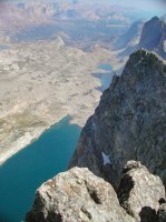
Guess the spot

Sorry, I shouldn't have posted this while working... dang customers came for a visit.


Yes, it is in Cathedral Valley... they do not have a name on the map, but I have heard them called the "Lesser Temples". The Temple of the Sun and Moon are right behind me.
I knew it was easy, even when I cropped out the ridge line behind them.
You cropped out a detail? Can we see the original picture please?
 
You cropped out a detail? Can we see the original picture please?

Sure. It would have been too easy with this distinctive geology...
Kv9L0QXcN99YvGx07-a4ccWbYz1pYY3kb031qfe0l3XBUHouLJUSEPxNZ2fCQmk0SDHrv4dA1KS-CSscjRjSESkkkAiaP7lSVzcyea_5a5CPJ42GtPgGY8ou7shOgoG1pDVnmwhlz5t9O5Telu88WHGaLEtlyxi9UA9bdGf85LO6hZpS5Gm37_3fi9ySlricV_shglZjlRKszxNzXV6sh1vs3wI5ysXvlbHYteRHcsUe2wa0Gk8rd5cr24YJ_Vdy8TVzTwG0mBR41S4l2axjm_B95WvONK6XPn6M0OEvfBtAVcJ0NfFjtbZtYg1X3qk0mBXA10myTxVoGYG2gGUPI9WPQJF4Cg4hrX5WbXDHyJJjyezMFcmVNOPdx2eP49TjN5zcl7nWAsBYCTuu8hOxLAjla8R2Q1hTU7PBGSN6xqTAcFVZi8_EqbrNvayKBKdNzIrX6OlwxR-Fkm8L6ddbZBmz7Q77KPMqOtiBhBioBy931KFYfrQZhrrvrxnQt_ugNxlFvoDoFnYw4t4znAJn4V2ighX1nFYgw3Gyvlhg8MHQHvpwKsa2PCBu0I-4MGHqkCxToHztS0jfRiiY-tmFT_HDCIvILpzdNv-EhcQNBf_gJD8TJiAKJA=w1006-h567-no


or looking back toward them with the Sun and Moon being the smaller ones off in the distance.
t7YSpa5NN0fp8SoziOj_1Y3HYpyn4Z2YXVzO2bZ5vFhTz4ONdKzaxzmY2DdVb3alY7gEvj9bD8EyWOsEGCjJsTB4xSt5vxcVkw1qqxJNoBq36rHV7DVA2rT6klGz7E5FHlI0axNGohEMUoB5FUcRJgkE8Bj4wD_Wo2GiXFRKuZ9FW6lOGP4cSBzFbSwjpxRGP_i7LgEvhJBQGitHJ_Ow3AwwlNmd_plYyDFxzf8cRNJ6J1FPfFhQI95qMUg9DvgJKaQ-SG_sAHZZaJzo_4rqaSdPHA3XsTaDcowob4RlSaxTmn63_oumE4AVU0fK4d8dHUGH0fY_tIj6wD_771xxsmMe2LYka-Kx0kwwxPWA1Y1QAniTlZ5SVl1sdIJhwP9bH1P-Oz2MawHl7MZtOpkkJXcmzPIikX8CaLft7iNHqCMjsY1ZFCZ0eS4ZQHiV4SsHA07BSOrVfjRQfM2nirzg8XUmbD5CjORyOuVkv3cr9pUxQhGEPEtMfEJrRlyQshKnTn_6UjmlQHNFDmuHxTgB078qeUViFTe7HJUbnZYgT49x-x9LWXZ0fUfprwB4n1RNqpocm3h49W-COf7a8K9k5_fNQMXzqt7eXZ9d-qB3x9y2AnNiRr-fFQ=w1366-h427-no
 
Name the valley or, for extra credit, the peak I am standing on.
View attachment 50923

If it is where I think it is... then those are nice lakes! It looks so much more rocky and not full of life from up there.

I hate to tease on this, but I have to run. If no one has guessed when I am able to get back later tonight, then I will venture a guess.
 
Raid Peak?
Looking down at Desolation Valley.

Reading your reports, I would guess it was not just a walkup?
From this side... seems more of a climb ;)
21ypbLQ1gsbPfn34feCW8TnbRFw-pssHRTrrYVsdM8C0n3fDtRmSFO_FxKBuQKJDZhLd5v5ng2G5-RxGgTF0Wl9CYAaXWxxwRDx2pJ4XOkQLrAE1kzO_kXTsVpokUXgKGOH7DZcp192MiAJEbCrHaZpHRcvtjaW1QcA89veXIVkGt_vgTYKJ7FTI0ApDRRB5Pqe6GQM3DSlgmWOZyXnp6rHA8Kpy1WZC_EUguwWMNHf1hmN6pqFIMbF2XrRgtGvBWGY3GFjwWsyJHUuk1_aual-1jFYTXD5gTkIwNynRQ8gPmNpRmZ2k6vyODjRtQI9J8VOeAwY08-3AugIOujX-1r6PVD5KfirmNDcjeI49n_va6OM-jaYG3tPQ9bvyUQKJ-mFTHB2hhn6DnuNxYB1BDxwF-Roy72RjZ7LNZPSSMVHSEFiU0EvIvl-vn6gTLR_C0WgqcFk3ZZR4M09qJtESvoeK6gL5RILB9u0wwgRboRvtVydS6njaq8ItwyUiRJozmY9X2vZb6xdsQExpveOI4diozmG40NOK7rDDZlwzCtH4B9Z-HsiZwKQEUoSymo0oV4YAq48N7bqYeEfdn0kpOwuUcE3pC0WhX3s2iO_1jLoYGN1irmLkpg=w994-h662-no
That is the place, although it is called the East Fork River Valley as far as I know. Where have you seen it named "Desolation"? You're up.

It WAS a simple boulder-hop, walk-up, from that right or north shoulder between Raid and Bonneville. You get extra credit!
 
It's a great view, it makes Midsummer Dome in the center of the picture look like an anthill.

For Desolation Valley, I haven't seen it on any maps, but when I had been researching areas to go in the Winds, I saw reports with it named that or even East Park Lakes. Not sure why Desolation, and also not sure the real reason the peaks along that ridge have such awesome names: Raid and Ambush... Geitke...
Some day I will go back and take the pass and throw in the boulder hop then.
 
I tried last night to find pictures of my time up in the great white north, but back then we just didn't take many pictures, and looks like I did not scan any of them.

So instead I came across this one... how about the drainage/valley or trail where this is located:
vTBKCP0nkw96VREObKRrRSNXrJ59eyYa5XBHYPyikLn3kKe-3BUehBj5i3wejLgGr5y51Wcjvyg=w1128-h974-no


Pretty sure it is recent and not ancient, but never found anything about it.
 
It's a great view, it makes Midsummer Dome in the center of the picture look like an anthill.

For Desolation Valley, I haven't seen it on any maps, but when I had been researching areas to go in the Winds, I saw reports with it named that or even East Park Lakes. Not sure why Desolation, and also not sure the real reason the peaks along that ridge have such awesome names: Raid and Ambush... Geitke...
Some day I will go back and take the pass and throw in the boulder hop then.
Thanks.
Well everyone I know including the guide book author call it East Fork. The legend about the peak names are that there was a range war going on between the sheep ranchers and cow ranchers over the area and their war generated the names. Geike's name is also explained - I just can't remember off the top of my head at the moment. Let me know when you are heading to the summit and I will give you some more beta if you want.

I will have to do some reading on the history there.
It may take another summer or so before I get back and ask for beta on Raid. I think this summer my hiking buddy is hung up on going somewhere on the east side of the Winds that a friend of his was talking up. Perhaps I can do a second trip.
 
I tried last night to find pictures of my time up in the great white north, but back then we just didn't take many pictures, and looks like I did not scan any of them.

So instead I came across this one... how about the drainage/valley or trail where this is located:
vTBKCP0nkw96VREObKRrRSNXrJ59eyYa5XBHYPyikLn3kKe-3BUehBj5i3wejLgGr5y51Wcjvyg=w1128-h974-no


Pretty sure it is recent and not ancient, but never found anything about it.
Any hints?
 
Back
Top