Navigation
Install the app
How to install the app on iOS
Follow along with the video below to see how to install our site as a web app on your home screen.
Note: This feature may not be available in some browsers.
More options
Style variation
You are using an out of date browser. It may not display this or other websites correctly.
You should upgrade or use an alternative browser.
You should upgrade or use an alternative browser.
Guess the spot: Utah Edition
- Thread starter Ben
- Start date
Pukwudgie
Member
- Joined
- Jun 18, 2021
- Messages
- 209
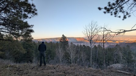
I haven't been here, but could it be Elk Ridge maybe above Hammond Cyn?Haha, mine was a shot in the dark, but I took this photo a month ago with Guess the Spot in mind! (don't worry, he's not peeing in the photo)
Pukwudgie
Member
- Joined
- Jun 18, 2021
- Messages
- 209
Nice, Hammond is high on the list, did you get down there? I'll see what I can find for a pic.Bingo! Right on. This spring was my first time up there, and it was gorgeous! You're up!

John Morrow
Member
- Joined
- May 22, 2015
- Messages
- 1,147
4405T
Pukwudgie
Member
- Joined
- Jun 18, 2021
- Messages
- 209
That's a Bingo. Escalante looking toward Navajo Mtn. from the rim straight east of the "crack in the wall" e/e to Coyote Gulch. Good job John you're up.4405T
John Morrow
Member
- Joined
- May 22, 2015
- Messages
- 1,147
Process of elimination, I suppose. Looked Escalante based on water flow, Navajo Mtn and rock layers. Then noticed almost no wingate really visible so must be down canyon when it became clear that the vegetation was within the high water mark of Powell. Then a quick topo look for a straight stretch of canyon downstream of CoyoteThat's a Bingo. Escalante looking toward Navajo Mtn. from the rim straight east of the "crack in the wall" e/e to Coyote Gulch. Good job John you're up.
Fun. I'll have to come up with a pic now.
John Morrow
Member
- Joined
- May 22, 2015
- Messages
- 1,147
That's a Bingo. Escalante looking toward Navajo Mtn. from the rim straight east of the "crack in the wall" e/e to Coyote Gulch. Good job John you're up.

That crazy thumblike spire has no name I am aware of. The greater mesa that it rises from is a known feature and named on USGS maps, as is the canyon descending off right. Give me an approximate location of the photopoint or the thumb, or name the mesa or the canyon.
Last edited:
Udink
Still right here.
- Joined
- Jan 17, 2012
- Messages
- 1,748
The Google Earth view doesn't quite do that spire justice:

I have a trip planned there for someday, a one- or two-nighter, hauling a bunch of water 'cause it's pretty dry on the mesa. I heard from a good ol' Emery County boy about an old stock trail between the mesa and Saddle Horse Canyon, and I noticed a corral on the mesa at the top of the trail in Google Earth. Then I later heard or read somewhere that the route is in some Kelsey book and he calls a nearby peak "Cyclone Peak" but I'm not sure which landform it refers to--maybe it's that spire? Anyway, it's peak 6,985' on the southern end of the Sid's Mountain plateau.
I have a trip planned there for someday, a one- or two-nighter, hauling a bunch of water 'cause it's pretty dry on the mesa. I heard from a good ol' Emery County boy about an old stock trail between the mesa and Saddle Horse Canyon, and I noticed a corral on the mesa at the top of the trail in Google Earth. Then I later heard or read somewhere that the route is in some Kelsey book and he calls a nearby peak "Cyclone Peak" but I'm not sure which landform it refers to--maybe it's that spire? Anyway, it's peak 6,985' on the southern end of the Sid's Mountain plateau.
John Morrow
Member
- Joined
- May 22, 2015
- Messages
- 1,147
That's hilarious.
I knew you would know right away @Udink but wondered if you might stay quiet. It was your trail from the east that got us there afterall. Much appreciated.
Other than Allen's route into Saddle Horse entry, not much looks appealing on GE. Perhaps the stock trail was somewhere on that slope. Glad you are going in to find out.
John
Udink
Still right here.
- Joined
- Jan 17, 2012
- Messages
- 1,748
For this one, the range/peaks on the horizon are probably easy to figure out, but it would be cool if anyone can identify the towns below or maybe even the spot where I was standing when I took this (I was near a named feature/high point on the USGS topo).

John Morrow
Member
- Joined
- May 22, 2015
- Messages
- 1,147
Yikes, I'm clueless!
Pukwudgie
Member
- Joined
- Jun 18, 2021
- Messages
- 209
Nice, does that put you at the summit of Sid Mountain? Or is this a duel summit situation as you're at the same elevation as the spire?View attachment 150473
That crazy thumblike spire has no name I am aware of. The greater mesa that it rises from is a known feature and named on USGS maps, as is the canyon descending off right. Give me an approximate location of the photopoint or the thumb, or name the mesa or the canyon.
John Morrow
Member
- Joined
- May 22, 2015
- Messages
- 1,147
Yes, pretty darn close. I can't quite remember if the photo was from the actual highpoint but somewhere close on the south end of the higher mesa. Then we headed north to Swazy and searched for rock art around what I think is locally known as Long Hollow.Nice, does that put you at the summit of Sid Mountain? Or is this a duel summit situation as you're at the same elevation as the spire?
Udink
Still right here.
- Joined
- Jan 17, 2012
- Messages
- 1,748
Here's a clue: Mount Nebo is on the horizon on the right side.For this one, the range/peaks on the horizon are probably easy to figure out, but it would be cool if anyone can identify the towns below or maybe even the spot where I was standing when I took this (I was near a named feature/high point on the USGS topo).
View attachment 150475
Udink
Still right here.
- Joined
- Jan 17, 2012
- Messages
- 1,748
Goshen is on the far side of Nebo in the photo.Looking across Goshen ?