Jakeuhdavis
Member
- Joined
- Aug 6, 2024
- Messages
- 34
Somewhere along the pleasant creek trail in capitol reef?Not near factory butte, and not butler wash (different monocline).
Follow along with the video below to see how to install our site as a web app on your home screen.
Note: This feature may not be available in some browsers.
Somewhere along the pleasant creek trail in capitol reef?Not near factory butte, and not butler wash (different monocline).
Halls creek? If not I’ll let someone else take a guessCloser! Think more south.
got any more info about this? I've been in this part of Hall's Creek and never knew there was an exit there. and the internet isn't helping.Yup! That's Halls Creek right at the southern border of CRNP. The sign used to mark the " Wolverton Exit".

The Colorado River is not far from where this picture was taken
 Here’s looking up canyon
Dang, looks like FunThat’s it! You’re up
You're up again sirGrand gulch?
Is that the main route where you drive up to the edge?hmm, there's just a bit of trail visible in the GE imagery. the green line is the park boundary. I'd be interested to hear how sketchy this is, I love this area and would like a better alternative to the canyoneer's sneak route a half mile to the south.
View attachment 147418
Both this route (from the post above) and the canyoneers sneak route are only reachable via a cross-country hike from the Notom-Bullfrog Road. The main route with the established trail is several miles to the north of this.Is that the main route where you drive up to the edge?
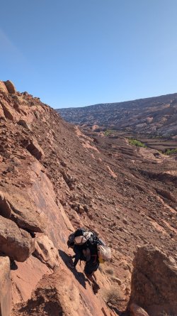
This route is great. It is less technical than the "Kingdom Route" half a mile to the south. There was one ~15-foot cliff that was 3rd/4th class with really good Moki Steps (See photo). I went from the bottom up, and it was easy to find. If I remember correctly, we stayed on the red line (the one in the screenshot) at the lower elevation, then kept going straight up until we got above the third cliff band. Then we traversed ~150 feet to the saddle/sign/park boundary. Hopefully that makes sense. I believe the moki steps were on the highest cliff. But regardless, the route should be very easy to find from the top (Due to a good trail leading from the sign to the south, then on to the crux) and the bottom (Easy to see the whole route if you stay south of the saddle).hmm, there's just a bit of trail visible in the GE imagery. the green line is the park boundary. I'd be interested to hear how sketchy this is, I love this area and would like a better alternative to the canyoneer's sneak route a half mile to the south.
View attachment 147418
Escalante vibes...Maybe somewhere in Harris Wash?

.jpg")