Guess the spot: Utah Edition

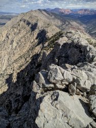
I am pretty sure you are looking south across Parunaweap/The Barracks as the white cliffs with a bit of red are pretty distinctive, but the peak's name. No idea. Means you could be standing on any number of peaks or ridges on the east side.
 
Ah, I knew that wasn't the exact view from by Checkerboard, but that makes sense.

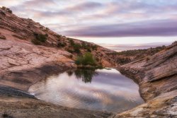
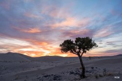
Alright, let's try this one. A morning shot. If there needs to be a hint, I will give a different angle.
Memorial Day Romp 5-20190840-recipe.jpg
 
Here is a hint, before I show a different angle.
This is not an ephemeral flow and thus not a tank. I almost fell on the wet sandstone taking this.
 
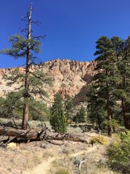
Here is a hint, before I show a different angle.
This is not an ephemeral flow and thus not a tank. I almost fell on the wet sandstone taking this.
Here is a hint, before I show a different angle.
This is not an ephemeral flow and thus not a tank. I almost fell on the wet sandstone taking this.
Its the pool above upper Calf Creek falls
 
Never been there, but that has to be the Kolob District of Zion in the background, so red and boxy, no? With a big foreground valley pointing that way. I'll go with Big Point, but I don't think I am right. Nothing lines quite right with the topo. Pine Valley Mountains in general I have some confidence in.
 
I think @John Morrow you're a little too far west.

Along Black Ridge? if you look to your left you see I-15.
It looks more gray on top than it does from below.
 
I think @John Morrow you're a little too far west.

Along Black Ridge? if you look to your left you see I-15.
It looks more gray on top than it does from below.
Oh, that makes much more sense. The long valley was a confusing feature for me, so it's LaVerkin Cr, huh? The side drainage draining toward the photographer and into LaVerkin is distinguishable. Anderson BM, then? Wherever it is, I wanna go. Unless it's a local's thing, I can't see it being popular. Love the limestone
 
Oh, that makes much more sense. The long valley was a confusing feature for me, so it's LaVerkin Cr, huh? The side drainage draining toward the photographer and into LaVerkin is distinguishable. Anderson BM, then? Wherever it is, I wanna go. Unless it's a local's thing, I can't see it being popular. Love the limestone

It's a great walk. Yes, Anderson BM but you can follow the ridge for as long as you like. It is certainly not popular, which is way its so nice.
 
Similar threads
Thread starter Title Forum Replies Date
C Guess the Spot: somewhere in Southern Utah General Discussion 4
Outdoor_Fool The value of the various Guess the Spot threads General Discussion 6
wsp_scott NYTimes article: Guess the spot saves someone's life General Discussion 1
JDWalters Guess the Spot: Eastern US Edition General Discussion 515
LarryBoy Guess the Spot: Trip Reports Edition Hiking & Camping 5
balzaccom Guess the Spot--DIY version General Discussion 33
Artemus Guess the Spot: International Edition General Discussion 283
Jammer Guess the Spot (not where you think) General Discussion 10
Backcountry Post Guess the spot: Maps Edition General Discussion 4670
Backcountry Post Guess the spot General Discussion 7683
Perry Can You Guess Where The Uintas Are? General Discussion 5
J Identify the spot Utah: I don't know where it is General Discussion 2
Happyidiot Looking for camping spot close to Denver. General Discussion 2
Jammer Havasu Falls Extra Spot General Discussion 3
Nick Spot X Gear 27
SKLund Sticking with SPOT Gear 0
Ross Unofficial Where’s The Spot General Discussion 0
Perry Good Deal on a Spot Gen 3 Gear 5
Jammer Spot/InReach for May? Trip Planning 7
Bridgette Good camping spot in the Uintas with 4WD Trip Planning 0
jonmessina Spot Tracker Rental? Trip Planning 1
uintahiker The bloodiest spot in Arizona Hiking & Camping 0
Jammer InReach vs Spot Messenger 2013 Gear 32
wnorton Do you use Spot Connect or DeLorme InReach? Gear 6
Nurrgle Good car camping spot in the Uintas General Discussion 9
Nick SPOT Connect Gear 2
B Southern Utah March suggestions? Trip Planning 5
desertvic Howdy from rural Utah Noobs: Introduce yourself! 1
Ugly Floating Island- Utah Trip Planning 8
Normie Invite Looking for shuttle partner -- two trips in Southern Utah Meet Up (Members Only) 5
BeardoMcGrath Oh look yet another Utah conditions thread: mid May 2023 Trip Planning 9
Vegan.Hiker 8 day trip to Utah Trip Planning 10
ww.joedirt.do Hello from Utah! Noobs: Introduce yourself! 0
Martyn Hi from Hurricane Utah! Noobs: Introduce yourself! 1
B Good trips in Southern Utah given current conditions Trip Planning 26
saltybird SE Utah NPs in April Trip Planning 12
C Grand Gulch Cedar Mesa Utah 11 Day Backpack October 2022 Backpacking 10
T Amazing Discovery in Utah-Glen Canyon Trip Planning 65
V four day backpacking trip in southern Utah starting this weekend Trip Planning 4
regehr recent Utah meteorite General Discussion 0
TrailScot "I Would Walk 500 Miles ..." - A Utah Adventure - April 2022 - Final Part Backpacking 11
TrailScot "I Would Walk 500 Miles ..." - A Utah Adventure - April 2022 - Part 5 Backpacking 3
TrailScot "I Would Walk 500 Miles ..." - A Utah Adventure - April 2022 - Part 4 Backpacking 10
TrailScot "I Would Walk 500 Miles ..." - A Utah Adventure - April 2022 - Part 3 Backpacking 4
TrailScot "I Would Walk 500 Miles ..." - A Utah Adventure - April 2022 - Part 2 Backpacking 5
TrailScot "I Would Walk 500 Miles ..." - A Utah Adventure - April 2022 - Part 1 Backpacking 6
Rudolf_The_Red Hello from BFE, Utah! Noobs: Introduce yourself! 4
H location of thirteen faces-horse canyon Utah Hiking & Camping 4
TrailScot Dripping Canyon to Grand Gulch, Cedar Mesa, Utah - March 2022 Hiking & Camping 7
H Horse Canyon needles district Utah Off Road 0

Similar threads

Back
Top