Navigation
Install the app
How to install the app on iOS
Follow along with the video below to see how to install our site as a web app on your home screen.
Note: This feature may not be available in some browsers.
More options
Style variation
You are using an out of date browser. It may not display this or other websites correctly.
You should upgrade or use an alternative browser.
You should upgrade or use an alternative browser.
Guess the spot: Utah Edition
- Thread starter Ben
- Start date
Mike K
Member
- Joined
- Jul 6, 2012
- Messages
- 879
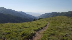
I feel like I should know this. Like maybe that's West Mountain and Utah Lake in the distance with Buckley Mountain on the right? Or perhaps further south somewhere like looking out of Hobble Creek Canyon. But I can't quite figure out where the picture was taken from. I must be way off! =)
- Joined
- May 31, 2015
- Messages
- 3,329
There is a large lake off in the distance, but it's not Utah Lake. And there's a town down at the bottom of the canyon. Like Hobble Creek Canyon, this is pretty close to a very urban area.I feel like I should know this. Like maybe that's West Mountain and Utah Lake in the distance with Buckley Mountain on the right? Or perhaps further south somewhere like looking out of Hobble Creek Canyon. But I can't quite figure out where the picture was taken from. I must be way off! =)
- Joined
- Jul 8, 2015
- Messages
- 251
Wow, not the Wasatch! Thought for sure it was up on Bountiful Peak looking towards Antelope Island. Oquirrh's then? Perhaps looking down from Nelson Peak?
- Joined
- May 31, 2015
- Messages
- 3,329
It's in the Oquirrhs! But you're too far north with that guess. Where I'm standing isn't a named peak, but if you can name the main canyon in the photo, or the general destination of the trail I'm on, it's yours.Wow, not the Wasatch! Thought for sure it was up on Bountiful Peak looking towards Antelope Island. Oquirrh's then? Perhaps looking down from Nelson Peak?
- Joined
- May 31, 2015
- Messages
- 3,329
That's quite close to where I was standing, and it's so close that any other hints would just be me saying where it is. Haha.Maybe the top of Butterfield Canyon?
This is looking down Middle Canyon, and you can see just a small bit of Tooele and out toward Grantsville. I was on my way up to Butterfield Peaks, having started at the pass that divides Butterfield Canyon from Middle Canyon.
Take it away, @Perry!
- Joined
- Aug 8, 2016
- Messages
- 2,078
Oh on the other sideThat's quite close to where I was standing, and it's so close that any other hints would just be me saying where it is. Haha.
This is looking down Middle Canyon, and you can see just a small bit of Tooele and out toward Grantsville. I was on my way up to Butterfield Peaks, having started at the pass that divides Butterfield Canyon from Middle Canyon.
Take it away, @Perry!
regehr
Member
- Joined
- Mar 28, 2012
- Messages
- 2,451
Will dig up a pic later today. Wish I'd known yours since I'd been there, but instead resorted to a bit of google earthingYessiree! You're up!
regehr
Member
- Joined
- Mar 28, 2012
- Messages
- 2,451
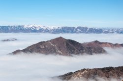
That rocky spine running down reminds me of Grandeur Peak, but I can't really square it up right in my mind because it would have to be an angle of it I've never seen.
you got it. this is from one of Mt Olympus's summits (I imagine south) during a nasty inversion. luckily the scrambly bit was not too icy, but the steep parts of the trail were horribly icy and I slipped and fell like a dozen times, it was actually pretty awful and I was bruised up for a week or so afterwards. I'll never climb Olympus in winter again w/o crampons.
- Joined
- Apr 20, 2013
- Messages
- 1,507
Don't like ads? Become a BCP Supporting Member and kiss them all goodbye. Click here for more info.

